
VL02316-02357-3x1v 9400x6100 pixels 3 frame 3 column 1 row 42 shot focus stack stitch blend a6700 17-40mm @19.2mm
enlarged vertical slice view image text section
NEXT: Page 5 San Antonio River basin
2026 Trip Chronicles: Contents
Antelope Valley 3/17
Antelope Valley 3/18
Carrizo Plain National Monument 3/19
After returning from Antelope Valley on Saturday March 14, I looked at weather information for the next period when Antelope Valley would have relatively low morning breezes and that was just 4 days later on Wednesday March 18. To be there, I would need to drive down the day before Tuesday 3/17. Thus spent time in the intervening days preparing gear, food supplies, and making field day plans. So mid morning Tuesday February 17, 2026, I waited until after peak morning commute traffic had ended, then drove south on US101 to SR152 to I5 all the way south across the Grapevine and into western Antelope Valley on SR138 by about 2pm. And note being still barely winter, these are Pacific Standard Times.
I made a quick tour of some dirt roads of interest near SR138 at West 120th Street, that still had plenty of nicely green dense poppies and other flowers while the drier appearing state park zone still did not. Great! It was still oo early to waste time working subjects in harsh sunlight. The temperature was warm, with the high officially 89F with a forecast of low 90Fs in following days. I drove east 20+ miles into Lancaster for gasoline, ice, and perishable food, that soon filled with ice, into my much cheaper Yeti knockoff, 26 quart cooler that is much better at keeping perishable food cooler for days versus any Styrofoam cooler designs. I also own two large mouth half gallon steel vacuum bottles and one quart sized, that keep drinks and or food cool for days during warm desert road trips.
Back out on SR138 to the West 120th Street zone about 4:30pm, I drove out south on the dirt road into blazing orange poppy fields. View the Copernicus3.jpg map on previous page 3. In one area, a dozen vehicles were involved in a commercial fashion photographer shoot with women models in fancy clothing, walking about in the poppies beside a range of photography studio gear and boxes piled up all about. And despite being midweek, there were numbers of other wildflower seekers driving those roads too. My first subject was a 3 column stitch blend that was unusable because the right column focus bracket process stopped to soon. Was able to process as a 2 column stitch but aesthetic is modest. My second subject also had focus issues that fortunately didn't repeat again through the road trip.

VL00995-01053-2x1v 6100x6100 pixels 2 frame 2 column 1 row 59 shot focus stack stick blend a6700 56mm
enlarged vertical slice view
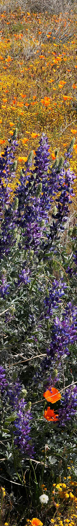
My third subject above worked at 4:53pm, a 2 column stitch blend, worked well and was much better aesthetically. There were enough high clouds to nicely evenly illuminate the curl closing California poppy, Eschscholzia californica. All the poppies and purple owl's clover, Castilleja exserta, were amazingly all about the same height showing they began their seed phases after the February storms at the same time. I do like having located a group of flowers without the hated cheat grass clumps. A few green patches of filaree plants plus a few bicolor lupine, break up the mixed orange/purple pattern.

VL01136-01222-3x1v 9100x6000 pixels 3 frame 3 column 1 row 88 shot focus stack stick blend a6700 a6700 17-40mm @40mm
enlarged vertical slice view
My sixth subject above at 5:04pm a 3 column stitch blend at 40mm, was similar with more poppies and a bit more lupine up front plus gone to seed filaree.

VL01224-01340-3x1vnbsp; 9100x6000 pixels 3 frame 3 column 1 row 117 shot focus stack stick blend a6700 a6700 17-40mm @40mm
enlarged vertical slice view
The above seventh subject, a 3 column stitch blend again at 40mm, focused on a large patch of dense owl's clover with clumps of California goldfields and ugly, gone to seed filaree. The sun at a low altitude near sunset, had moved below clouds creating less evenness in the flower color while low spots showed unaesthetic dark shadow zones. Poppies had become mostly curled up.
After that, worked another 2 subjects till 5:17pm with growing shadows between flowers becoming too unaesthetic. I drove around some, but the light was dimming in a way that also made the flowers duller than earlier. Although I've only posted 3 subjects from the 9 subjects worked in this day, the other images are reasonably strong, just not nearly so as the above 3, while being too similar to bother adding.
So instead, began driving around for a dirt road in the area to park and discretely sleep overnight. I ended up on the Antelope Buttes, atop a 2650 foot minor hill with wide views in all night directions. Fifteen aerial miles east, were the lights of Lancaster and Palmdale urban area with its 360,000 population (2020) while to the north, were lights of all the many solar farms and wind energy turbines with the latter running a red light blinking pattern covering many miles towards the Tehachipi Pass wind farms where in that distance, another similar blinking red light group ran. To the south, it was much darker with scattered ranch home lights.
Before getting into my back bed sleeping area, I enjoyed a clean refreshing bottle wash in the 75F degree evening. I brought along 2 each five gallon water containers, so had plenty of water. It never dropped below 65F atop my hill due to an inversion layer, while lower areas reached 60F.
By sunrise Wednesday March 18, 2026, that was about 6am, I was outside atop the hill moving gear around preparing for a day of field work, while in the distance was a constant rumble from SR138 semi-trucks and commuters. Thus, began driving about within the dirt road maze quite, looking for nicely green areas with a good flower mix, that the sun would light up early. Poppies and creamcups open slowly most mornings so I needed to wait at least an hour. I was surprised how much the zone I'd photographed the previous week had changed in just a few dry days.
I was also surprised to find a zone outside the fenced state park borders with new wire fencing with conservation organization signs, that protects against illegal dirt bikes riders that during non spring times of year have been increasingly damaging unprotected areas outside the park. Although I see nothing online, it is terrific that some land organizations are working to buy up and protect these valuable lands. Originally decades ago, the state park would have included the outstanding Fairmont Butte zone but there was trouble negotiating its sale. I finally parked, ducked under the conservation zone wire fence, where I clearly found the best zone for morning subjects.

VL01463-01530-3x1v 8100x6000 pixels 3 frame 3 column 1 row 68 shot focus stack stick blend a6700 a6700 17-40mm @22.6mm
enlarged vertical slice view
The above was worked at 7:53am with a typical lumpy pattern of flowers but with much cheat grass, serving purpose of showing how that alien grass along with its alien brother, filaree past its blooming period, significantly decreases aesthetics. Also note how many poppies were still closed.

VL01885-02046-4x1v 10400x6100 pixels 3 frame 3 column 1 row 162 shot focus stack stick blend a6700 a6700 17-40mm @37.5mm
enlarged vertical slice view
After 2 more similar subjects with too many cheat grass clumps, at 8:25am worked this 4 column stitch blend composition showing most of the poppies were now nicely opened to a vase shape. Note at frame lower center, the bicolor lupine seed pods. The strong fragrance of California goldfields indicated some had risen since my visit 5 days earlier.

VL02047-02114-3x1v 9000x6100 pixels 3 frame 3 column 1 row 78 shot focus stack stick blend a6700 a6700 17-40mm @37.8mm
enlarged vertical slice view
My final and best subject in these Antelope Buttes was at 8:56am, a 3 column stitch blend mix of shorter plants mixed within newly rising grass blades created a nice soft effect.
I drove out a long ways west on SR138 trying to find a way north on dirt roads to poppy landscapes I'd visited in the past, however most of those roads are now gated or posted with NO TRESPASSING signs. A result of many more homeless people squatting onto these areas, including dragging considerable junk therein, especially rusting abandoned vehicles. So, the rest of us are now locked out too. One zone I wanted to explore possibly reaching, were the hills on the south side of Antelope Valley, south of the blocking California Aqueduct. To the east, those areas are blocked by gates or signed private roads.

VL02115-02152-3x1v 8200x5900 pixels 3 frame 3 column 1 row 38 shot focus stack stick blend a6700 a6700 17-40mm @36.9mm
enlarged vertical slice view
An hour later at 9:50am with a growing breeze making work difficult, I was about the east end junction of Lancaster Road at SR138, where I stopped to work the above area of flats with just risen dense bright, fragrant, California goldfields, mixed with California poppy and cyan-gray hued rubber rabbitbrush, Ericameria nauseosa. Filaree in the zone had apparently bloomed in January and since gone to seed looking quite unaesthetically dry within clumps mixed with cheat grass.

VL02181-02v 6150x4100 pixels 1 frame 7 shot focus stack blend a6700 a6700 17-40mm @21.6mm
enlarged vertical slice view
At 10:14am further east along paved Lancaster Road, parked and followed up a wash into what was likely unfenced private lands towards colorful nearby hills. I was glad to find numbers of species not found near the state park, though much had a dry look indicating I was about a week late from better conditions. I worked the above single frame landscape, that has an excellent seed bed worth returning to during a future spring. In the background, the yellow hues are California goldfields, and dark trees, California juniper.

VL02194-02h 5400x4100 pixels 1 frame 9 shot focus stack blend a6700 a6700 17-40mm @21.6mm
enlarged vertical slice view
One prominent species in the area were big silver bush lupine, Lupinus albifrons. The above unaesthetic image worked at 10:30am, shows how dry the landscape had become. Also includes desert pincushion, Chaenactis fremontii, drying California goldfields, California poppy, bicolor lupine, drying filaree, fiddleneck, and much cheat grass.

VL02245-59h 6150x4100 pixels 1 frame 7 shot focus stack blend a6700 a6700 17-40mm @21.6mm
enlarged vertical slice view
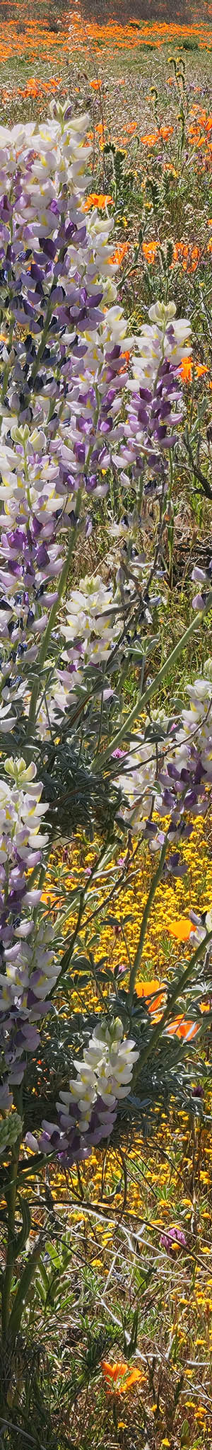
At 10:42am, came upon the above rare plant with a mix of albino DNA. Many wildflower species have occasional white colorless versions while the above had petals of purple-blue color and white. Was tedious to process in Zerene Stacker because the tall, erect spikes, termed racemes had slightly moved about out of registration, but worth the effort. Also in the mix, California goldfields, California poppy, purple owl's clover, rubber rabbitbush, bicolor lupine, filaree, fiddleneck, and much cheat grass. That zone also had much chia.
Back east along the paved road, I explored out on various dirt roads and found one rather ugly road with deep dust that eventually brought me exactly to what I was looking for, an entrance to the road, ranch owners use south of the aqueduct against the hills. Much of the road was part of the California Aqueduct system with areas of cement, water was in a pipeline beneath. I stopped at a steep slope with a wide range of flowers, climbed up, and tried to work an image. However, the breeze was too strong and in any case it was like the rest of this zone at least a week too late, looking dry.
A bit before noon, came upon two fabulous small canyons with much bigelow coreopsis, Coreopsis bigelovii , California poppy, tansy phacelia, Phacelia tanacetifolia, and desert pincushion. At midday this created a striking image against a deep blue sky. Fortunately, the breeze had also subsided to a workable level. At page top, was my second composition. The coreopsis at the top of the hill had already lost petals, browning, going to seed. A location, I expect to return to in the future as Google Earth satellite images from earlier springs show plenty of colorful flowers.

VL02358-02408-3x1v 9300x6100 pixels 3 frame 3 column 1 row 48 shot focus stack stick blend a6700 a6700 17-40mm @20.6mm
enlarged vertical slice view
And a third similar strong image above at 11:56am, with tansy phacelia, Phacelia tanacetifolia, in the foreground. With harsh midday sun plus a breeze, it was time to end my Antelope Valley work. I drove west on SR138 to Quail Lake, an aqueduct system reservoir to a fishing access parking lot, with much greenish algae in its waters. Despite legal warnings of possible drowning, I enjoyed a quick refreshing submersion in what was 94F degree heat.
I continued north on I5 over Tejon Pass to Frazier Park where I stopped for a strawberry milkshake. Then instead of continuing down the Grapevine, took a more scenic route to Carrizo Plain via Frazier Park Road to Cuddy Mountain Road, to Mil Potrero Highway to Hudson Canyon Road Forest Highway 95 to Cerro Noroeste Road. That route with very few wildflowers and dry chaparral woodland, was shorter, but no faster due to windy mountain curves. Along that route that receives snow during winter, were areas of expensive homes among what appears to be a very dangerous looking dense fire prone arid chaparral mix forest.
By mid afternoon, reached the southern SR166 at Soda Lake Road junction, then continued north into the national monument. I returned to my familiar favorite dirt road, dispersed camping spot that I had used the week before. After setting up camp and my car for the evening, cooked some dinner on my MSR Whisperlite.

By mid afternoon reached the SR166 Soda Lake Road junction, then continued north into the national monument. And returned to my favorite dirt road, dispersed camping spot that I had used the week before. After setting up camp and my car for the evening, cooked some dinner on my MSR Whisperlite. At the top of my camp zone hill at 5:37pm, worked the above mediocre, 4 column stitch blend panorama using single frame shots at infinity focus. With the breeze too strong, did not bother with any further photography this day, so retired into my vehicle a bit before sunset.

VL02700-02735-3x1v 9100x6100 pixels 3 frame 3 column 1 row 36 shot focus stack stick blend a6700 a6700 17-40mm @35mm
enlarged vertical slice view
Sunrise Thursday March 19, 2026, planned spending early morning near the camp zone then would depart for home. This above 3 column stitch blend image with my zoom at 35mm at an early 7:19am, shows a view east northeastward with the Temblor Range in the heavy water vapor distance. Wildflowers looked much drier, and less saturated with color than 6 days earlier, an example of how critical it is for a photographer to visit these areas near peak.

VL02736-02762-3x1v 6500x6100 pixels 3 frame 3 column 1 row 27 shot focus stack stick blend a6700 a6700 17-40mm @29.7mm
enlarged vertical slice view
Then at 7:21am, despite the sun exposure, some of the California goldfields were still freshly risen with fragrance. Also, purple owl's clover, hillside daisies, chick lupine, filaree, fiddleneck, white fiesta flower, ephedra, and 5106 foot Caliente Mtn. Note the white vehicle disperse camping atop a hill in the distance.

VL02773-02809-3x1v 8800x6000 pixels 3 frame 3 column 1 row 27 shot focus stack stick blend a6700 a6700 17-40mm @29.7mm
enlarged vertical slice view
Then at 7:36am, worked a similar landscape with a purple owl's clover foreground plus hillside daisies, chick lupine, filaree, fiddleneck, white fiesta flower, green ephedra, and 5106 foot Caliente Mtn. Note upper frame left, my white vehicle that was parked on a dirt road.

I was soon on Soda Lake Road driving north. I stopped, then walked out to Soda Lake to work a reflection image, but deleted the mediocre result. Continuing north and out of the monument, along SR58 across from the local school, I drove a dirt road east through 2 closed cattle gates that I got out each time to open and close, and near the road end, walked out a half mile, where at 9:36am worked this above modest landscape of an expanse of purple owl's clover.
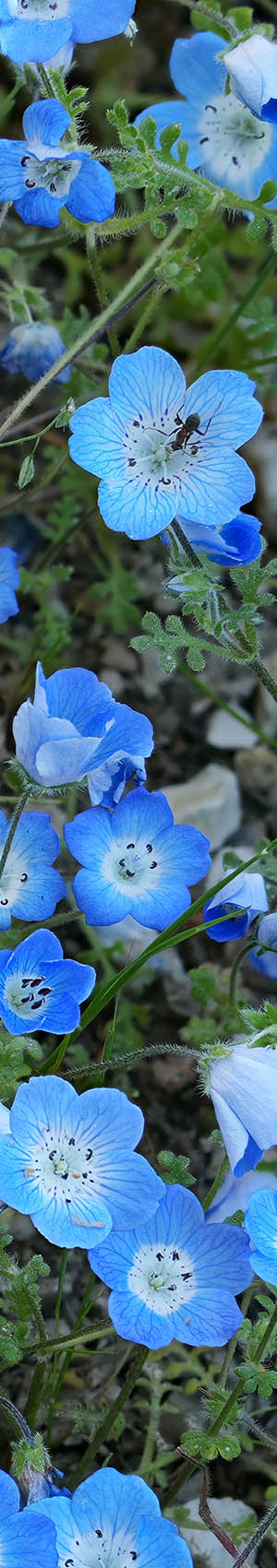
Back on SR58, a short ways further, stopped to try and capture across a fence some rather nice mixed areas of flowers, however that too was deleted due to too much breeze moving elements. So by 10:15am was on my way west on SR58, then through Paso Robles to US101 where I continued north to Bradley. There, I vectored off on Jolon Road where I began stopping for roadside work of baby blues eyes patches.

VL03053-72v 5400x4100 pixels 1 frame 9 shot focus stack blend a6700 a6700 17-40mm @21.6mm
enlarged vertical slice view
The roadside areas were steep, with poison oak about. A breeze made the effort difficult. The above close-up at 12:24pm with my 56mm lens was the only subject of baby blue eyes, Nemophila menziesii, that I managed to capture. Midway into the focus bracket sequence, the breeze began so I pressed the remote shutter release again that stops a sequence. So the more distant flowers are not in focus. I kept trying for most of another hour before continuing north, then back onto US101, the rest of the way to San Jose.
NEXT: Page 5 San Antonio River basin
2026 Trip Chronicles: Contents