
VK08552-08578-3x1v 8900x5900 pixels 3 frame 3 column 1 row 27 shot focus stack stitch blend a6700 17-40mm @33.4mm
enlarged vertical slice view image text section
NEXT: Page 3 Carrizo Plain National Monument 3/13 2of2
2026 Trip Chronicles: Contents
Carrizo Plain National Monument 3/10
Carrizo Plain National Monument 3/11
Carrizo Plain National Monument 3/12

By the end of February 2026 given weather data and web reports, I was expecting to visit Carrizo Plain and Antelope Valley. Anza Borrego and Death Valley were also having wildflower blooms, however they weren't nearly as strong as during my past visits and would require much longer drives to reach at a time when gasoline prices were surging. For a savvy Internet user, there is much more information available on California wildflower bloom areas than even a decade ago. Note, I don't have any post smartphone social media accounts, that also have reports. The below shows the 2025/2026 water year graph for CAZC1, the only precipitation station within Carrizo Plain that is 195% of normal. Areas to the west like Shell Creek didn't receive any rain from the February storm.

The below, are links to previous Carrizo Plain photography road trips during last dozen years. Before I began digital camera work in 2014 with the Sony a6000, I also visited these areas with my Wisner view camera. However, few of those Provia 100F transparencies have yet been drum scanned, that is an $80 process, I'll defer till the future:
2015 Carizzo Plain 3/10
2017 Carrizo Plain National Monument 3/31 1of2
2017 Carrizo Plain National Monument 4/6
2017 Carrizo Plain National Monument 4/10
2017 Carrizo Plain National Monument 4/11
2019 Carrizo Plain National Monument 4/10
2023 Carrizo Plain 4/20
2024 Carrizo Plain 4/1
2024 Carrizo Plain National Monument 4/9
The below is a Copernicus.eu satellite image from March 11, 2026 that along with a March 1 image, I made great use for evaluating where within the vast Carrizo area I would work. The magenta and orange dots correspond to points on inset images showing as lines where I hiked. The blue dot at 3900 feet is where I drove up into the Caliente Range for below Pixel 10 Pro photos and the green dot is where I disperse camped 2 nights. Note above that green dot, purple areas showing valley phacelia. For scale, Old Potato Lake is a mile long to its island. The yellow hued areas northeast of Soda Lake are goldfields that began blooming about a week after the last late February storms.
The image above right compares this year's only yellow bloom in the Temblor Range against the 2019 bloom that shows vastly more color. By April this year, even the yellow areas had gone to seed, browning.

Despite the considerably more information available in this Internet era, most of these remote areas are vast with limited weather sites, and given the variable nature of storms, especially in mountainous zones, the amount of rain may be very uneven that was apparently the case in both regions I visited. Another key factor in how strong blooms may become, even given heavy rains, is what current seed beds contain. Some winters, annual seeds germinate after good early storms but then wither if early spring is warm and droughty. Thus in following years, areas that had previously bloomed strongly may be weak due to diminished seed beds. I do suspect that is a reason the Temblor Range and Antelope Valley California Poppy Reserve State Natural Reserve were both mediocre this 2026 spring, while adjacent landscapes were far better as a sign of that pattern is repeated poor blooms despite strong rains. It then takes a few years to build seed beds back up. Also, another factor this spring were the two long exceptionally warm dry spells that caused blooms to occur 2 to 3 weeks earlier than normal.
As a side note, the California state park system has an annoying habit of regularly changing the official name of the poppy reserve.
Another factor in when I time my trips is for weather wind websites showing low breeze conditions since I focus stack blend that requires relatively still subjects, especially anything close in foregrounds. Given the increasing gasoline costs, I locally filled my 2023 Trailblazer LS tank at $4.49/gallon. Thus, left mid morning on Tuesday March 10, 2026, driving south 160 miles in light traffic down US101 to Paso Robles where I topped off gas for $5.19/gallon plus added ice for my ice chest. There are no gas stations or food markets to the east along SR58, so at its Albertsons supermarket, bought perishables including a gallon of milk, yogurt, and a tuna fish sandwich.

At 1pm, I reached Shell Creek, where it appeared most flowers bloomed in February after the long dry spell following the New Years holiday storms. The February storms missed this area, that is why by my visit, landscapes were rather dry with a limited bloom. I did get out, then explored awhile taking a few Pixel photos. By mid afternoon, had reached 50 mile long and up to 15 miles wide, Carrizo Plain where I first stopped along Seven Mile Road, hiked out some, and found familiar areas unremarkable. In any case, there was enough of an afternoon breeze that I would not have taken my Sony a6700 out of my daypack. Then drove south into the National Monument and northeast on Simmler Road where I parked in order to explore the large expanse of yellow on the noted above satellite images.
All the Pixel 10 Pro images herein, are downsized images to fit window page sizes. The native output given my settings is 4080 by 3072 pixels or just enough to fill a 4k screen. However such outputs at full size, do not look as sharp as a my a6700 processed images. So in post processing, I downsize at least about 20%. I will now be carrying the Pixel versus my Canon ELPH190 compact digital camera to work less serious subjects handheld. Using (now free) Kolor Autopano Giga, it also makes surprisingly good hand held panoramic images. A key reason I finally purchased this high end smartphone camera was its high quality 5X zoom lens that uses a separate 48 megapixel sensor. I also installed the Open Camera app that could allow focus bracketing when the smartphone is tripod mounted. So will report on that, in the future.
I began more serious photography in 1980 with the rise of 35mm SLRs, specifically the Olympus OM-1. Since that time have never bought or used the specialized photography backpacks the vast majority of landscape photographers use. Instead have used daypacks with lenses in ordinary soft lens cases, just placed in main compartments wherever. My Osprey Scarab 32 daypack has 3 smaller at top zippered compartments I make much use of with many small items plus a mid-sized back compartment and 2 small waist belt compartments. Despite all the treacherous locations I visit, especially off trails in the Sierra Nevada, have never damaged any gear due to my daypack gear carrying method. During years I carried the Wisner Expedition 4x5 view camera, all that in its folded up state were in special cardboard boxes I custom built that then also went into daypacks.

My 3 mile hike took me, per the above Copernicus1 image, along the magenta line path. Although I had all my camera gear, there was enough of a breeze, that I just snapped a few hand held Pixel 10 Pro photos. My above eastward Pixel image, shows a shallow alkali pond along my route with the expanse of two species of goldfields. In the background, is the Temblor Range. The sparse taller plants with light green stems are the alkali goldfields while the more abundant shorter shin high species are California goldfields. The image is strong enough with interesting water reflecting pools, that in the future, I may more seriously work these flats during morning calm periods on clear air days. Upper mid frame shows the old bulldozed levee I walked out on before dropping into this area at frame right. Levees were built during the early 20th century by real estate interests and then abandoned due to drought. There is still much cheap undeveloped, marshy, land for sale north of the national monument. Hillside daisies dominate among mixed species in areas from the levee eastward.
Walking about in these level bottomland areas is rather tricky as the deep white alkali soil is quite soft with boots readily sinking in to depths I was keen to avoid finding out about how much. But then at 5'6" 135 pounds, I'm a small person. Gear/clothes/boots adds another 20+ pounds. Not a place for a heavy person to be. One cannot approach water in any of the alkali ponds as one would sink in deeply and animals are quite aware of that, as one will only see bird tracks along its bleached white shores. And that mud is horribly sticky, requiring much boot sole cleaning to remove, haha. I love the experience of exploring such amazing places that is as important as photography goals.
Late afternoon, I drove the dirt Selby Road to the Selby Campground with restrooms and potable water, where besides the already taken regular sites, one can just park anywhere to overnight. The campground standard sites with tables were full. It was nicely quiet during the night, reflecting the type of considerate folks that seek out our more remote natural areas.

VK07939-07999-3x1v 4100x6150 pixels 1 frame 61 shot focus stack stitch blend a6700 56mm
enlarged vertical slice view
Awake at dawn on Wednesday March 11, 2026, I packed up, then drove back out on Selby Road to a landscape where I parked then hiked out for about a half hour in dim morning light about dense patches of purple owl's clover. Then drove back to Simmler Road where I stopped within a quarter mile to at 7:26am work the above showing the northeast bay of shallow, not close to full, alkaline, Soda Lake with lower northern hills of the Caliente Range in the background. A minor night breeze was still active that to reduce mis-registration effects, had me put the foreground with tidy tips, Layia platyglossa, great valley phacelia, Phacelia ciliata, and fiddleneck, Amsinckia spp, well back, about 15 feet away.
Dirt Simmler Road is atop one of the higher, old, bulldozed levees. There was one ugly mud pit near the west end to discourage 2 wheel drive drivers, while most of the road as well as Soda Lake Road and Caliente Mountain Road, had recently been nicely flattened out by road graders that also eliminated the horrible dustiness they become during dry periods. Considerate visitors on Carrizo's dusty dirt roads, should slow down as they pass vehicles in opposite directions, much less people roadside.The above was my first APS-C Sony a6700 landscape of the trip, a 3 frame 3 column 61 shot focus stack and stitch blend with my Sigma 56mm very sharp prime medium telephoto lens that is also my primary lens for any close-up work. All the a6700 images on my Chronicle pages are downsized for the web to sub 952 pixel width sizes that lose much detail. Viewing the enlarged vertical slice view links below each image that is at 50% pixels, provides an indication of true detail.

VK08230-08262-3x1v 9000x5900 pixels 3 frame 3 column 2 row 33 shot focus stack blend a6700 17-40mm @42.7mm
enlarged vertical slice view
I drove a minor distance northeast on Simmler Road, parked, and then set out due east per the orange line on the above copernicus.eu image on what would be my primary work this day. On Tuesday had carefully noted this zone had more robust blooms while areas further east appeared drier without the usual large expanse of Bigelow coreopsis. I've explored these areas in the past while 98% of visitors, even those with serious camera gear, rarely walk more than 100 feet from their vehicles. After working a landscape at the first pond along my orange line route, I stopped at the second pond to work the above 3 frame stitch blend, showing the circular edge of the pond. Note the lack of pond water clarity due to suspended fine alkaline particulates and algae. As noted, animals don't walk on these soft alkali pond shores where one will only see bird footprints. Almost all images worked this morning were with my recently expensively bought Sigma 17-40mm F1.8 DC Art zoom lens.

VK08263-08308-3x1v 8900x6000 pixels 3 frame 3 column 1 row 46 shot focus stack stitch blend a6700 17-40mm @30.9mm
enlarged vertical slice view
I then continued until reaching the south end of large, shallow, Old Potato Lake at the 1910 foot elevation where I looked for foregrounds. By later summer, all these alkali waters may have dried up. As the morning progressed, sunlight warmed dewy vegetation and grounds, disconnecting the night flow sumping breezes originating in valley surrounding canyons. This spot had a large flat of California goldfields, Lasthenia californica. In the above 3 frame stitch blend at frame right, is the west end of its large island with the rest of the far shore as much as 1.2 miles distant. At frame left is a perennial saltbush, Atriplex lentiformis, that are also most of the dark spots in the distance. Other than brief spring bloom periods, they along with iodinebush, are the only living plants in these hot alkali valley areas.

VK08399-08440-3x1v 9100x6000 pixels 3 frame 3 column 1 row 42 shot focus stack stitch blend a6700 17-40mm @40mm
enlarged vertical slice view
I wandered back towards pond 2 for the above image westward with freshly risen Bigelow's coreopsis, Leptosyne bigelovii, filaree, Erodium spp, fiddleneck, Amsinckia spp, alkali goldfields, Lasthenia ferrisiae, California goldfields, and saltbush. In the distance are hilly areas of the northern Caliente Range. One can always tell where goldfields have recently bloomed out of buds as they have a nicely sweet fragrance that evaporates within a few days. By this point of the morning at 9:12am PST, the breezes finally nulled, so I needed to work as quickly as I could before that changed with stronger breezes above the ground surface mixing downward. And yes, everywhere were sounds of zillions of happy buzzing bees.

VK08441-08505-4x1v 12200x5900 pixels 3 frame 3 column 1 row 65 shot focus stack stitch blend a6700 17-40mm @40mm
enlarged vertical slice view
This next image above northward at 9:19am, is a 4 frame stitch blend of 65 shots, a 12,200 by 5900 pixel image, showing what most of these areas look like with perennial saltbush interspersed with flats of purple owl's clover, Castilleja exserta, and California goldfields, plus scattered tidy tips, valley phacelia, recurved larkspur, Delphinium recurvatum, and clumps of cheat grass. The less high north end of the Caliente Range is in the distance.

VK08506-08543-3x1v 9000x6000 pixels 3 frame 3 column 1 row 38 shot focus stack stitch blend a6700 17-40mm @29.5mm
enlarged vertical slice view
Then at 9:28am, worked the above image, the last during this morning's session, as indeed a stronger breeze quickly developed. So, the near calm period just lasted about 15 minutes and occurred in the valley bottom zones mid morning after the sun had balanced light night down canyon flows from surrounding mountains. At foreground right are Bigelow's coreopsis, filaree, California goldfields, tidy tips, saltbush, and the Temblor Range. Some of the coreopsis are brown gone to seed, that shows they probably first bloomed by late January during the warm dry spell and then after the mid February storms, surged upward with new stems and buds. Note the haze at frame left, that is mostly the evaporated dew that coats vegetation early morning. A reason I wore gaiters. I felt like I had located the best zone of mixed flower species but then a continuous breeze arrived too soon, as is often the case. Thus, was intent to return either the next morning or Friday?

After the 1.5 mile hike, I drove to the visitor center to see what is new since it has been nicely upgraded with well-designed exhibits. I'd like to personally thank William Jefferson Clinton for creating the 246,812 acre, Carrizo Plain National Monument, during his presidency. Though under-appreciated for generations, due to its most common droughty, wasteland appearance, and lack of all year water sources, the monument is arguably after wet years, the greatest wildflower expanse on our continent. During this Internet social media era, the public is finally becoming aware of that reality.
I then drove up on the dirt Caliente Mountain Road that rises to about 4000 feet or 2000 feet above the valley. The road is often narrow and treacherous, especially when another oncoming vehicle passes within narrow or steep sections. And after even minor rain storms, the gate is wisely closed. The above Pixel 10 Pro image from a 3900 foot viewpoint at 12:09pm, is west northwestward showing areas of yellow hued hillside daisies. The burnt California cedar at frame left is the result of the July 2025 Madre Fire. Fire crews used backfires down in the Caliente Range foothills to prevent an advance across the plain. Just west of the monument proper, the fire burned across most of the 38,900-acre Carrizo Plains Ecological Reserve that consists of oak and juniper woodland, chapparal, grassland and desert and coastal scrub, most of which is expected to recover from fire impacts and benefit from the elimination of invasive alien Eurasian grasses.

The above Pixel 10 Pro image at 5x, looks down at Selby Campground where I parked Tuesday night. Its local zone had plenty of nice wildflowers to explore. I had wanted to hike down into the ravine at frame right that will need to wait till the future. The dirt road junction at frame left is the start of the gated Caliente Mountain Road. The narrow pathway from the campground loop turnaround, is the Caliente Mountain Ridge Trail that routes all the way up to the road atop the crest of the range where one can continue to walk for miles that ends at 5106 foot Caliente Mountain. Wildflowers were only modest along that road, much less impressive than the Temblor Range areas in better years.

Another Pixel 10 Pro image east northeastward, showing nicely green landscapes south of Old Potato Lake at frame left, with a maze of alkali channels and goldfield flats almost I'd expect no one ever ventures into. Much of the CM dirt road is visible. Just left of frame center per magenta dot, is the square shape of a huge Winnebago RV that had unwisely started up the road and then stopped at the last point it might be able to turn around. Carrizo Plain is a dangerous place for vehicles, especially after rains turn the alkali soils into horrible mud that sticks to one's tires and much worse on hiking boot soles, haha.

I drove south on Soda Lake Road that soon changes from paved to graded dirt and after several miles out on an obscure a 4wd spur dirt road to a familiar hilly location at 2245 feet amid vast expanses of colorful wildflowers. Two of us camped there in 2019, where I found the same wonderful spot unoccupied. The monument map shows areas where dispersed overnight parking is allowed and there are also numerous private inholding lands, those unfenced, a gray area. For anyone disperse camping, one won't find any natural shade like trees.

Significantly, it was a zone I knew had a large seed bed, and a mix of more species unlike in the valley or Temblor Range, where storms apparently dropped plenty or rain with more flowers in peak bloom than we'd seen in 2019. I immediately decided to spend the next morning, Thursday, in this area. Storm rainfall was obviously uneven across the 50 mile long valley, so while some areas had lots of flowers others were mediocre as spotty February storms left little, just as I had seen at Shell Creek. During these harsh sun midday hours, I set up my 2-night base camp, reorganized gear, cooked a Progresso Tortellino Pasta soup lunch on my MSR Whisperlite backpacking stove, then napped in the shade of my sun blocking positioned vehicle. Although I could have set up my tent, I prefer sleeping in my comfortable vehicle back bed as I otherwise get plenty of tent camping each year.
The image at right shows my 2023 Trailblazer LS back bed sleeping setup. The rear passenger seat is folded down. The red layer is a high end, closed foam aerobic mat I bought cheap used while the yellow layer a foldable foam Therma-A-Rest Z-Rest pad I use when backpacking. Atop that are 2 older synthetic sleeping bags I tend to use blanket style. Beneath are 2 wood boards that help flatten out the bed and can be used under tires if becoming stuck in mud, sand, or snow. Because I snow ski, I also carry tire chains and a heavy-duty nylon towing rope. The red pad is tilted up at my head end during the day as I place my 26 quart cooler there against the passenger seat. At night I place anything like food etc atop the rear driver's side seat while my daytime photography gear is moved to the front passenger side seat and floor. That floor is also where I place two each five gallon plastic water containers. At night, the rear seat windows are lowered slightly for fresh air flow.
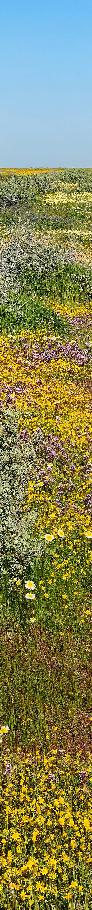
About 1:45pm, I headed out with gear after the breeze began showing signs of slackening. I went right to a blazing patch of purple owl's clover about a quarter mile away from my camp spot. Although I would be able to work it the next morning, by shooting northeastward, was able to include the 6.5 mile distant Temblor Range while a morning photo would be dull, back lit. Thus captured the image at page top that required considerable manual Zerene Stacker work due to moving plant elements. As it turned out, the next day was breezier than I hoped, so I didn't work that area again. Back near my camp, worked a few hopeless shots in an impossible minor breeze that I immediately deleted back home. For such image sets, I'll keep the first shot in a set as a place holder that helps mentally recall events later. After 5:30pm near sunset, at the top of the small hill behind my camp, also worked some distant 56mm and 85mm telephoto shots eastward towards the Temblor Range, none of which were interesting, as dirty San Joaquin Valley air from Kern County had flowed west across the Temblor Range.

VK09062-11v 4100x6150 pixels 1 frame 50 shot focus stack stitch blend a6700 56mm
enlarged vertical slice view
After the sun went down, and the breeze quickly calmed, in diffuse skylight, worked three thistle sage, Salvia carduacea, subjects in the dry wash next to my camp, probably the best location I've encountered in the monument for these sparse, beautiful flowers. This third subject above includes yellow chaenactis, Chaenactis glabriuscula, purple owl's clover, fiddleneck, and filaree. The single frame image required 50 focus bracket shots and includes a great amount of exquisite fine detail. There are a few fiddleneck species only a botanist is likely to be able to specifically identify.
The other two subjects included cheat grass, a Eurasian widespread alien species brought by settlers for cattle feed, that has totally replaced many native species destroying original California landscapes. It is also an unwanted element in many of my close-up subjects statewide and the most likely plant to be moving in even slight breezes. The filaree, aka storkbill, Erodium genus species, is also a widespread Eurasian cattle feed alien though has pretty small pink flowers and being low to the ground doesn't move around easily in breezes.

The above upper 4 viewfinder images are my a6700 Menu... Shooting... Focus Bracket settings that for my uses have never changed. I set the a6700 with a 50 focus bracket limit and that is sometimes reached with close-ups. Despite less sharpness, I prefer F8.0 for flowers instead of F5.0, that I prefer with landscapes, as it reduces parallax halo issues, that close-ups at low apertures often have. Setting up the a6700 is quite confusing, especially its custom button settings. Almost all my work is in Aperture Priority mode at ISO 200 or 100 if dead still, and most often use -0.3 exposure levels. My C2 button on top has been Custom set for toggle switching between Auto Focus and Manual Focus. The C3 button is set for Auto Exposure Lock, AEL, Hold. The bottom 2 images are settings for my Bluetooth remote shutter release that also must go through an initial one-time pairing process. For vibration free a6700 shutter activation, I use a 1.8 ounce, 3 inch long inch wide, $30 PHOLSY RMT-P1BT Bluetooth Camera Remote Wireless Release Shutter Commander.
Quiet spring mornings in these hills are magical at dawn with several species of birds singing. I love opening my car windows in cool early dawn. On Thursday morning March 12, 2026, was up, secured vehicle, then a bit after sunrise, walked out to the same zone with a large patch of purple owl's clover I worked Wednesday. By 7:15am PST, I worked one vertical column that I later deleted due to a camera malfunction.
While taking the first set of focus bracket shots of what was to be a 3 column stitch blend, the camera's 64gb memory card became filled mid way during the bracket sequence. With power off, I replaced the media with a second 64gb card, but somehow the subsequent focus bracket shot sequence assignments to actual shots became incorrect while also mixing set shots into the adjacent subject sets. Takeaway is, never allow the a6700 SDcard memory to become close to filled when working Focus Bracket mode subjects before replacing a card with a new card.
I wasn't aware it was happening until much later at home looking at the Excel listing using Adobe Bridge. Somehow, it fortunately self corrected over the following long night power off period, so was only incorrect on all focus bracket subjects for that one day. This has caused considerable difficulty processing all focus bracket shots for that date. The first 100 focus bracket shots within at least 10 vertical column sets had to be deleted. So, I lost some work. Several subjects between March 11 and March 12 also now use the same auto assigned filename number range that is further confusing.
On the web, read some warnings of the same thing happening to other a6700 users after a media change. Thus, need to be careful as the card nears capacity. In the field, I normally don't later review individual shots within focus bracket work except sometimes final infinity shots because the depth of field is so limited per shot say at f5. Fortunately, I was able to process with much difficulty, the image for the same subject that I took the previous afternoon at page top.

VK08284-08305-2x1v 6500x6000 pixels 2 frame 2 column 1 row 22 shot focus stack stitch blend a6700 56mm
enlarged vertical slice view
The first subject I was later able to post process was maybe the third focus bracket subject per above, 45 minutes after arriving as a breeze began at 8:03am. This above 2 frame stitch blend with my 56mm, was near the top of the ridge into the next ravine drainage. The dominate species in this zone as well as in the Temblor and Caliente Ranges are yellow hued hillside daisies, aka common monolopia, Monolopia lanceolata. Also in this image with a fine mix of colors, are phacelia, purple owl's clover, green ephedra, white fiesta flower, California goldfields, and a sliver of the Caliente Range. I walked up into that slope but then gave up due to the increasing breeze.
There were several more of these ravines further north I didn't have time to explore that possibly had just as strong material. I'm convinced due to its exceptional seed bed, that this hilly zone contains some of the strongest wildflower landscape aesthetics in the monument but to this point the public is not aware of such primarily because most is not visible from Soda Lake Road while the unmaintained, irregular dirt roads will deter most people with 2WD. Eventually, well into the future to eliminate plant trampling, the park may need to create at least a few more formal trails. The many sandy storm washes are natural routes to explore without negative impacts. For now, given relatively low numbers of visitors within a vast region, rambling about by foot anywhere off trails is not an issue.

VK08445-93h 5400x4100 pixels 1 frame 50 shot focus stack blend a6700 56mm
enlarged vertical slice view
There were plenty of intimate close-up subjects to capture while the breeze was intermittent at local ground levels, especially down within more out of the main wind pattern ravines. One subject I was intent to capture were the above image, low to the ground, beautiful chick lupines, Lupinus microcarpus, that are abundant on flats in these hills, mixing with California goldfields, filaree, and often purple owl's clover.

VK08544-93h 5000x3400 pixels 1 frame 38 shot focus stack blend a6700 56mm
enlarged vertical slice view
Due to breezes, the above up against blue sky back lit image at 9:58am of phacelia, Phacelia spp, flowers took quite some effort to capture waiting for a null in the breeze. At the same time, was holding up above left out of the frame, my 32 inch diameter collapsible silver reflector to help illuminate this shaded side of the flower cyme. There are several phacelia species in the monument that are difficult to specifically ID.

VK08594-08631-4x1v 13000x6100 pixels 4 frame 4 column 1 row 38 shot focus stack stitch blend a6700 a6700 17-40mm @40mm
enlarged vertical slice view
At 10:29am breezes slackened probably due to a wind direction change at higher elevations above the ground that provided enough time to work the above 4 frame stitch blend landscape composed of 38 shots, showing what many of the flats in these hills look like. Purple owl's clover, chick lupine, California goldfields, green ephedra, aka Mormon tea, Ephedra viridis, white fiesta flower, Pholistoma membranaceum, fiddleneck, hillside daisies, phacelia, cryptantha, Cryptantha spp, and 5106 foot Caliente Mountain in the distance.
The perennial green ephedra bushes are one of the few live plants one will see in these hills outside of spring when moisture is still available. The odd drought tolerant ephedra is a 100 million plus year old ancient plant genus common world-wide in arid climates. Here in Carrizo Plain, they grow in well separated spots as dark spots dotting landscapes. Above ground are woody trunks. During spring, they are often densely adorned with white fiesta flower, and less often blue fiesta flowers. Other species like fiddleneck, cheat grass, kern mallow, and phacelia, also use their cooling shade
And importantly rodents and reptiles tend to colonize every clump that are apparent as round entrance pathways at ground level. Their animal scat concentrating the spring harvest, also help fertilize such clumps. Although the rodents like kangaroo rats only come out quietly at night, while walking about during daytime, I often saw lizards scampering back towards their protection and also a few desert cottontail rabbits. And the whole monument is alive with many bird species during spring that greatly prefer traveling from ephedra clump to clump.

My morning photo session ended about 10:40am, after which, I spent the following 4.5 hours at my camp, usually using the car as shade per the above by orienting the vehicle to block midday sun. Expecting there might be lengthy midday inactive periods, I always have plenty of food, water, drinks, and reading materials to keep occupied. And note, one is unlikely to have smartphone coverage except atop the ranges or at the visitor center.
About 3:15pm on this moderately breezy afternoon, I grabbed my gear and worked several subjects, that I've deleted almost all of, due to element movements I've declined to waste effort fixing. That was about 250 shots for 18 focus bracket sets, at an average of 25mb per shot or 6.3 gigabytes of valuable desktop disk storage space I don't need to keep. From each set I'll keep one shot as a placement record that helps me recall events of those times. In the future at my leisure, from a Command Prompt window, I'll run a large batch file moving these ~25mb placement files as full paths, into a single folder, then in Photoshop run Automate...Batch greatly reducing their sizes to less than 1mb, saving, and then with a second Command Prompt batch file, send them back to wherever they came, thus freeing up much space.

VK09043-09070-2x1h 8400x4000 pixels 2 frame 2 column 1 row 34 shot focus stack stitch blend a6700 a6700 17-40mm @35.0mm
enlarged vertical slice view
Near sunset in noticeably warmer light at 5:21pm, the breeze was finally low enough that I began to more seriously work a few shots. The above 2 column stitch blend includes purple owl's clover, fiddleneck, green ephedra, white fiesta flower, Parry's mallow, Eremalche parryi, California goldfields, hillside daisies, chick lupine, and the distant Temblor Range. Most of the flowers on this exposed to sun and wind all day site were already drying, near the end of their blooming phase

VK09079-09106-2x1v 6700x6100 pixels 2 frame 2 column 1 row 28 shot focus stack stitch blend a6700 a6700 17-40mm @40mm
enlarged vertical slice view
And a final subject for this Thursday, a similar ephedra image with green ephedra, white fiesta flower, Parry's mallow, California goldfields, purple owl's clover, dense flower owl's clover, yellow chaenactis, fiddleneck, Temblor Range, dense flower owl's clover, Castilleja densiflora. Parry's mallow at frame lower right, often grows on shadier sides of ephedra clumps. To the lower right of a single larger yellow chaenactis flower are several dense flower owl's clover that have more white hues.
NEXT: Page 3 Carrizo Plain National Monument 3/13 2of2
2026 Trip Chronicles: Contents