
SK07917-07953-2x1h 9500x3800 pixels 2 frame 2 column 1 row 37 image focus stack stitch blend A6000 30mm
enlarged vertical slice view image text section
NEXT: Page 5 South Fork San Joaquin River Backpack
2019 Trip Chronicles: Contents
Carrizo Plain National Monument 4/10
Carrizo Plain National Monument 4/11
Carrizo Plain National Monument 4/12
Carrizo Plain National Monument 4/13
Carrizo Plain National Monument 4/14
Carrizo Plain National Monument 4/15
After returning home on a Sunday from the Anza Borrego and Antelope Valley road trip, with abdominal pains, I immediately set up an appointment with my Kaiser Permanente doctor for Monday morning. She quickly diagnosed my problem as acute diverticulitis, a condition older people can develop, that is a quite serious medical condition our ancestors would likely soon die from. But given this incredible era of medical science and pharmaceuticals, I am still here to write this. And that required my taking strong quite unpleasant antibiotics that knocked it out after about a week. Following that was 3 weeks of slow internal healing while following a very limited diet. It also put an end to any notion of a few more days this season of Tahoe skiing.

Before developing the medical issue, I had expected to make a quick turn-around of a few days and be back on the road to Carrizo Plain that was obviously near peak conditions. I made a careful decision about 10 days later to tentatively do the road trip so phoned my Colorado friend D who had been trying to make a decision on another long road trip west. Web reports were not convincing enough to easily make that decision. It was obviously not as strong a bloom as in 2017 but I expected there would still be more than enough to keep us busy for a few days. Thus on a windy Wednesday morning April 10, 2019, I drove south on US101 through the Salinas Valley to Paso Robles where I stopped for gas, ice, and perishable foods. From there I used a familiar rural route to SR58 and by early afternoon reached the Shell Creek wildflower area where I stopped and walked around about half an hour. The minor bloom was about a 4 on a 10 scale that could have been much better had it not been so dry for several weeks. East, the Red Hill Road BLM area looked even drier with few wildflowers. Further east as I approached Carrizo Plain (CP), landscapes became greener and flowery.

By noon I entered the vast green plain and noted purple owls clover covered sizeable areas while phacelia were absent where in 2017 they covered extensive roadside areas amid the solar cell farms that now cover large areas of the northern valley. As I drove south on Soda Lake Road, I noticed modest levels of flowers while color in the Temblor Range 7 miles east was in a dusty wind borne haze. Before entering the monument, I drove east a bit on Seven Mile Road and found some nice areas of wildflowers. At the dirt Simmler Road I stopped to wait for friend D who had left a few days earlier, worked Antelope Valley, and was on his way to rendezvous with me here. The Soda Lake area plants looked stunted, all about the same height without much normal species diversity. There were fair numbers of mid week visitors driving about in dust clouds. D showed up a half hour later as I was having a yogurt. We discussed strategy from what we now saw and decided to first visit an area a dozen miles to the south in the monument that I had worked a couple times in the past.

We drove over a dozen miles south on Soda Lake Road that soon becomes an unpleasant washboarded very dusty wide dirt road that urban SUV visitors tend to drive at high speed which makes the washboard bumps worse. I drive such roads slowly, often on the immediate road edge where softer dirt and sand tends to pile up. About 45 minutes later we reached my hilly target zone that has a bewildering number of unimproved unsigned dirt roads. Up to that point I had been somewhat disappointed with conditions I'd seen. The Temblor Range in the hazy distance was still a question, however roadside areas we went through showed just an average modest spring. But as we approached the southern hills, I was surprised to see conditions were even better than in any past years with spectacular areas of owls clover, goldfields, and hillside daisies, obviously the result of localized heavier rainfall. With D's Outback following behind my Forester, we drove out on the narrow dirt track to my preferred dispersed camping spot that cannot be seen from busy Soda Lake Road that unsigned is actually on unfenced, unsigned private inholding ranch lands.
Grabbing something to drink, we wandered about the hills of our new domain sizing up what would be home for the following days. That showed we were probably sited on the best few acres of peaking flowers in the park and would just need some calm morning conditions. The rest of this breezy day, I set up the Forester, enjoyed some magazine reading, while occasionally taking exploratory walks in the area. I was on a very soft food diet without meat, greasy, or hard foods. Thus brought yogurt, puddings, milk, cheese, sugar, cream of wheat and rice cereal, macaroni cheese, etc.

SK06917-06955-2x1v 6000x6000 pixels 2 frame 2 column 1 row 39 image focus stack stitch blend A6000 30mm
enlarged vertical slice view
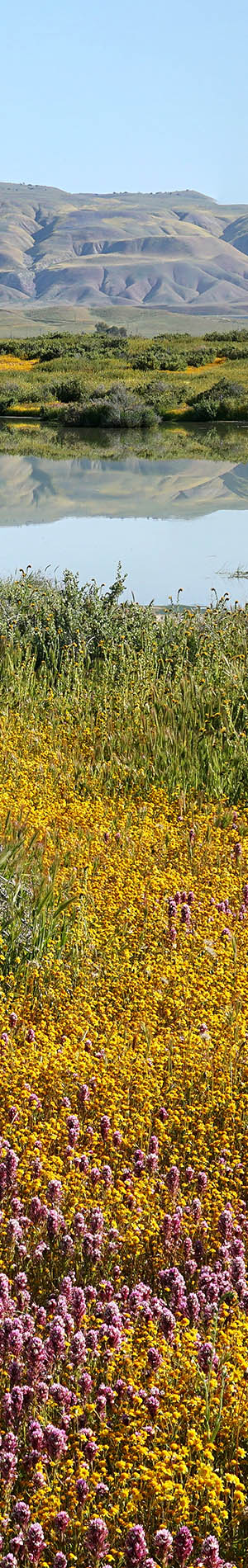
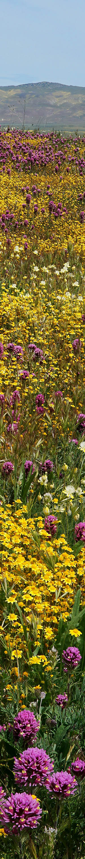
Overnight temperatures dropped into the low 40F's that by dawn Thursday April 11, 2019, caused extensive areas of ground fog. We would need to wait some for that to burn off. I took some photos of our camp spot per above right with my new tiny Canon ELPH900 compact digital camera. An hour after sunrise, the fog was rapidly clearing leaving mostly sunny skies and a slight breeze. Fearing stronger breezes, we quickly swung into action. The above was my second subject worked at 7:30am PDT towards the northwest. Our camp area was just on the other side of this hill so indeed we were in a densely covered flower wonderland. Poking over the ridge 3 miles distant in the background is the Caliente Range. The foreground short yellow hued flowers are goldfields, Lasthenia californica, while the magenta hued flowers are purple owls clover, Castellegia exserta, and taller yellow flowers are hillside daisies, Monolopia lanceolata. The perennial bushes are Mormon tea, Ephedra Californica. The fragrance of the recently risen goldfields dominated our world. Mixed in with the fresh flowers are darker yellow flowers that had risen up about late February.

SK07012-30 4000x6000 pixels 1 frame 19 image focus stack blend A6000 30mm
enlarged vertical slice view
A breeze was as expected increasing as I aborted half way through shooting another nearby subject. I went back over our small hill to shoot at 8am an exceptionally dense column of flowers per image above that was just 100 feet or so from my car.

SK07071-07114-2x1v 6300x6000 pixels 2 frame 2 column 1 row 44 image focus stack stitch blend A6000 30mm
enlarged vertical slice view
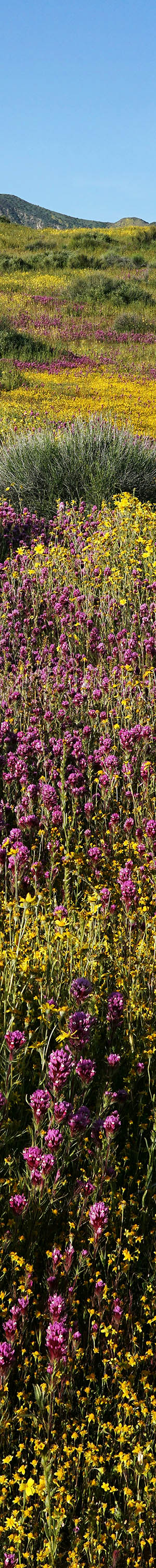
Back at my car, I removed some warmer clothes then set out south along the ridge line of our hills. There located the above subject with a foreground of purple hued tansy phacelia, Phacelia tanacetifolia, that colonized below perennial Mormon tea aka desert tea, Ephedra californica, that are about the only green plants in these small hills over most of the hot dry summers. The bushy ephedra provide cover for a list of small animals and birds, especially jack rabbits that we saw frequently and within its shade are some plant species that won't colonize open areas. There were just a few insect species yet hatched and active like butterflies.

SK07115-36 4000x6000 pixels 1 frame 22 image focus stack blend A6000 30mm
enlarged vertical slice view
With my medical issue noticeably improved, I had the confidence for a longer exploratory hike so ventured out east across Soda Lake Road to the base of a hill where I could look down at an expanse of valley phacelia, Phacelia ciliata, in the distance I call the "Purple Koolaide Lake". The lake was maybe half the size of what occurred in 2017.
2017 Trip Chronicles
In the foreground the small orange flowers are the ubiquetous fiddleneck, Amsinckia menziesii intermedia, while the white hued flowers are pretty creamcups, Plastystemon californicus. At frame mid ground is an interesting combination of fresh goldfields around large ephedra bushes and further east tall whitish California mustards, Guillenia lasiophylla. The brown areas are tiny gone to seed and drying California peppergrass. In the background, the Temblor Range yellow areas are hillside daisies. After our morning session with breezes ending further work, we passed our time the rest of the day lazily at our camp area, especially reading.

SK07264-72 4000x6000 pixels 1 frame 9 image focus stack blend A6000 60mm
enlarged vertical slice view
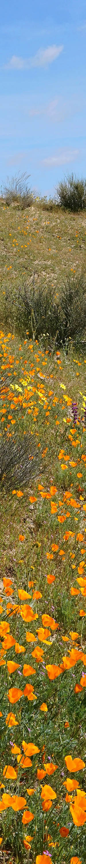
Overnight a northerly breeze was evident that waned some at sunrise Friday April 12, 2019. I went back to the shot I'd aborted from Thursday but just shot a couple frame before a too strong breeze returned showing it had always just been atop the cool pool of air often filling valley bottoms before sun warms up ground areas causing mixing. So for adventure, I rambled back out east hoping to find some close-up subjects. An orange hillside turned out to be California poppies, Eschscholtzia californica. The flowers were nicely spaced on what would normally be a rather harshly bright bare earth substrate. I moved around looking at what the flowers looked like and found at 9:30am the above partially backlit frame worth working. Backlit, the ground brightness was muted, the poppies glowed, the sky was a nice baby blue, and in the lee of the breeze direction there were enough partial lulls to focus stack the subject. Note also a few light yellow hued desert dandelion, filaree, blue hued chick lupine, Lupinus microcarpus, hillside daisies, and drying fiddleneck.

Back at camp we were in for several hours of leisure so out came the magazines and other diversions. With my Forester perpendicular to the overhead sun direction, placed a plastic blue tarp across my left side windows while opening the rear door. Temperature midday was ideal in the low 70s as I read several Time magazines. I would have preferred to have worked more close-up subjects midday during my week in the monument as there were plenty of flowers subjects to do so, however midday breezes were simply too strong to bother dealing with post processing mis-registration. Friend D drove off to Taft in order to restock some food and our cooler melted ice supplies. A fatal accident at the SR166 junction would have that road closed for hours so he had to take the long way back via SR58. Later in the afternoon at 5pm we hiked east and along our dirt road came across a couple Bakersfield legless lizards, Anniella grinnelli. A bit too impatient to set up and take a more serious shot plus the reptile's intent to escape off the road, I just took a few hand held shots, none of which focused well. The smooth skinned snake-like reptile did not like my holding him from wriggling away.

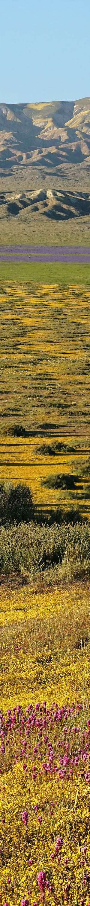
SK07306-07332-2x1v 6600x6000 pixels 2 frame 2 column 1 row 27 image focus stack stitch blend A6000 60mm
enlarged vertical slice view
By 5pm we were up on a hill with a foreground of owls clover, goldfields, and the best view of the distant Purple Koolaide Lake. It was a superior view to the one I had shot lower down the hill Thursday morning and the clear dry air provided a warm late afternoon light across the plains and Temblor Range. Nine people are in this view at ant like size. See the enlarged vertical slice view. Despite the wind on an exposed site, the wind lulled enough to still the foreground flowers. I particularly like the geometric graphic structure with this image, especially the dark ephedra clumps within a goldfield matrix and shadowing of distant mountain slopes. The immediate lower set of hills beyond the lake marks the San Andreas Fault. The higher mountains are the Temblor Range with yellow areas hillside daisies. There are few perennial plants on this arid side of that range that is mostly awkward to travel within eroded bare soil badlands. The east San Joaquin Valley side is a light California juniper and scrub oak woodland. On that east side of the Temblor Range is one of the largest petroleum and natural gas production regions on the continent.

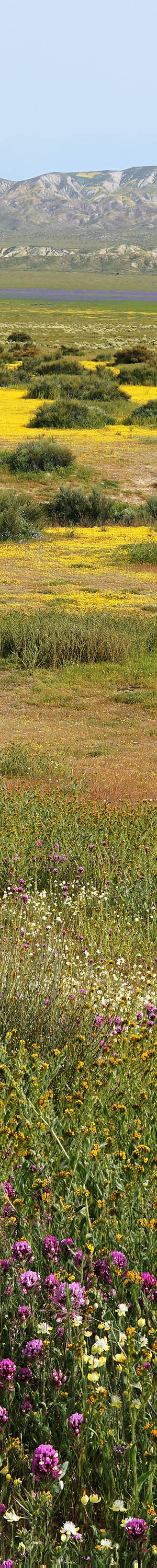
SK07370-07554-5x2v 14500x10000 pixels 10 frame 5 column 2 row 185 image focus stack stitch blend A6000 60mm
enlarged vertical slice view
Overnight the breeze ended providing some optimism on what would be our last morning in this zone of the monument. At sunrise Saturday April 13, 2019, I was determined to work the aborted shot yet again so at an early 6:30am was set up with my 60mm lens. Skies were sunny with an intermittent slight breeze. That took a half hour to shoot 182 shots in order to make a large 5 column 2 row 10 frame 14500 by 10000 pixel image. The foreground is all goldfields and owls clover with hillside daisies, fiddleneck, and cryptantha adding to complexity further back. After processing I had to concede the subject was not as strong as it seemed to be standing there. A prime reason was there are areas of past peak drying fiddleneck that are more prominent at high resolution. Additionally, the bright yellow hued, side lit goldfields don't have as much saturation impact as they do in person.

SK07650-60 6000x4000 pixels 1 frame 11 image focus stack blend A6000 30mm
enlarged vertical slice view
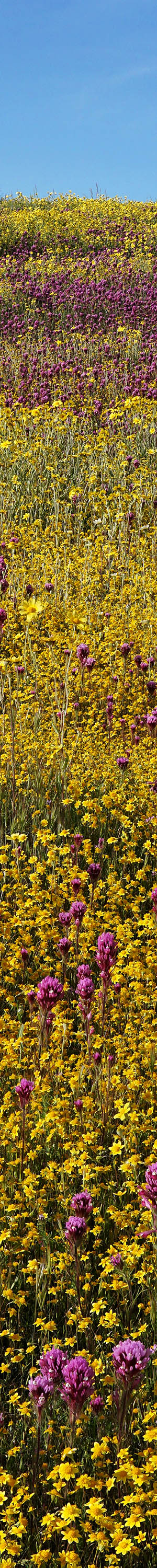
At 7:20am worked the above close-up with my Sigma 30mm F1.4 lens. A breeze was rising so did not waste time with my 60mm lens. Dense purple owls clover with goldfields at frame bottom and white fiesta flower, pholistoma membranaceum, at frame top.

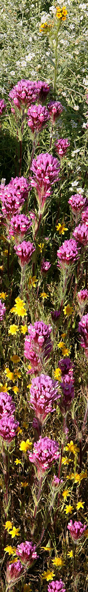
SK07661-07711-3x1v 9300x6000 pixels 3 frame 3 column 1 row 51 image focus stack stitch blend A6000 60mm
enlarged vertical slice view
At 7:30am I worked my last subject in our camp area looking down at a small patch of dense goldfields and purple owls clover. The intimate near subjects of owls clover and goldfields after processing proved to work better than the landscapes. Back at our cars, we packed up gear and then drove off on tour of nearby the dirt roads. If we had found some other good locations, we optionally could have stayed another night. Instead by late morning with a stronger breeze now blowing we were on our way north on the Soda Lake Road and then east on the dirt Panorama Road that brought us to Elkhorn Road at the base of the Temblor Range. At midday we stopped at a canyon I had hiked into previously that from the parking area looked past peak and drying. I hoped deeper in the canyon labyrinths we would find something worth shooting. First we made lunch amid several other cars passing an hour or so. I became a bit impatient with the situation so decided we should hike into the canyon even though the light was still harsh as I increasingly expected slopes would not be worth waiting for. Indeed over the next couple hours we found that to be the case. It looked like the peak had been a couple weeks earlier about the time I had wanted to visit after my second road trip.
Further north we continued to assess the color on the badlands slopes. It all was past peak and even roadside along Elkhorn Road flowers were greatly smaller in size with many bare patches versus 2017 when I waded through thigh high fiddleneck. Enough so that if I had driven through the monument as intended after leaving Antelope Valley on March 25, I would not have bothered making a road trip at that time and would have reported that to D. D did capture some nice shots at Antelope Valley but was marginally worth his long road trip. We continued north and at the location thousands of hikers had parked in 2017 and then climbed up into the colorful hills, we found NO TRESPASSING signs that I had been vaguely mentioned on a web board. I had actually talked with the pleasant rancher for about 15 minutes in 2017 and suspected there were legal reasons he had to do so. I had already come across two illegal campfire pits along dirt roads and some of those 2017 visitors had likely tossed trash. Of note despite the blocked access through the inholding property, there was still a convoluted legal way into those canyons that required more up and down across the canyon entrances.
We continued north past a long string of cars at the Wallace Creek Interpretive Trail San Andreas Fault parking area, then west on Simmler Road past Soda Lake, then north on Soda Lake Road to Seven Mile Road where we eyeballed from the dirt road where I had seen nice flowers on Wednesday. Then drove back west and onto a dirt road that led up into higher elevations with a secluded place we could park to overnight. There we set up for the night and made dinner. Discussions centered on what next as it did not appear the monument had anything more to offer us and that meant we might be heading home after minor explorations the next morning.

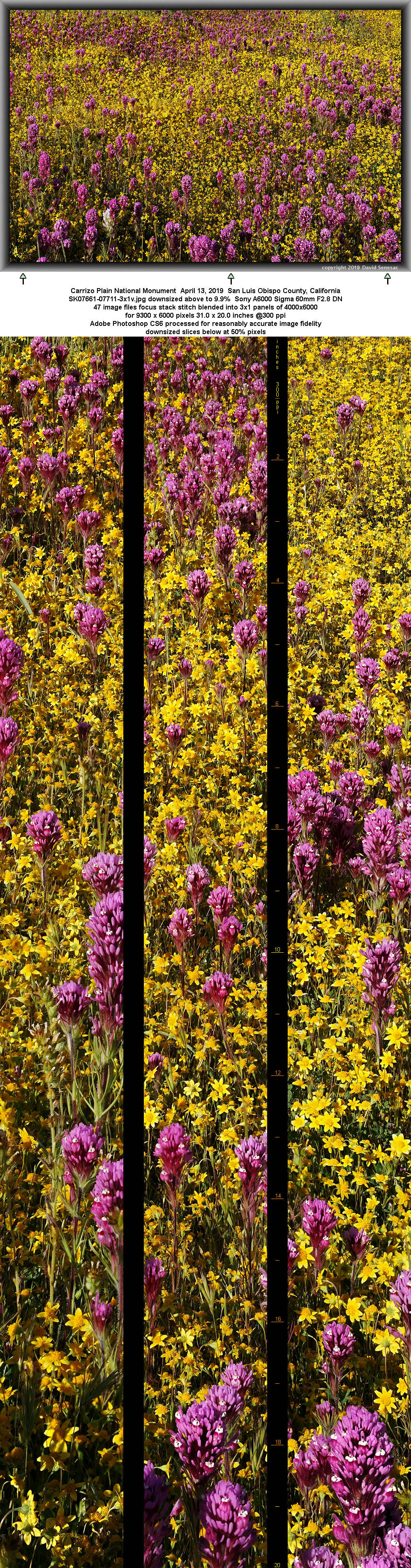
SK07809-07854-3x1v 9300x6000 pixels 3 frame 3 column 1 row 46 image focus stack stitch blend A6000 60mm
enlarged vertical slice view
At sunrise Sunday April 14, 2019 we drove off east back to Seven Mile Road, parked and walked around a short while. Although we found some modest subjects, it was not enough to keep D around so he drove off starting his road trip back to Colorado. I moved on to another area hiking a 2 mile plus loop. On the topo one can see numerous small ponds, channels, and marshy areas east of Soda Lake that continue for miles to south of Simmler Road. I came across a very shallow pond with hummock islands that did not have the usual perimeter of white alkali dust and mud. It looked like the whole area had benefited from extra recent rain much like where we had camped the previous few days. Since it was easily the calmest morning of the week, I was looking at excellent reflections. Water birds were enjoying feeding at one end of the lake. I first worked the above subject at 7:40am. Dense purple owls clover and goldfields reached right down to the water's edge along all shores. Unlike the hills we had camped at, down about these valley alkaline bottom lands, there were scattered saltbush and other salt tolerant shrubs without any ephedra. The shrub at frame left edge is a saltbush, Atriplex polycarpa. At mid foreground are areas of alien European grasses. Carrizo Plain due to alkaline soils, is one of the few places in the state where alien grasses have not been able to dominate our native plants. However all around this biological island are areas with alien grasses so they do find niche locations to colonize.
Three subjects later, worked the image at page top, a two wide horizontal stitch blend looking east northeast towards the Temblor Range. I don't structure many horizontal orientation stitches but there are subjects where that does work better. For this shot I needed to move just far enough back from the pond and at my full tripod height to get the background range in the reflection.m Dense areas of goldfields, purple owls clover, and fiddleneck with a few Fremont's tidy-tips.

SK08101-08135-2x1h 10200x6000 pixels 2 frame 2 column 1 row 35 image focus stack stitch blend A6000 30mm
enlarged vertical slice view
Exploring another nearby zone at 8:55am came across this marshy area next to what was decades ago an old levee road of which there are many in the valley where real estate was abandoned. Most of the cyan hued shrubs are again saltbush. The alkali mud is often deep and soft so needs to be carefully avoided rambling about. There are also many more alkali channels surrounded by white alkali mud shores that are especially treacherous and tend to block navigation routes. Given my light weight, I can gingerly walk out on some where the shallow surface is dry while being careful gently placing each foot down, testing how much I am sinking in. Pronghorn and elk on the plain play the same game as one can see where they have walked out then turned around lest they get stuck.

SK08136-08181-2x1v 6700x6000 pixels 2 frame 2 column 1 row 46 image focus stack stitch blend A6000 30mm
enlarged vertical slice view
Above image at 9:05am shows where another shallow pond had recently been and then dried up. The sun warmed drying top layer of the alkali mud contracts at a different rate than more moist mud below and that tension causes cracking and curling. Indeed, when I dug down into the dry surface, it was immediately moist below and one can see one spot just left of center frame where water is still at the surface. I thought this was particularly interesting with the bright yellow freshly blooming goldfields, Lasthenia californica, contrasting strongly.
An intermittent light breeze was increasing as I began to discover more shallow ponds without white alkali shores. Some were lush with flowers to shore edges, absolute gold mines of photography and all these subjects had probably never ever seen a tripod even in past springs because they are well away from roads and often not on the topo because they dry up quickly. I took some shots for the sake of insurance, however since light was becoming increasingly harsh, had decided to return early Sunday morning when light was better. Thus drove off back to the northwest side of the monument where I had wanted to explore a dirt road that continued west into ranch grazing lands. That proved productive as I found subjects to visit in the future as well as a fine location to disperse camp on what I expected would be my last night.

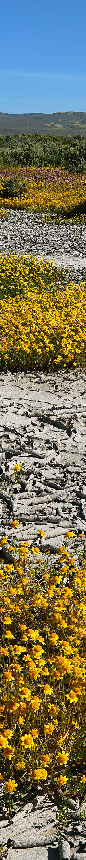
SK08251-08356-5x1v 15300x6000 pixels 5 frame 5 column 1 row 106 image focus stack stitch blend A6000 60mm
enlarged vertical slice view
A breeze developed overnight then waned some by sunrise Monday April 15, 2019. My plan this day was to rapidly work some of the pond areas I'd looked at Sunday and then a couple subjects near where I camped before heading home. Since some of the latter had poppies and creamcups, there was no need to be there until those species opened later in the morning, while the former couldn't be worked too early lest the flowers appear less vibrant and saturated with too many shadows. Thus sat on the above spot till an optimal 8:30am to shoot a big 5 column wide panorama with my 60mm lens. Many of the shallow ponds like this have odd shapes as they fill depressions in the landscape. Here I captured a channel separating two larger pond sections and expect these annual plants are from seeds of the big 2017 spring bloom.

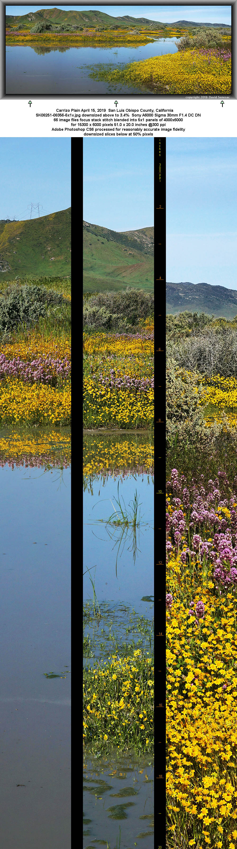
SK08365-08448-4x1v 12400x6000 pixels 4 frame 4 column 1 row 84 image focus stack stitch blend A6000 60mm
enlarged vertical slice view
With a pesky breeze increasing, my third and last pond subject this morning was a 4 column wide panorama with my 30mm lens. One will note a few blue hued flowers that are larkspur. My tripod height was rather low so flowers would protrude up against the pond waters but that also meant I had to accept the alien rye grass at foreground right.

SK08625-38 6000x4000 pixels 1 frame 14 image focus stack blend A6000 60mm
enlarged vertical slice view
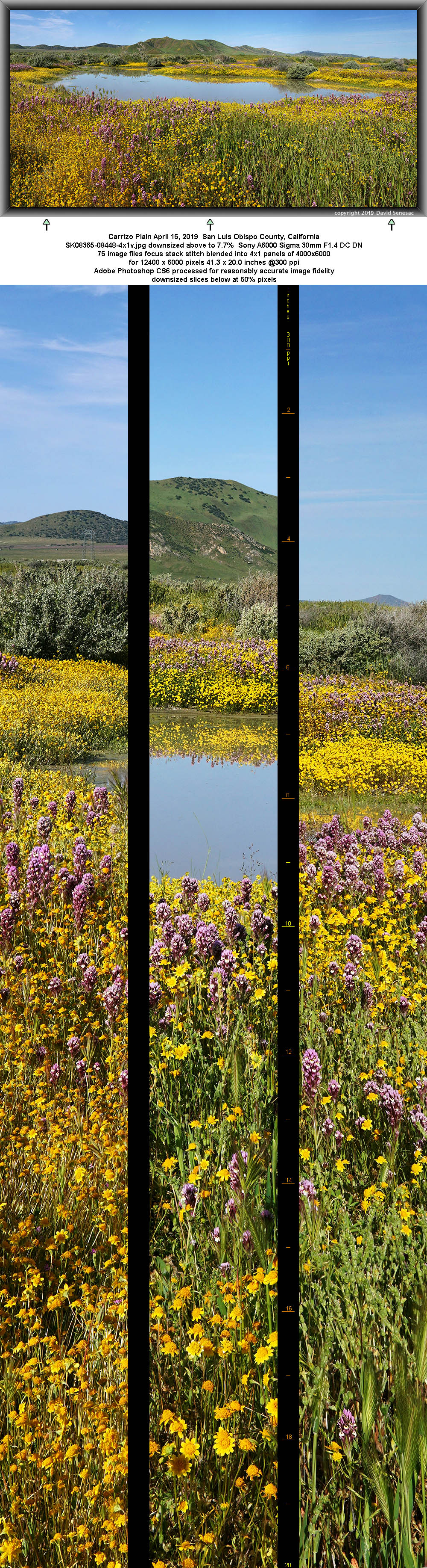
After driving back west I found creamcups opening slower than expected so wandered out to a large expanse of water stunted purple owls clover that I shot at a late 11am. Note the dry grass between the owls clover. Some taller deeper rooted California mustards, Guillenia lasiophylla, are at mid frame. In the distance in this backlit subject is Soda Lake and Soda Lake Overlook with a few vehicles parked against that hill. Midframe below visible level is a dry sandy wash with California juniper trees.

SK08685-05 4000x6000 pixels 1 frame 21 image focus stack blend A6000 60mm
enlarged vertical slice view
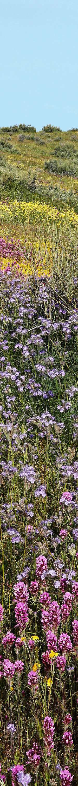
By time the creamcups opened the breeze had become strong enough that shooting anything was difficult as I aborted work on a couple subjects. I decided to stick with this one patch of dense flowers that then took 15 minutes while waiting for lulls to capture and a whole day to tediously process at home. Besides goldfields and purple owls clover, the foreground shows a few valley tassels, Castilleja attenuata and California poppy, Eschscholtzia californica with creamcups, Plastystemon californica, further back.
I drove further west while the most colorful sundog I've seen in decades was forming in high clouds above as the tail end of a front far to the north pushed through higher elevations of the atmosphere. After racing out to a spot to make a reasonable shot, it quickly disappeared as I regretted just taking a sky only shot. It was now high noon and I began my long 240 mile drive back north that ended my 2019 spring wildflower work.
NEXT: Page 5 South Fork San Joaquin River Backpack
2019 Trip Chronicles: Contents