
VH07323-07328-3x1v 6900x5600 pixels 3 frame 3 column 1 row 6 shot focus stack stitch blend a6700 17-40mm @40mm
enlarged vertical slice view image text section
NEXT: Page 2 Carrizo Plain National Monument 3/10
2026 Trip Chronicles: Contents
San Luis Reservoir Wildlife Refuge 2/13
Yosemite Valley 2/19
Hope Valley SR88 2/27
San Luis Reservoir Wildlife Refuge 3/3

During most winters, my primary focus is skiing at my 3 Epic Tahoe season pass resorts. The early 2025-2026 ski season received good early storms, but that accumulation melted away quickly from a following long warm dry period. As the Christmas New Years holiday period began, a series of large storms arrived that brought conditions to above normal precipitation levels. Many annual wildflower species from seeds in shallow ground, began their germination phases. I managed to ski 5 days in January before a 40 day exceptionally warm dry period caused an unusual very early rise of lower elevation annual species plants. The above chart shows precipitation at Hollister that is near the Pacheco Pass region where I made my first photography day visit of 2026 with the red dot that date, 2/13, and the blue dot a visit 18 days later per text further below.

VG06769-06799-4x1v 12350x6100 pixels 4 frame 4 column 1 row 4 shot stitch blend a6700 56mm
enlarged vertical slice view
The above image is west southwest from Dinosaur Point Road into the, closed to the public, zone of eastern state park lands that shows the towering new wind turbines, nearly 600 feet tall, that replace turbines a tenth that size and will provide 9 times as much clean energy. Below right is a 100% pixels crop showing two tule elk, Cervus canadensis nannodes sitting on grassy slopes a bit left of the right turbine, where they spent their night. Open the enlarged vertical slice view link below the image, then press +, to appreciate how giant the new turbines are compared to oak trees below.

Paula Fatjo of Los Banos, the great-great granddaughter of Francisco Pacheco, donated the land to California in 1992, the year she passed at age 72, to be a park for future generations who share her love of animals, horseback riding, history, and unspoiled land. This land had been a horse and a cattle ranch since 1843. Thank you Paula for saving these wonderful natural landscapes!
On the supposedly unlucky day of Friday February 13, 2026, a bit after sunrise, I drove the 60 miles south to Pacheco Pass along SR152 and visited the San Luis Reservoir Wildlife Refuge that is just south of Pacheco State Park. I was surprised to find the above massive new additions to the wind farm within the state park. Construction was ongoing with significant eastern areas of the state park closed off. Each late winter, within the San Francisco Bay Area region, the first annuals tend to rise in that refuge within a narrow belt that is above chilly San Joaquin Valley ground fog and below cool marine air of the Coastal Range blocking crest just west.
There are other nearby similar landscapes within that belt, however they are cattle ranching blue oak savanna areas where there are few annual wildflower species seeds as is the case with most cattle grazing lands, while most of the park was an area with limited grazing. Cattle are effective at reducing alien grasses in areas where native wildflower species are more abundant, however over decades, species decline. Generally throughout California, native wildflower species have been far more affected by the spread of alien Eurasian grass species Spaniards brought with them for cattle feed.
As a lower gap in the Coastal Range, cool, heavy marine air concentrates flowing through the pass gap into the warmer air of San Joaquin Valley thus the location of the wind turbine farm. But that also tends to make the state park breezy during which I cannot take focus stack images. So during any days I might visit, I look at wind weather forecasts. As expected, only minor numbers of earliest wildflowers had risen, so I expected to take just a few modest photos, on this day for primarily assessing conditions. I parked at the 1100 foot level of Dinosaur Point Road, then hiked cross country down the blue oak savanna grasslands to familiar areas.

VG06892-14v 4100x6150 pixels 1 frame 23 shot focus stack blend a6700 17-40mm @40mm
enlarged vertical slice view
My first subject above at 10:19am PST with blue skylight illumination, on a steep slope beside a bulldozed refuge dirt road, was the unusual trentepholia algae, with lichen on a small, shaded, dormant, California buckeye, Aesculus californica, trunk. Trentepohlia aurea is a species of filamentous terrestrial green algae, that is occasionally at Pacheco Pass on ridge line shady trunks and is only at the above bright red stage for limited periods after heavy winter storms. It always grows in association with various crustose lichens. Behind the tree is a lush dewy mix of miner's lettuce, Claytonia perfoliata,, and California manroot, Marah fabaceus, both still with very few blooms, that are small white flowers. On moss are some common polypody, Polypodium calirhiza, ferns. Behind the buckeye with a few new leaf buds poking out is a newly rising with new red leaves poison oak. Poison oak is common in the zone within stream ravines where one must be careful rambling about. An impossible shot at a low F8, narrow depth of field, without my a6700 focus bracketing. Open the enlarged vertical slice view link to appreciate how glowing bright the algae is.

VG06965-85v 4100x6150 pixels 1 frame 21 shot focus stack blend a6700 30mm
enlarged vertical slice view
At 10:52am, worked this image of a California newt, Taricha torosa. During late winter after storms, these newts can be found about ephemeral streams. Although slow moving, they tend to be difficult photographic subjects as they attempt to crawl away. Here the little cartoon like form amphibian was blocked by a marine sedimentary rock overhang that allowed me to run off a set of 21 focus stack shots within the short few seconds the a6700 automates that formerly multi-minute process, a boon for this photographer's work. The bright orange color warns possible predators that it would be a poisonous meal. Their only predators are garter snakes. Glands in the skin of taricha torosa secrete a potent neurotoxin tetrodotoxin, which is hundreds of times more toxic than cyanide.

VG07121-40v 3800x4700 pixels 1 frame 20 shot focus stack blend a6700 17-40mm @40mm
enlarged vertical slice view
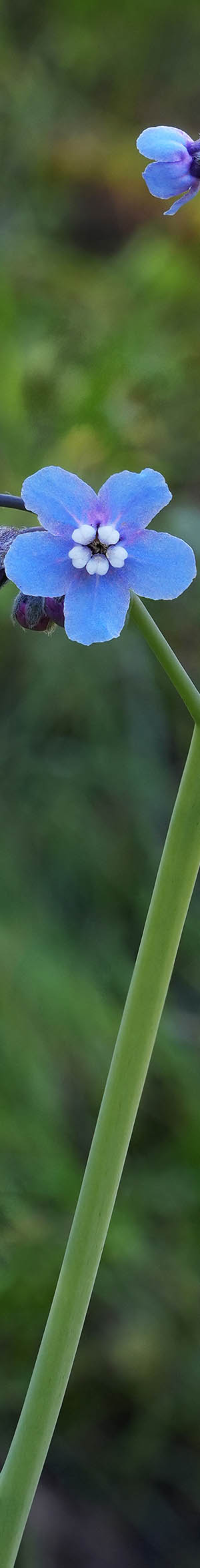
After considerable more landscape wandering while increasing breezes prevented any more work, at 11:52am down in a breeze protecting stream ravine, worked this hound's tongue, Adelinia grandis, plant with its beautiful blue flowers. I spent quite awhile, trying to work this sparse species that tends to rise in late winter, that the breezes kept moving. At the great magnification level of the a6700, even slight movements cause focus stack mis-registrations that must be tediously worked out with Zerene Stacker in post-processing. With close-ups, anything more than slight movement is impossible to fix.

The long warm dry spell ended with an exceptionally cold storm series that forecasts predicted, Yosemite Valley at 4,000 feet, would receive a significant amount of uncommon snow since average snow levels are about 6,000 feet. Although I could have chosen to ski uncommon very light low water content fresh powder snow, snow in YV is even less common, so decided to do a trip to the park instead. Thus before the usual horrific week day commute traffic on the early afternoon of Wednesday February 18, 2026, drove the 170 miles to the McCabe Flat BLM campsite. The remote campground along with 2 others, are along a dirt road beside the Merced River, where I would be staged to drive into the valley as the storm that began on February 16 waned. The $20 campground fee station was out of pay envelopes.
Although earlier periods of the storm had brought snow down on the SR140 highway along the river below 2000 feet, the snow had already melted due to warm ground temperatures. So the only snow-covered roads I would need to negotiate were up in the park above 3000 feet. The NWS Yosemite Village weather site during the storm, recorded 2.3 inches of precipitation with temperatures below freezing that equates to over 2 feet of snow.
Early dawn Thursday February 19, 2026, was up in the dark, moved gear around, drove the 30 miles east on SR140 to El Portal, and to the park's unmanned entrance station. Was wearing a full set of older, water and snow proof ski clothing including my old Sorel Caribou boots. Digital signs down at El Portal said something about the park being closed that had been true the day before during the storm. Others ahead of me passed right through, and so did I. Further up the river canyon was increasing areas of snow. I wanted to first take some photos from the Yosemite Creek bridge looking up at Lower Yosemite Falls before any sun reached the top of those falls. That required a 1/3 mile walk from the loop road at Yosemite Lodge. Walking around anywhere was tedious, much less parking a vehicle.

VH07175-78h 7600x3000 pixels 1 frame 4 shot focus stack blend a6700 17-40mm @40mm
enlarged vertical slice view
Due to damming snow, parts of the trail were under shin to knee deep water. So I wasted a lot of time trying to hike around the deep spots and by time I reached the bridge at 7:45am PST, harsh sunlight was already bright on the falls making that subject useless. Wearing my snow shoes would have worked much better. Instead per above, I worked a single modest shot of the amazing light green snow slurry filled Yosemite Creek that I had previously seen like that in 2006. Atop the water was a floating broken mass of white snow/ice chunks with a olive greenish brown channel cutting through that frequently formed and reformed in changing ways.

VH07197-98h 6150x4100 pixels 1 frame 3 shot focus stack blend a6700 17-40mm @26.5mm
enlarged vertical slice view
Back on the loop road, I drove west to El Capitan Meadow, parked, put on my Tubbs snowshoes, then hand carrying my big tripod with my new $1k Sigma 17mm>40mm DC ART lens, followed a cross country ski skinning track out along the Merced River edge. My second subject of the day at 9:00am was the above single frame winter wonderland like shot of snow covered limbs of winter dormant deciduous willow tree branches in sun against a still shaded background of Lower Cathedral Rocks. Nicely, calm conditions left snow on all manner of trees and rock surfaces, however that quickly ended as sun melted snow, including frequent loud icefalls coming down cliffs.

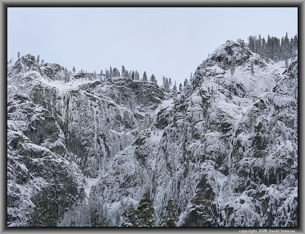
VH07203-07209-3x1v 8500x6100 pixels 3 frame 3 column 1 row 7 shot focus stack blend a6700 17-40mm @17mm
enlarged vertical slice view
This second shot at 9:17am, a 4 frame stitch blend, from the south side of El Capitan Meadow is of El Capitan rising over 3400 feet above its meadow, one of the most awesome cliffs on planet Earth. Note the ski track in the shadows. The famous Horsetail Fall firefall is on the right side of the image barely dribbling a bit over the cliff edge because the exceptionally cold air from the storm froze most of it. Visitors that had come for that event came up empty as the previous week had often been cloudy or stormy.

VH07214-15v 4100x6000 pixels 1 frame 3 shot focus stack blend a6700 17-40mm @19.4mm
enlarged vertical slice view
Driving further west on the loop road, stopped at 9:52am for this above across the river viewpoint of leaping out 620 foot, Bridalveil Fall, just a 3 shot focus stack as my foreground was at a distance from my tripod along the road. Notice how dark the river water is in these shots that is how it really appeared due to bright adjacent snows and the phenomenon of total internal reflection while the sun is at lower sky altitudes. At frame center is Leaning Tower with Dewey Point at 7385 feet to its right. While rising over the range, thin clouds were forming, while temperatures during the morning were a bit below freezing.

VH07217-07219-2x1v 5200x6200 pixels 2 frame 2 column 1 row 4 shot focus stack stitch blend a6700 17-40mm @28.8mm
enlarged vertical slice view
Driving back around on the loop road to the Bridalveil Fall loop road pull out viewpoints, at 10:10am had some better light including some blue sky above. Dormant lower frame trees are black oaks.

VH07223-07225-3x1v 8100x6200 pixels 3 frame 3 column 1 row 4 shot focus stack stitch blend a6700 56mm
enlarged vertical slice view
Continuing around the loop road then back around to the popular Bridalveil Fall loop road pull outs, at 10:18am, worked the above 3 frame stitch blend with my 85mm Sony prime lens of North America's tallest waterfall at 1612 feet, Ribbon Falls, and its impressive, rare adornments of snow on cliff and trees. With its small drainage basin above mostly frozen by the cold conditions, water only mostly dribbled down its dark wet rock that is much more visible after selecting the enlarged vertical slice view, showing far more actual detail even at 50% pixels.

VH07232-07233-1x2h 6100x6000 pixels 1 frame 3 shot focus stack blend a6700 85mm
enlarged vertical slice view
By 10:45am had driven east to the large open views across the river from Yosemite Lodge where I worked several subjects with this first above, a two frame horizontal 85mm lens stitch blend of nicely aesthetically snow covered North Dome with Royal Arches below. With sun warmed air rising up from the valley floor, forming clouds were swirling up along cliff faces.

VH07234-07238-4x1vb 5800x6100 pixels 4 frame 4 column 1 row 5 shot stitch blend a6700 85mm
enlarged vertical slice view
This next image above of Yosemite Point with dramatic swirling clouds forming in front of its 3000 feet wet rock face, is a crop version of a larger unbalanced 4 frame stitch blend image towards frame right. Arrowhead Spire is mostly obscured.

VH07241-07246-6x1v 16600x6000 pixels 6 frame 6 column 1 row 6 shot stitch blend a6700 85mm
enlarged vertical slice view
The above 6 column 85mm stitch blend at 16600 pixels by 6000 pixels at 11am, was the largest image of the trip, showing the Indian Creek canyon to North Dome panorama. Much fine detail of uncommonly snow covered trees and rock in the full image.

VH07249-07252-3x1v 8600x6200 pixels 3 frame 3 column 1 row 4 shot stitch blend a6700 56mm
enlarged vertical slice view
Mounting my Sigma 56mm prime, probably my sharpest lens, worked this 3 frame stitch blend of Upper Yosemite Fall with Eagle Tower at frame left and Yosemite Point at right. Although my morning had begun disappointingly, I had by late morning captured some Yosemite Valley in rare snow images that made the trip and effort worthwhile.

This above 100% pixels crop at F5.6 from the above 8600 by 6200 pixel full VH07249-07252-3x1v image, shows the fine detail of the top of Upper Yosemite Fall. With harsh midday light limiting work, I drove to Yosemite Village to straighten out gear and at the village store, bought a delicious turkey and cheese sandwich.

VH07264-07269-3x1v 9300x6100 pixels 3 frame 3 column 1 row 6 shot stitch blend a6700 a6700 17-40mm @31.1mm
enlarged vertical slice view
By 1:30pm was back on the loop road where at 2:06pm was on the Leidig Meadow foot crossing bridge working this 3 frame stitch blend monocolor image up the river towards Upper Yosemite Fall. Skies had become cloudier, that left Merced River waters reflecting dark wet rock and tree elements contrasting with bright white snow.

VH07274-07285-2x1v 6600x6100 pixels 2 frame 2 column 1 row 12 shot focus stack stitch blend a6700 a6700 17-40mm @21.1mm
enlarged vertical slice view
I drove around the loop to the popular Valley View pullout viewpoint that had not had any parking available earlier, where I managed to luck out this time as someone pulled out. Thus at 2:40pm set up a 3 frame stitch blend image at of the classic El Capitan to Leaning Tower panorama. This particular viewpoint was from down along the river edge where others had for hours been beating a slippery worn path in the snow. Unfortunately, my right frame image set did not focus at infinity well, that happens sometimes for unknown reasons in the a6700 Focus Bracket mode, spoiling the image. On important images, I sometimes after shooting a set will take an extra manual infinity focus shot. So, the above 2 frame panorama with Lower Cathedral Rock at frame right, doesn't include a third frame at right with Bridalveil Fall.
At page top, is a view at 2:58pm, of the Merced River at Valley View foreground with Cathedral Rocks, Bridalveil Fall, and Leaning Tower. Its third frame at right, also didn't infinity focus well, so has mostly been cropped out.
VH07350-07354-3x1v 7900x6000 pixels 3 frame 3 column 1 row 3 shot stitch blend a6700 a6700 85mm
enlarged vertical slice view
The above at 2:58pm, is an 85mm medium telephoto of the shaded Stanford Point ridge line section showing how unlike the south facing Yosemite Valley cliffs, almost all the snow at 2:40pm remained on these areas without any sun and temperatures well below freezing.

VH07355-64v 4100x6150 pixels 1 frame 9 shot focus stack stitch blend a6700 a6700 17-40mm @32.4mm
enlarged vertical slice view
Driving west into the Merced River Gorge, stopped at 3:22pm to work this about rapids section.

VI07411-07422-2x1h 3800x4700 pixels 2 frame 2 column 1 row 20 shot focus stack stitch blend a6700 17-40mm @28.5mm
enlarged vertical slice view
On my drive home on SR88 from a couple days skiing at Heavenly, on Friday February 27, 2026, stopped at a Hope Valley location with these dormant willows showing the melting snow scene after one of the longest winter dry spells. Note how the snow surface is also showing a pattern of suncup formation that one normally sees only during summers.

VJ07509-07524-2x1v 6900x6200 pixels 2 frame 2 column 1 row 16 shot focus stack stitch blend a6700 17-40mm @22.2mm
enlarged vertical slice view
On a day with calmer breezes, again drove the 60 miles south on Tuesday March 3, 2026, and revisited the same blue oak, Quercus douglasii, savanna areas I'd explored at San Luis Reservoir Wildlife Refuge 18 days earlier. A modest bloom of wildflowers were now about. Here above, with Padre's shooting stars, Primula clevelandii, California golden violet, aka johnny-jump-ups, Viola pedunculata, blue dicks, Dipterostemon capitatus, and San Luis Reservoir peaking through branches. The shooting star species was formerly Dodecatheon clevelandii, however since the recent rise of genetic science, some species upon DNA analysis have been placed into different genus and species.

VJ07525-30h 6150x4100 pixels 1 frame 6 shot focus stack blend a6700 17-40mm @17mm
enlarged vertical slice view
Above image of a blue oak, Quercus douglasii, trunk and branches. Blue oak is the most common oak species in the Pacheco Pass region as well as many foothill areas of the north state. This deciduous species has just leafed out with light green leaves. As a single digit kid, I climbed these oaks more than any others.

VJ07539-58h 6150x4100 pixels 1 frame 10 shot focus stack blend a6700 17-40mm @28.8mm
enlarged vertical slice view
Dense wildflowers with blue dicks, Dipterostemon capitatus, California goldfields, Lasthenia californica, white plectritis, Plectritis macrocera, tomcat clover, Trifolium willdenovii, plus moss and lichen on the marine sandstone outcrop.

VJ07620-48h 5400x4100 pixels 1 frame 29 shot focus stack blend a6700 17-40mm @33.4mm
enlarged vertical slice view
Close-up of live forever, Dudleya cymosa, and moss on a marine sandstone boulder plus some miner's lettuce and lichen on a fallen blue oak branch.

VJ07757-79v 4100x6150 pixels 1 frame 23 shot focus stack blend a6700 17-40mm @33.4mm
enlarged vertical slice view
Intimate image of filaree and grass in front of lichen on a marine sandstone boulder.
NEXT: Page 2 Carrizo Plain National Monument 3/10
2026 Trip Chronicles: Contents