
SB05490-05525-3x1v 9300x6000 pixels 3 frame 3 column 1 row 36 image focus stack stitch blend A6000 30mm
enlarged vertical slice view image text section
NEXT: Page 9 20 Lakes Basin Backpack
2018 Trip Chronicles: Contents
Humphreys Basin Backpack 7/31
Humphreys Basin Backpack 8/1
Humphreys Basin Backpack 8/2
Humphreys Basin Backpack 8/3
Humphreys Basin Backpack 8/4
Humphreys Basin Backpack 8/5
Humphreys Basin Backpack 8/6
Humphreys Basin Backpack 8/7
After the mediocre results from my summer 2017 backpack into Humphreys Basin due to considerable Mexican monsoon weather, I had made plans to return. Additionally my brother J had strong interest in a trip into the basin but due to work commitments was unable to do any trips last year. Thus over the winter made plans for a return group trip in 2018 that by early May was set for the beginning of August when I expected greenery and wildflowers would peak. After a wet May, June was relatively sunny, warm, breezy, and dry that moved up the vegetation cycle a week or two. By July another brother M committed to the trip. My original itinerary had been for a 9 day 8 night trip, however the North Lake trailhead for Piute Pass is one of the most popular quota trailheads in the range and was already fully reserved. Without a trailhead permit reservation, we planned to secure a mid week walk up permit a day before entry that would require wasting the first day just to obtain a permit and reduce our trip days to 8 requiring an itinerary change I had some doubts the others were fit enough for.

On July 13 a large probably human caused fire started near Savage Trading Post at the South Fork of the Merced River confluence that was putting large amounts of smoke into the California atmosphere including at times where we would be backpacking into. A week before our trip, weather information showed we had a good chance of escaping most of the smoky skies as forecasts showed winds blowing most of that smoke to the northeast. Also a week before our trip, severe monsoon thunderstorms that remained stationary for hours over eastern crest areas, caused a number of trail and road washouts including highway SR168 above Aspendale that would block access to our intended trailhead. A couple days before we left, Caltrans with considerable effort was able to open closed roads that was great news to Eastern Sierra businesses and visitors.
Sunday a warm morning July 29, I drove up north to pick up the others, and by afternoon was on the road through the Delta with considerable mid level smoke haze above from not only the Ferguson Fire but also an even larger horrible blaze in Mendocino that had just broken out. We drove up US50 over Echo Summit and then on SR89 to SR88 and into Nevada at also smoke hazy Gardnerville where I filled up on much less taxed cheaper gasoline. Mid level skies were smoky and became worse as we continued south on US395, peaking about the Mammoth Lakes region where we could not see much of the nearby mountains. In order to help acclimatize, I drove up to higher elevations to overnight. Smoke had been less dense as we went south of Mammoth.
Monday July 30 we were up at dawn and soon down in Bishop where an hour early, we established a third position in the growing line, confident we would easily fit into the remaining 12 unreserved slots available. At 8am the line of maybe 20 all signed in for the coming 11am next day list after which we drove to shade in the town's fine city park where we bored ourselves over another couple hours while outside temperatures increased towards the forecast 100F. Under sunny skies, smoke haze was lower and wind analysis at windy dot com had shown daily breezes would occur each afternoon pushing any smoke in the Owens Valley north towards Mammoth. Additionally a few days of Mexican monsoon weather was forecast to push from the Great Basin in over the Sierra that could also help remove smoke and haze. At 11am we indeed received our permit within a much more crowded visitor center. After a trip to Vons for food and drink supplies with a day to pass the time during, it was time to escape Bishop at 4k elevation up SR168 to much cooler 9.2k below Lake Sabrina. By mid afternoon weak thunderstorms built up over crest areas that only sprinkled our position while more usefully helped to clear out what had become a decreasing smoke haze. By late in the day, we readied our packs then hiked out a short ways to a location to overnight outside the dispersed camping zone while not within the John Muir Wilderness boundary.

As dawn rose on Tuesday July 31, 2018, we were soon packed up and on the steep rocky trail from the 9.3k campground with the first target Loch Leven Lake at 10.7k. The first few hundred feet of the heavily used horse trail are within lodgepole aspen forest with the cascading North Fork of Bishop Creek moving in and out of ear shot range. A wise time for this stiff hike as the early morning sun is still blocked by the tall metamorphic Piute Crags. Stopping briefly frequently on any available threesome sitting boulders or logs we eventually topped out beyond the rusty talus slopes then stopped beside that lowest lake. As expected the mosquitoes were few, only a minor nuisance about mushy seep areas. And on following days of the trip, I only bothered to put DEET on wrists and face a couple times.
Continuing on, by mid day we reached our destination at the west end of Piute Lake at 10.9k where we set up in a well used site below shading whitebark pines well away from the trail and the lake shore. Given my considerable photography field work earlier in the year and daily 50# weighted stair climbing before the trip, I was in better shape than my two brothers so set an easy pace accommodating their fitness levels. At our new camp zone while initially setting up my tent, I immediately became aware of a foul smell as some lazy inconsiderate recent users had apparently chosen as their latrine site just 20 feet or so from the main tenting spots. Our water source was directly from the lake's inlet stream draining areas of the pass basin that still held small areas of snow and through which the trail passed, an indication of how unconcerned this person is about the need to filter.
On my old MSR Whisperlite, cooked up an enjoyable Knorr broccoli cheese rice dinner. The forecast monsoon cumulus had developed training cells from the southeast over the canyon that had us escaping to nap in our tents mid afternoon hours while lightning zapped the nearby ridge lines and thunder echoed loudly off its massive bedrock walls. And tentbound in my Big Agnes Copper Spur HV UL1 atop a Thermarest NeoAir warmly below my Pinnacle goose down bag, that also allowed me to start working down on my considerable food supply including Italian dried salami and delicious Holland aged Gouda cheese that I wrapped into a supply of doughy wheat flour tortillas. I carried 12 pounds of a good variety of food, especially snacks and candy, that we consider key to an enjoyable backcountry experience that novices often neglect as they focus on reducing weight.

The narrow canyon bottom between 10.8k and 11.2k with nice groups of timberline whitebark pine beside tall craggy ridge lines that attract most lightning bolts is my choice of the best east side canyon to safely experience thunderstorms as long as one sites away from obvious terrain knees. The canyon is arguably one of the most aesthetic east of the crest with numerous small lakes and ponds for reflections, cascades over bedrock, lush wildflower meadows, gnarly avalanche shaped walls, craggy ridge lines, and the impressive rusty hued Piute Crags below. At dusk off my tiny SandDisk Sansa Clip+ MP3 player on a 20.5 ounce Bose Colorlink II speaker, bathed our camp zone in Gy Ligeti's Requiem from the 2001 Space Odyssey sound track, the incredibly eerie choral sequence when astronauts visit a Moon site with the imposing alien obilisk.
Link to acme.mapper Topographic map at Piute Pass.
As morning sun reached our upper canyon landscapes on Wednesday August 1, 2018, we had packed up and were slowly moving up the trail towards the pass just 500 feet above. Considering their limited fitness preparation as J struggled to cope with work commitments in his business, both J and M had done well reaching our Tuesday site. My carrying weight was about 63 pounds including about 16 pounds of photo gear that included 4 lenses and 22 NP-FW50 batteries each of which were 1.6 ounces. J with more fishing and cooking gear for the first time actually had a few more pounds carrying weight than I while M with extra unweighed food, labored with a weight in the low 50s. Moving slow again stopping frequently per my style, we 3 pilgrims reached the pass mid morning that was a relief to this person because there had been pre-trip concerns it would be too much for M while J had potential loose cartilage knee issues.
A bit below the top, I set up to take the modest panorama below with Summit Lake reflecting a slightly hazy light cyan blue sky color. All geology in this landscape is granite. Areas are barren of trees due to occasional high winter winds and cold winter temperatures. Where trees do exist, they are stunted and during winter are usually below the snow depth thus out of wind. On the skyline at center at 7.5 miles distance, iare The Pinnacles. To its right is Pilot Knob. We would not get any further this day than 1.75 miles as a bird flies to the forested area shown in front of Pilot Knob. The trail can be seen at frame right traversing well above Summit Lake. Below it, one can also make out an older unmaintained trail through the meadow beside the lake. However decades ago, such meadow horse trails were abandoned throughout the range because they tended to created deep trenches. In this case the trench is still rather deep and I suspect will still be there decades from now. Difficult to see around the lake in this considerably downsized for web image are three aerial winter snow survey towers

SB05061-05091-5x1v 14300x6000 pixels 5 frame 5 column 1 row 31 image focus stack stitch blend A6000 SELP1650 @49mm
enlarged vertical slice view
From the pass we continued following the descending traversing horse trail above treeless Summit Lake onto the expansive Humphreys Basin tundra then at 11120 I vectored away into a cross country route. That brought us through 3 impressive small wildflower short bunchgrass meadows I would work on Friday. We then entered an unusual jumbled moraine and boulder plain with sparse whitebark pine, the vigorous outlet stream from Lower Desolation Lake flows through. The lumpy up and down boulder landscape was the highest timberline area with whitebark pines where we might find shade. Although our destination this day had been Paris Lake on the other side of Carol Col, another 700 feet and 3 miles ahead, both M and J were not going any further. I had expected such so then described what our trip alternative itineraries could be that included base camping 2 or 3 nights at the excellent central location within the basin we now were at. That would remove our 3 days about the French Canyon Puppet Lake bench where we might have enjoyed better fishing. Given probable storms and smoke limiting usable shooting hours with decent light and photography subjects I was already was aware of on this side of the basin, that was fine. We were about 3/8 a mile below Little Desolation Lake where due to the awkward bouldery landscape, very few others choose to endure passing through much less camp within. A classic example of the kind of obscure ignored camp siting, I on my 201'st Sierra backpacking trip over 4+ decades tend to target for wilderness seclusion.
After dropping our heavy mule loads, J and I spent a surprisingly frustrating hour rambling about looking for a decent location to base camp. Well most of the sparse whitebarks we sought for tent shade were atop boulder piles that did not offer flat tent spots. Eventually we found a great camp zone with fine views among large boulders though tent shade was limited. But then given the cloudy monsoon weather, that did not become an issue. There were many small ponds among the jumbles not shown on the topo that had doubtless been dry during the recent drought years and obviously been refilled by all the monsoon rains.

Cumulus had been steadily building up over the crest. Tent up, I rambled off to the Desolation canyon stream to fill my 32 ounce Nalgene and 70 ounce Platypus while also taking a quick refreshing dip in the rigorous Desolation stream that had an abundance of pan sized golden trout. As someone that infrequently has breakfast with a main daily meal at lunch, I cooked up a quite delicious Mountain House beef stroganoff with mashed potato freeze dried dinner. Dark clouds with thunder moved over Piute Pass then sprinkling, that soon turned to rain chasing us into our tents for the following couple hours. J began calling our camp zone Marmotville as there was an abundance of those pleasant furry critters everywhere including at least 3 at our camp. Additionally were numbers of little belding ground squirrels, occasional chipmunks, and ever raucous Clark's nutcrackers landing atop the big clump of trees above M's tent. The marmots didn't seem to mind our presence as long as we continued to not have interest in getting too close to them. We were probably the first humans they had ever encountered and tended to laze about for hours atop boulders like the two in the image above. They also seemed to take the loud thunderstorm weather calmly, only bothering to leave their perches when rain began. Unlike those habituated in areas campers frequent, they did not rummage through our gear when we left our camp site. Two belding ground squirrels fought over a spot I P'd on for the salt and would warily approach within a few feet of where I quietly sat in shade mid day. Observed the resident making a teeth baring, chattering buzz towards his neighbor.

Late afternoon after thunderstorms seemed to move away so we went off exploring our realm. I took the above image at a nearby pond then returned to a vibrant green meadow we passed along our route only to be chased back to camp as another weak storm visited. After our strenuous day, we retired into our tents early again before sunset enjoying a long night of rest.

We enjoyed leisurely rising Thursday August 2, 2018. With cloudy monsoon weather at daybreak, I was not going to be doing any photography. I was surprised to see black thunderstorm skies off to the west above the main South Fork of the San Joaquin River canyon. To the east along the Sierra Crest and Mount Humphreys were minor showers. I moved my tent down to a more lightning safe hollow beside large boulders. Our tents were about 50 feet apart, each with our little gear zones. After breakfast the three of us got day hiking gear together and headed off up to Little Desolation Lake to fish. J was now limping some due to his knee issue. On my first cast, hooked a pan sized golden trout that I shook off at the shore. After that each cast with my old spinning reel grabbed line loops as line left the spool creating tangles. I found the level winding gear had broken. Instead of fishing, I spent a couple hours taking apart then reassembling the reel mechanism without success as gear teeth were worn.

By late morning showers from storms off to the west began pushing up the Piute Creek canyon threatening our area. M who doesn't fish had returned to camp after venturing up the creek while J unsatisfied with the shallow lake with pan size trout had climbed over the modest ridge and down to treeless expanses of Mesa Lake about a mile away to fish. With the approaching storms with increasing lightning thunder over French Canyon, J had little time to fish and instead was in a life threatening panic to leave his very exposed area thus moved as fast as a gimp could wisely cresting the ridge where he could drop into the shallow Desolation Lake stream canyon and then following that down back to our camp. The jumbled landscape of our camp zone wasn't easy to make sense of as he overshot our area some before swinging back just as the first strong storm with heavy rain and some hail hit. A train of storms continued over the following few hours with one particularly strong storm delivering 3 nearby large flashes followed quickly by especially loud long lasting thunders.

SB05282-05330-4x1v 8000x4000 pixels 4 frame 4 column 1 row 49 image focus stack stitch blend A6000 30mm
enlarged vertical slice view
By about 5pm storms subsided with increasing blue skies over the crest to the east. Upper winds had also shifted from south and south-southeast to southwest. Before the trip, long range NWS weather sites forecast the bout of monsoon weather would last Monday through Thursday so it appeared that was nicely playing out. I ventured out to an area beside Little Desolation Lake with a blue expanse of Lobb's lupine aka Lobb's tidy lupine, lupinus lepidus var. lobbii. The lupine species is sparsely abundant throughout timberline and higher barren areas of Humphreys Basin while forming wonderful dense lenses in some areas. However due to the sunny breezy desicating warm dry June weeks, most had bloomed mid July and was drying going to seed. Thus I caught prime flowering only in areas where snow had melted later or at seep meadows where percolating water resurfaces. Additionally other species as pussypaws, alpine fleabane, alpine goldenrod, and butterballs had likewise already gone through their blooming cycles while snow melt watered soils were optimal. Our day 4 over, during the night each time I awoke looking up at stars above gave hope I would finally get my chance for that single good weather morning for photography, minus wind, minus smoke, minus storms.

SB05427-05446-3x1v 9600x6000 pixels 3 frame 3 column 1 row 20 image focus stack stitch blend A6000 30mm
enlarged vertical slice view
On days in the backcountry with exciting photography queued up, I will often wake early a bit before dawn then begin mentally rehearsing what I will be doing as the morning unfolds. Periods when light and conditions are optimal rarely last long while numbers of potential worthwhile subjects are often greater than I expect to have time to work. Thus was a need to work efficiently quickly without wasting time wandering around wondering what to do next. Sunrise within Humphreys Basin is blocked by the Sierra Crest so one doesn't need to get up too early in darkness. As sunrise cast orange light on Glacier Divide peaks Friday August 3, 2018, it was terrific to see clear blue skies without any smoke, and calm air. As J and M leisurely got coffee, hot chocolate, and breakfast going on their stoves, I completed securing tent gear and my pack then set off. J mentioned an intention to fish the south and east shores of huge Desolation Lake and I wished him well. M would venture atop the ridge west of camp off towards Tomahawk Lake we would probably move to Saturday. I set off a couple hundred yards to the shallow pond above to capture at 7am a modest 3 column stitch blend Glacier Divide reflection. There was a slight down canyon cold air sumping flow that left the surface slightly rippled. Mount Goethe at 13264 feet is at frame left. The knobby peak in front is above the Wahoo Lakes basin while peaks at frame right are above the Packsaddle Lake basin.

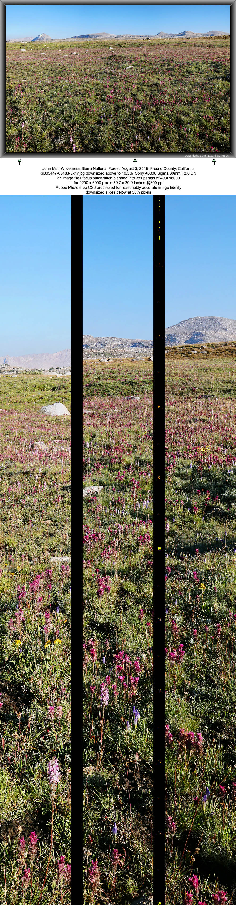
SB05447-05483-3x1v 9200x6000 pixels 3 frame 3 column 1 row 37 image focus stack stitch blend A6000 30mm
enlarged vertical slice view
Next I quickly rambled out a half mile to one of the wildflower meadows we had passed through on Wednesday. With the 7:30am sun still at a low angle, I worked my second subject north-northwest across a level meadow expanse of dewy magenta hued Lemmon's paintbrush, castilleja lemmonii, pink hued little elephants head, pedicularis attollens, and yet unopened blue hued hiker's gentian, gentianopsis simplex. These perennial herbs were amid short bunch grass nicely still green after the recent weeks of monsoon rains. Sticking up in the background mid frame left is Pilot Knob at 12245. Carol Col with peak 12225 is mid frame right. Meadows as this one don't seem to have obvious waters sources. However they are expanses of coarse small rock and rock sands underlain by shallow impervious bedrock atop which waters drain from higher elevation terrain that these plant roots can reach. In small turf pockets one will see areas of water where it seeps out. Notice how a bit higher on this slope the grasses are a bit more yellow? Those sandy well drained soils are a bit deeper, beyond the reach of these species roots as the plant mix changes. Note the lower sky frame left shows a bit of the Ferguson Fire smoke in the distance.
My next subject taken at 7:42am to the southwest is the flower meadow foregrounding Glacier Divide image at page top. It was a quite wonderfully beautiful visual experience standing there that morning. The vibrant green and flower colors were striking. Note the two small meadow pools of water where ground water atop bedrock surfaces. I chose this frame carefully where there was a subtle rolling curve to the terrain while centering peak 12448 that rises above Lower Golden Trout Lake in the background. Scattered yellow hued flowers are alpine goldenrod, solidago multiradiata. Frame mid right, the gone to seed plants with large lily family leaves are alpine shooting star.

SB05532-45 6000x4000 pixels 1 frame 14 image focus stack blend A6000 30mm
enlarged vertical slice view
A bit later at above at 7:52am, I pointed my 30mm lens in a semi back lit direction northeast across the meadows towards Mount Humphreys creating a nice graphic. Such an orientation can be harsh with glistening of bright white highlights. The blue haze is water vapor evaporating after several days of storm put water on the landscape.

SB05602-05649-3x1v 8900x6000 pixels 3 frame 3 column 1 row 48 image focus stack stitch blend A6000 30mm
enlarged vertical slice view
Interested in also working the meadow in mid morning light, I spent the next hour listening to some classic rock music on my MP3 player. Then at 9am repeated working the above SB05447-05483-3x1v subject I had worked 90 minutes earlier. Grass and wildflowers don't individually stand out as strongly, however have warmer more saturated color as the higher altitude more intense sun adds more transmissive color with less shadowing. The blue hiker's gentian are also more prominent as they take a couple hours to open up after closing late afternoon. And caught a backpacker on the trail.

SB05894-09 4000x6000 pixels 1 frame 16 image focus stack blend A6000 30mm
enlarged vertical slice view
An increasing up canyon breeze put an end to work on the above meadow. During day hours the sun warming the vast San Joaquin Valley far to the west causes its air to expand that pushes outward and up the Sierra mountain canyons generating the familiar afternoon winds. That also brings along any mid elevation smoke inversion in the valley. During the Ferguson Fire, radiation cooling during clear nights in the upper Merced River basin causes that heavier cold air to travel down canyons and into the San Joaquin Valley and in the process brings lower canyon elevation smoky air along with it. Also during daytime hours, a cool marine air flow occurs between the Pacific Ocean through north San Francisco Bay and out into the Delta. From there, the marine air pushes both northward towards Sacramento and southward toward Fresno. In that process it brings along any smoky air that had been brought down the Merced River canyon into the valley at night. Then on following warm days that smoky smoggy valley air that was brought south, moves up other river canyons to the south. By that process we were seeing some smoke haze during afternoons that moved up the large San Joaquin River canyons into its South Fork. In the above image shot at 10:20am on a wetter more lush seep meadow I found on higher slopes, one will notice a whitish haze in the atmosphere. The white flowers are an aster or fleabane species.

SB06083-91 4000x6000 pixels 1 frame 9 image focus stack blend A6000 30mm
enlarged vertical slice view
With an increasing smoke haze moving up into the basin, I returned to camp to pass away several mid day hours. It was our first day without afternoon storms and would stay so through the rest of our trip. Later in the afternoon, breezes pushed much of that haze away that motivated a return to meadows I visited during the morning. J who had done well catching several golden trout during the morning in Desolation Lake joined my hike. The above image was shot a bit after 7pm in warming light. Hiker's gentian had closed up and a slight smoke haze still existed. By this time I also discovered the USB-A to USB-C cable to connect between my Bose speaker and a 13000 ma-hr lithium storage battery for recharging was not configured to do such thus the speaker became dead weight the rest of the trip. The storage battery could still charge our MP3 players.

Saturday August 4, 2018 we were up at dawn to pack up, I then got underway for a short hike of about 1.5 miles. A camp site I had base camped at in 2017 was however occupied by two other people. A strong west wind and smoke haze ended the notion of any morning photography and rather early it became the windiest day of our trip. After a long effort stumbling around for a pleasant base camp location we ended up out in the open between Mesa and Tomahawk lakes.
J had brought a second small spinning reel that I was glad to be able to use. I thus went down to Tomahawk lake and using a Kastmaster within an hour had caught two 10.5 inch, an 11 inch, and a 12+ inch eastern brook trout. As an aging adult I have grown to strongly dislike killing fish. However since I do eat meat from supermarkets and restaurants, it is appropriate to at times for we intelligent creatures on this planet we evolved on to occasionally prepare animals for eating just as all our ancestors had to do in order to more fully respect what we are doing. I would bet if people generally actually had to occasionally kill animals they ate, there would be far more vegetarians and far fewer fast food locations. Thus dispatched the above four fish as quickly as I could. Regardless I was aware they in some fish mind way we cannot fathom were suffering after being caught and as I pushed my knife into what I thought was their brain and head, they obviously felt at least for some moments life ending mortal pain. Back at camp, I grabbed J's frying pan and bake fried fish as we have done for decades that includes making a half cup of Minute Rice we mix in after the cooking process is near complete. It was so much food that I was bloated for a napping hour afterward.

Smoke, wind, and our open exposed camp location made this my least enjoyable day of the trip. Three of us went off to the Mesa outlet creek for an hour then split up with J going up to Mesa to fish while M began circling Tomahawk to recover his gloves. Some time later, I followed J and along the west shore took the above photo at 6:12pm with Mount Humphreys in the background while the lake surface was covered by wind driven waves. Day time temperatures were the chilliest of our trip so I had put on my 6 shirt layers of clothing. Note the wind had by late afternoon blown most of the smoke out into Nevada leaving areas of clear blue sky that gave hope for better photography the next day. J and I had a pleasant time circling the lake before returning to our camp site. By this time we also discovered the small speaker J had just received as a birthday present seemed to have developed a software bug and thereafter was also dead weight like my Bose speaker. During the night, without my rain fly above, I awoke to stars all night and by the wee hours the strong wind had also left giving hope for a second decent trip morning of photography.

SB06246-06300-4x1vb 12300x6000 pixels 4 frame 4 column 1 row 55 image focus stack stitch blend A6000 30mm
enlarged vertical slice view
Indeed as the sun rose Sunday August 5, 2018 it looked like a quite fine morning. Some smoke haze was visible far to the west on the horizon while early sunrise skies over Glacier Divide were the bluest yet. After jump starting my day with some hot chocolate theobromine, I was out with my photo gear to a lake shore I had surveyed. A slight cold air sumping breeze was equalizing after sun began hitting the landscape allowing for lake waters with very little ripple. Thus worked the above 4 column panorama that would be the strongest image of the trip.
My next subject was however even stronger though after the trip I discovered I had left my camera during the above work in Focus Mode: Manual Focus instead of Single-Shot AF | Focus Area: Flexible Spot. Whenever I use manual focus that is usually only when auto spot focus is difficult, I have a strongly developed habit to immediately switch back to Auto with a configured dedicated button. A quirk in the camera operation is that when one is in manual focus mode, the flexible spot focus indicator can still be moved around the display screen as though it is changing the focus location, though it is actually doing nothing. Better software would inhibit that and thus alert the user something was not set up correctly. Although there is an icon indicating that mode in the viewfinder, I normally use an A6000 display mode with few icons for subject clarity. Thus disaster occurred over the next 4 important subjects as dozens of focus stacking shots used the identical distant manual focus setting. After buying the camera when it came out in early 2014, I tripped over that setting a few times so changed my process to avoid such in the future. But given mental lapses, I have occasionally continued to be burned.This was quite disappointingly painful to stumble on such a mental failure at such a key point of the trip I had made such a strenuous effort to reach.

An early up canyon breeze had developed that sent me back to camp. With considerable energy to burn I decided to quickly hike the 600 feet up to class 2 Carol Col in order to capture the French Canyon Puppet Lake bench from above. I had done the same during my 2017 trip however the result was mediocre given cloudy storm weather. Thus I rambled on up to Mesa Lake and up to the pass to shoot the above. Since the subject panoramic frame using my 30mm lens was nearly all distant, my manual focus mistake wasn't much a deal. However after mounting my 55 to 210mm zoom telephoto zooms, several of those shots were rather soft.

SB06581-06622-4x1v 12100x6000 pixels 4 frame 4 column 1 row 42 image focus stack stitch blend A6000 30mm
enlarged vertical slice view
After some informational shots of the crux of the Carol Col descent for web use, I climbed down and traversed over to the nearby much less used Star Col ridge line that is supposedly class 2/3 down to Star Lake. From what I could see it appeared just tedious class 2 talus though could certainly be class 3 while the snow field was still present. Somehow I managed to switch back to Single-shot AF mode without realizing I had been in manual focus for an hour and one half. Thus the above image looking north came out nicely sharp as expected. Lots of interesting map locations in this 4 column stitch panorama. At frame left is peak 12225. Just right poking up is 13103' Merriam Pk then 13253' Royce Peak. Further right in the distance is 13741' Mt Gabb then 13713' Bear Creek Spire and 13748' Mt Morgan. Behind Star Lake is half of L Lake that I had base camped at in 2016. To its right is Steelhead Lake with French Lake between the two in the far distance that two of us base camped at years ago. Below Bear Creek Spire is heavily traveled Pine Creek Pass and via the enlarged vertical slice view center slice one can see the small pond at that pass.

After returning to camp at noon, since I thought (: I had nailed all the worthwhile photo subjects of interest about the area and given the unpleasant exposed camp location, I suggested we forgo a second night where we were and instead immediately pack up and hike a mile and one half to a much more pleasant Piute Creek timberline area I had spent a couple nights at in 2017. That was agreed on, thus within an hour we were climbing up and over the ridge then efficiently traversing out towards the creek where we located a fine campsite well above the creek with an excellent view out across the basin I recall looking at in 2017. At this point well practiced at setting up each of our camp areas, by mid afternoon we were fully set up and much enjoying our new surroundings with a nearby fresh seep stream water supply, tall shading trees, a fascinating multi channel stream full of trout, and much lush greenery. I went down to the creek and quite enjoyed a refreshing dip in a sandy chest deep pool, then layed out to dry off on a nearby dark warm boulder. It was also a convenient spot to finally dunk wash my socks. I made a delicious Mountain House Sweet and Sour Pork dinner then spent a couple hours earbud listening to music.

SB06722-06835-6x2v 17900x10200 pixels 12 frame 6 column 2 row 114 image focus stack stitch blend A6000 60mm
enlarged vertical slice view
When light across the basin towards 13993 foot Mount Humphreys was optimal at 6:20pm, I began shooting my largest image of the trip, a 12 frame 6 column 2 row 114 image focus stack stitch blend image that turned out wonderfully per the above. Back home after processing that created a sharp 17900 by 10200 pixel image. In the left slice of the enlarged vertical slice view, one will see a tent and people across the stream. All but a few trees in this view are whitebark pine, pinus albicaulis. Depending on conditions they are able to adapt to a variety of forms from short stunted out on the windy plain or up on the windy slopes at the foot of Mt Humphreys to tall trees in the foreground where water is plentiful and to the lee side slopes of winter storm winds. In winter on windy sites, their top branches readily break off when they stick above snow surfaces thus conforming to terrain shapes. In timberline areas they are often the only trees we backpackers find camp site shade beneath while Clark's nutcrackers dine on their pine cones.
Upon entering a tent each evening, one of the first chores is smashing any mosquitoes and shooing out gnats or flies. On this evening I had unzipped the tent door earlier in order to fill up my water bottle. Well upon entering the tent I heard quite a buzzing sound commotion that turned out to be a big sphinx moth, a favorite night flying nectar loving insect that is on flying par with hummingbirds. I removed my camera body from the tripod and set the mode control to Auto. Then while using my headlamp as a lighting source, managed to capture the desperate insect that was beating its wings against my mesh tent walls. A few moments later it followed my headlamp beam out to freedom.

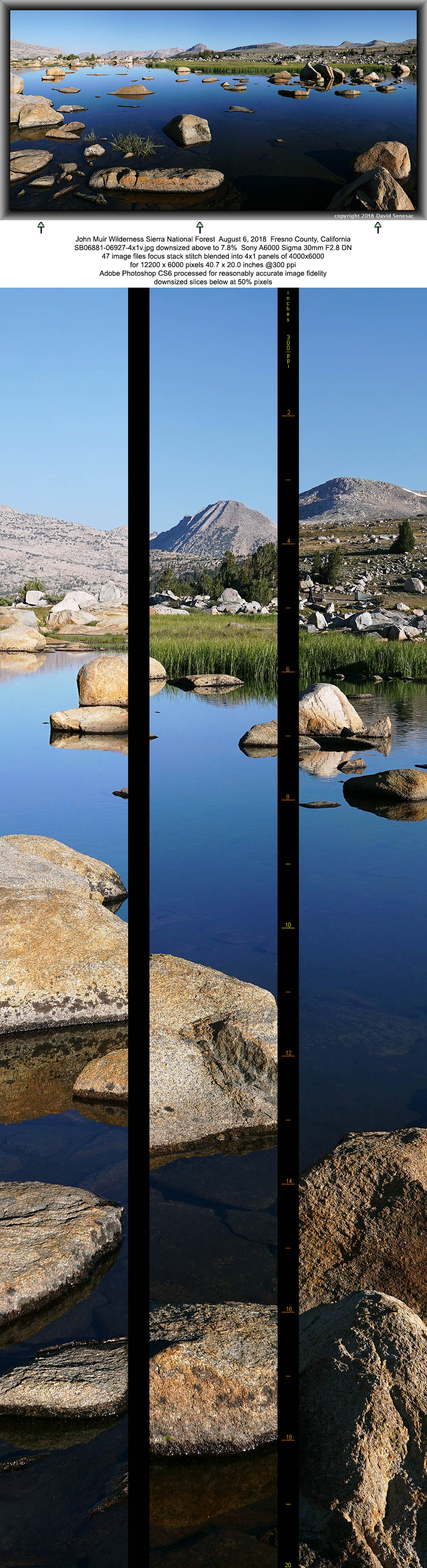
SB06881-06927-4x1v 12200x6000 pixels 4 frame 4 column 1 row 47 image focus stack stitch blend A6000 30mm
enlarged vertical slice view
It was a leisurely rising morning on Monday August 5, 2018. After some hot chocolate I walked down to shallow Grass Island Lake that is visible mid frame left in the SB06722-06835-6x2v two images above. The lake on Piute Creek is unusual with a large grassy patch surrounded by water and many boulders poking through its shallow waters. The water grass is not in fact an island as the tall blades merely rise up through the water. There are abundant pan sized golden trout in the lake and they do swim into the island grasses that provide excellent cover. I looked for a reflection subject as the air was relatively calm with just a residual sumping night flow present. Lakes without much background terrain height above waters present an opportunity to fill a frame with more vertical height foreground elements than usual or if aesthetic clouds are present one may expand the sky frame height. Instead of shooting from the grassy shore well back from my tripod position, I hopped about the many rocks within the lake then considered how pleasing each view looked before choosing this composition at 7:30am. Beyond the lake one views a long expanse of the bouldery gradually inclined basin plain. At frame center is Pilot Knob and to its left The Pinnacles. Below peak 12225 one can see a tent and people in the enlarged vertical slice view right slice.

SB06928-06990-4x1v 12500x6000 pixels 4 frame 4 column 1 row 63 image focus stack stitch blend A6000 30mm
enlarged vertical slice view
For my next subject, I went upstream of the lake and with some gymnastic balance crossed the stream on some wet slippery stream boulders. I then moved around the rocky grassy shore looking for an interesting and aesthetic foreground for peak 12448 on Glacier Divide in the background. That required more rock hopping in order to find an open water spot for the peak reflection. Per image above shot at 7:50am, in foreground areas is a different species of water grass aka sedge versus those that have colonized the "island". And the species at center frame edge bottom is yet another grass species, one of the above water bunch grasses that can tolerate at least limited soaking. Our camp location was in a group of pine well up on the slope frame mid left. Because that slope faces north, it holds late melting snow with considerable numbers of small seeps amid lush grasses and herbs. Thus groups don't need to camp close to the stream in order to have convenient nearby water sources. The majority of backpacker and equestrian groups visiting Humphreys Basin, camp on this north side of Piute Creek, especially downstream about Upper Golden Trout Lake where trees are more common. Note the lower lake has a no camping zone to recover from decades of overuse. Very few groups given lakeitis explore the stream areas between Summit and Upper Golden Trout Lakes. Despite a basin reputation for lack of seclusion, as long as groups in this section site a reasonable distance up on the slope away from the stream, it is an excellent choice for those that actually prefer a wilderness camping experience.

SB07044-07072-3x1v 9500x6000 pixels 3 frame 3 column 1 row 29 image focus stack stitch blend A6000 30mm
enlarged vertical slice view
When I returned to camp J had finished his breakfast so we set off traversing up our slope and into the rocky sparsely treed Wahoo Lakes basin less than a half mile distant. There we found wonderfully blue skies above the peaks and light breezes. Lake 11183 is the largest in the basin. I took this image at 8:45am in one of the lake's bays west-southwestward towards peak 12448. At center frame is the tongue end of a rock glacier out of the canyon beside the peak containing two other much less visited lakes. This lake had an abundant population of stunted pan sized eastern brook trout. A fisherman could easily get strikes from fish on every cast. J was not enthused to bother fishing for its small trout so simply circled the lake where on the far side he enjoyed drinking some extra cold fresh water and filling a Ziploc bag with snow.

SB07073-07100-3x1v 8900x6000 pixels 3 frame 3 column 1 row 38 image focus stack stitch blend A6000 60mm
enlarged vertical slice view
At 9am I found another interesting lake reflection subject above in a shallow bedrock isolated bay with rocks poking above the water surface. In the distance to the northwest is the iconic Pilot Knob. To its left much further away in the Bear Creek basin are Seven Gables and Gemini. When viewing water reflections, the reflection form is not that as viewed from one's eye position but rather that from each point on a water's surface. Accordingly most elements and their reflections are not symmetrical.

SB07126-07165-3x1v 9200x6000 pixels 3 frame 3 column 1 row 40 image focus stack stitch blend A6000 30mm
enlarged vertical slice view
On our way back to camp at 9:50am, I set up the above 3 column image towards the north-northeast that shows the fascinating multi stream areas below Grass Island Lake. I can see part of my light green tent in the enlarged vertical slice view right slice but no one else will. (:

Back at camp we completed packing up our gear then leisurely set out for Piute Pass, about 1.3 miles and 500 feet uphill that we enjoyed crosscountry, reaching the pass about 12:15pm. Down into the North Fork of Bishop Creek canyon we had hiked up 6 days earlier, I stopped to pick up some snow in a Ziplock bag. With smoke haze out in the distance of Owens Valley, I didn't have much reason to camp about the upper basin at 11200 we had earlier discussed so we continued on down to Piute Lake where we sited northeast of the outlet beside the vigorous stream descending from the snowy arctic basin west of Mt Emerson with ultra clean cold water. After setting up camp, each of us rested back in the shade while extracting snow from the Ziploc bag then adding very sugary Koolaid. Mine was grape and I did have quite a bit of that treat. After that M continued to dabble about our camp area especially into his food canister, J went over to the north side of Piute Lake to fish, and I explored down the creek just below the lake. Yep that is me on a most pleasant section of slabs along the creek where I took a nice dip in the stream then laid out on the smooth warm rock. On the other side of the lake, J was catching modest sized brook and rainbow trout as the lake has an abundance of fish.
We all packed up quickly on Tuesday morning August 7, 2018 however I wanted to give the morning a chance to offer a few decent possible morning images if possible so we would linger till about 8:30am. J with his troublesome knee left in order to wait for us down at the Loch Leven Lake outlet thus allowing his knee some recovery before continuing the brutal section below with its hated stone steps. I went over to the lake outlet area trying to wait out taking a couple reflection subjects but the morning breeze both up and down canyon were obviously not going to balance for a lull period so after a brief wait abandoned that notion to complete packing up. Then M and I wobbled down the trail slowly letting our joints ease into the effort, stopping frequently. By 9am we reached J's position then began the step down and grunt effort through the bedrock and metamorphic scree and talus section. Below that we passed trail locations that recalled our climb up a week before, all down down down. Reaching the campground, I lucked out with swapping rides with a couple from Winters that was just hiking out thus neither of us had to walk the half mile to or from the parking lot.

We didn't waste any time escaping the cool high country down into hot low lands then up US395 to Mammoth where we stopped at Vons, some fastfood, before taking a longer lunch and rest in shade break at the Mammoth Visitor Center parking lot. After that it was the long boring drive back to the bro's home and then just me south back to San Jose as I arrived about sunset. Following that was a week of long hours photo processing on my computers and the last couple days hand coding in html this web feature, the main purpose of which is not so much to amuse the current audience but rather much like similar work I've done the last 4 years, provide fresh memory trip details I will be able to far more easily recall versus doing so purely from my time decaying memory, after I start publicly multimedia exhibiting with 8k display screens that at this point given product finally coming onto the consumer market, looks like such could start by early next year.
NEXT: Page 9 20 Lakes Basin Backpack
2018 Trip Chronicles: Contents