
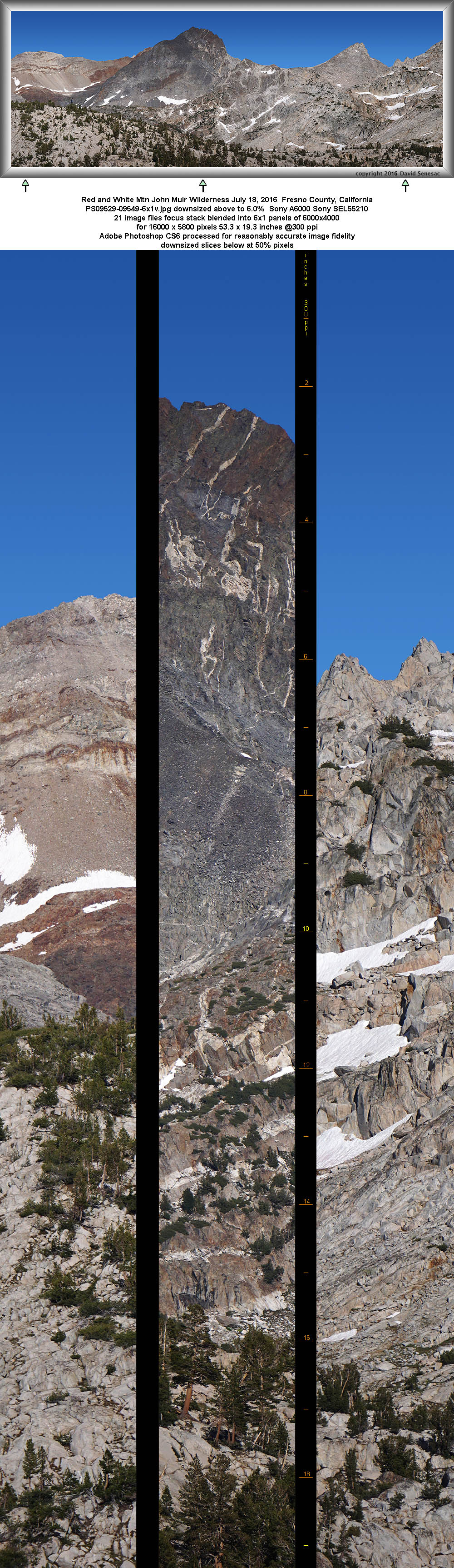
PS09529-09549-6x1v 16000x5800 pixels 6 frame 6 column 1 row 21 image focus stack stitch blend A6000 SEL55210 @144mm
enlarged vertical slice view image text section
NEXT:
Page 12 Silver Divide Backpack 2of2
2016 Trip Chronicles: Contents
Silver Divide backpack 7/15
Silver Divide backpack 7/16
Silver Divide backpack 7/17
Silver Divide backpack 7/18
At the end of April with trailhead quotas filling earlier than ever in the past, I had reserved week long backpacking dates for two trips at the recreation dot gov site. In fact Saturday departures were already filled forcing me to take an extra day, Friday, to start each trip. Dates were dependent for photography purposes on when I expected peak greenery and wildflower conditions in the two areas that were about a week before what would be expected after a normal winter. Although this was the first summer after 4 years of drought with near normal precipitation, it was still somewhat low in the southern Sierra areas. Thus I had carefully checked a list of weather information including snowpack depths at remote CDEC sites. The first 9 day trip into the Silver Divide would begin on Friday July 15 and last till Saturday July 23. Brother Joe would accompany me on that adventure. The second solo 10 day trip would start Thursday evening July 28 and end Saturday August 6.
Silver Divide online topographic map. Use the + window upper left to zoom.
The Sunday before our trip I had pretty much completed fixing, prepping, and packing gear. With about 12 pounds of food, it was looking like my carrying weight would be below 60 pounds or about a dozen less than I typically hefted for week long trips just a few years earlier. Note I am 66 inches 140 pounds so over 40% of my body weight. Another of my 5 brothers that had been planning to do the trip had decided not to go due to medical issues so it would just be 2 of us. On Thursday morning I phoned up the Prather office of Sierra National Forest, setting up a night box pickup of my actual wilderness permit. I left my workplace early in the afternoon, drove home and we were soon heading south on freeways before the main commute traffic. Approaching Fresno, I realized that the lightweight nylon shell top I wear while carrying my backpack was not in my gear. I always put clothing I expect to wear that won't be inside my backpack into a carefully monitored separate stuff bag and sometime during the week had removed it. Thus I decided to buy something at a shopping center as it was a key piece of protection from mosquitoes as they cannot poke their probosci through a tight nylon weave. We found a Sports Authority store, a chain going out of business, and therein found a $58 list woman's running shell for $31. Continuing on we reached Prather, picked up the permit, and a couple hours later had reached a place to toss our sleeping bags out east of Kaiser Pass.

Friday morning July 15, 2016 we were up at sunrise continuing the slow bumpy ride down one of California's most tedious paved single lane mountain roads. The Lake Edison reservoir ferry leaves Vermillion Valley Resort at 9am so we had lots of time. Along the way I was surprised to see considerable smoke on that side of the broad South Fork of the San Joaquin River canyon. As we reached the reservoir, the choking smoke became unpleasantly thick and was all about the resort. Ferry tickets for the 4 plus mile boat ride were $21 each plus another $20 for a week of parking. Our boat left with a near capacity of friendly travelers, most of which were thru PCT backpackers and reached the end of the long reservoir by 9:30am that had managed to fill from near emptiness during this single good winter. Fortunately we had also left the thicker area of smoke but in any case would be smelling it all day during our hiking that irritated my lungs. The fire had started the day before just north of the reservoir in heavy timber near timberline and although the fire itself was not a danger to our trip, it was a huge unknown threatening my photography. Thus would be wondering all day if the strenuous effort I was making up the trail was going to come to naught?
Leaving the high water marks of the reservoir at 7630 feet, we busted through a short stretch of dim forest undergrowth to reach the reservoir spur trail and immediately began adjusting to our sentence of being miserable pack mules. Backpacking carrying much heavier loads than average is not at all pleasant, not at all like simple unencumbered hiking. Even backpacking carrying average loads up mountains usually requires enduring strenuous effort many people would never choose to repeat after a first trip. Our first goal was reaching the big PCT/JMT trail junction where it crosses Mono Creek up 300 feet at 7900 feet at about 1.7 miles. Over the decades I had been on this trail several times so there would be no surprises. Along the way we stopped frequently on every waist high rock and stump as is our style. In swampy seeps, a modest number of mosquitoes followed us, so DEET soon went on our exposed faces, wrists, and hands. Otherwise I was wearing my usual battle gear during mosquito season of Levi 501 jeans, zippered shell, and safari hat with its big neck drape. Worse than the mosquitoes that the DEET took care of were an abundance of aggressive house flies on this horse turd trail that continually kept flying about intent on landing on our sweaty faces. By time we reached the junction, I was ready to take a torso dunk in the big stream. So removed my hat and shell then while laying on a convenient streamside flat boulder leaned over into and under the water face down while splashing water with my hands over my back. And was it nicely chilly haha.
Continuing on another 3/4 mile we crossed the smaller North Fork of Mono Creek at 2.4 miles on a partially submerged rock hop then began the crux of this day's pain, a 700 foot uphill over a mile of trail that routed on sunny warm south facing manzanita brush slopes. That section of horse trail contains many knee high block step ups that I dislike with a passion. By time we reached 8700 feet I was quite exhausted so we wandered off trail over to a granite slab area of the nearby stream where I dispensed with clothing and submerged into a cool whitewater pool. The combination of not yet being acclimated to the thinner air at altitude and lung irritating smoky air left me weaker than expected carrying my huge load. An hour later after some snacks and rest we continued up the trail, entering the Pothole Meadow section that had increasing numbers of mosquitoes that required occasional re-applications of DEET that would flow off with sweat.

Later afternoon at 8950 feet 4.5 miles along, we left the big thru trail and continued on the narrow Mott Lake spur up the north fork that rises 500 feet over 3/4 mile about a dense shady fir and lodgepole forest. That effort expended about all that was left in this body as I struggled to go from rock stop to rock stop. Eventually with ever more mosquitoes flying about, we reached my target zone at 9500 feet that ended our day with 2100 feet uphill vertical and 5.6 miles. We pitched our tents, I got my dinner set to go next to my tent door, put on my rain gear nekid underneath to stop mosquitoes, wandered over to a waist deep pool in the nearby stream, took off the rain clothes in a flash and submerged. While wet, mosquitoes never bite so I quickly walked back up to my tent and got safely inside to dry off. After consuming my freeze dried chicken rice dinner, lying atop my NeoAir, closed my eyes, falling asleep quickly well before sunset.
That night I awoke about midnight, still smelling smoke, and ominously could not see any stars. But then about dawn skies cleared somewhat, stars came out, and the smell of smoke had greatly decreased. With dawn rising Saturday morning July 16, 2016 I got out of my tent and went over to Joe to discuss new plans. Instead of continuing on up the trail to Mott Lake we would stay put during early morning until I could make sense out of what was going on with the fire. If it looked dismal, we would hike out, drive to Prather, and get a permit for Red Mountain Basin that was far enough south it would be out of the smoky zone. Well I hiked up the trail to where I could see down canyon further west and noted no smoke plumes. The stars had been blocked by high clouds, not smoke, and blue sky was increasing. I returned to our camp zone, we took a few images near camp that had an abundance of wildflowers and gambled on continuing our trip but not quite as planned. Given the weaker strength I'd felt Friday and our delayed start, instead of going over Rohn Pass this day, we would only go as far as the north shore of Bighorn Lake that we had much liked on a previous 2008 trip. Our first goal was Mott Lake 500 feet higher.

And that we did in much better form than our hiking Friday. The cool clean air without the lung irritating smoke made a lot of difference. At beautiful Mott Lake at 10075 feet, we were surprised to see a larger population of trout about the waters than we had seen in 2008. On the return leg we were to find they were not the rainbows we had previously caught but rather golden trout so there had apparently been an aerial drop of fry a few years before. Since the lake was initially calm and reflecting, I spent a half hour taking a few images that ended up being overexposed. We continued past the lake into the cross country trailess zone of the headwaters. Once reaching 10300 feet, the U-shaped glacial canyon opens up and levels into a half mile long valley with fewer trees due to winter snow avalanches. Considerable areas between granite bedrock offered wildflower covered bright green turfy meadows while numbers of streamlets came down from still melting snow patches. Reaching the end of the little valley was a moderately steep climb of 500 feet to our destination, Bighorn Lake at 10875 feet.
After that strenuous effort, we relaxed for an hour midday at the lake's south shore outlet before continuing on to the far side of the lake. Reaching that end required crossing one tedious snow field and a few up and downs along the lake edge. Unlike the meadows we had passed through below, there were not many mosquitoes about this more exposed to breezes headwaters lake. We had watched some smoky haze move up the canyon but it was far less than on Friday. Thus it was looking like the fire had quieted down so my decision to continue with the trip was looking positive.

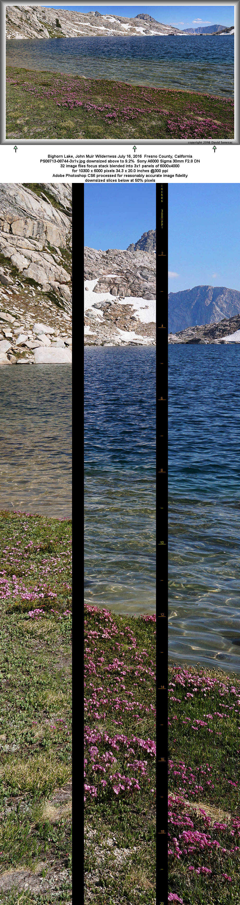
PS08713-08744-3x1v 10300x6000 pixels 3 frame 3 column 1 row 32 image focus stack stitch blend A6000 30mm
enlarged vertical slice view
By mid afternoon we arrived, tented, set up our gear, and then took a refreshing dip in the chilly crystal clear lake waters. Many larger timberline lakes have small sections of sandy shores where larger wind driven waves wash against shorelines removing usual algae on lake bottoms leaving bright lake bottoms near shore. Along the turf and sand edge were dense bands of beautiful pink hued alpine laurel, Kalmia polifolia. These flowers are the earliest alpine meadow wildflowers that signaled I had nailed the peak bloom at elevations I was most interested in working. Lying atop a convenient warm granite slab beside the shore, I noticed trout moving about in the clear near shore waters so yelled up to brother Joe who is the more serious fisherman. On 3 previous visits we had noticed only a few large golden trout but apparently a few years before there had been an aerial drop of rainbow trout fry.

I rigged up my fishing gear putting on a small Kastmaster then returned to our sandy beach. In quick order of 3 casts I caught 13 inch and 11.5 inch rainbows so was soon back up at my camp making a fish and rice dinner. As is our trout preparation style, after fish have heated up in an aluminum foil covered frying pan with just a thin coating of oil, we use a pair of small long nose pliers and fork to grab backbones, peel away flesh, remove bones, fins, and most of the skin. Note the little pile of bones in the picture. Before starting the fish I had cooked a half cup of Minute rice that was set aside. After the trout minus bones are well done we mix in rice and cook a couple more minutes. Cooking completed, with a bit of salt added, it was utterly delicious and just the kind of protein my body was craving.

Joe on the other hand would be away fishing for another hour. Later as he began frying his smaller fish, early shadows from sun blocking Mt. Izaak Walton, would soon dim our zone so I set out with camera gear to see what the area offered. I was a bit late for a few modest subjects I came across and was soon back at camp. Well before sunset I was once again in my tent ready for another long night of sleep. Although the lake has a potential for excellent dusk pink earth shadow views southward, there was still hazy smoke in the air.

As early risers that love the early mornings we were awake at dawn on Sunday morning July 17, 2016, and packed up promptly that usually takes us only about a half hour. And no, on days we are on a route at sunrise, we do not bother with any breakfast and in fact I have lived for years not usually eating any breakfast on work days as eating too often daily tends to age at a greater rate one's internal body that over decades may have affects. Our ancestors did not eat 3 meals a day as food preparation was considerable work. With turfy meadow grasses showing frost, a clear sunny sky above, a slight sumping breeze across Bighorn waters, we were on our way to the top of Rohn Pass at 11250 feet one step at a time as the first rays of sun began creeping down slopes of Mt. Izaak Walton to our west. After a long night of refreshing sleep, stopping just a few times briefly, we climbed the moderately steep 375 feet from camp that required some visual route finding near the top. Thus our lungs ability to capture oxygen molecules into our blood streams was finally catching up to the low oxygen at these high altitudes that usually takes me a couple days. At the pass we noted a really nice spot to camp on gruss sand between bedrock in the shade of a whitebark pine.

On the north side was as expected a maze of bedrock and steep frozen suncupped snowfields with our task to visually figure out a way down lest we hike along the ridge 1/4 mile east up 200 feet to Shout of Relief Pass that is easier at the top. In a few weeks, those crossing mid August early morning would have little issue with snow but not so now mid July. It is 520 feet down to the bottom at the no name pond I call South Pond at 10730. The top 100 feet is the issue. It is challenges like this that one tends to remember for years adding a sense of real adventure to these trips. Directly below that the gradient eases up briefly at a loose rock band before plunging down into a larger snowfield 200 feet steeply again. To escape the latter, one must traverse to hikers right where it eases up in order to attain the wide bench below Shout of Relief Pass at 11100 feet. From there it is all loose rock and turf down to South Pond. We could see monkey climbing down to our right of the snowfield looked class 2, but there was a snow gap of about 10 feet we would need to cross. Below that we would drop some at the loose rock band and then gingerly traverse right where the icy snowfield was less steep enough that even if we fell, would not slide down further to where it plunges down.
So with Joe leading, down we went, stopping at the gap to consider options. A fall would result in a fast slide down at least 20 feet into rocks that could be injurious. A 6 foot long boulder with melt out gaps at its edge offered something to stick one's legs down into to stabilize the start. Joe grabbed a rock and began pounding steps in the hard cold snow. I mentioned, too bad he had not stuck his gloves deep down inside his pack. After a few minutes he used 3 slightly sloping steps to get close enough to the other side that he was able to dynamically step across onto a sloping semi level spot before slipping. I removed my photo daypack that is bunji'd to the top/back of my pack and tossed that across from the boulder which Joe caught as it slid down below. Using my tripod for some stability repeated his steps without issue. One down another to go.
Joe made it down to the wider section of moderate sized frozen suncups we needed to traverse and after reattaching my daypack followed. The beginning of the traverse was a bit steeper so I got down to a sideways sitting position then slid suncup to suncup with the side of my pack sliding against the snow providing grating resistance. Where it eased up, I got up on my feet and used the tripod again to go from one level place in the slippery suncup maze to the next. We left snow and bedrock and rambled east on the soggy turfy bench to where we were below Shout of Relief that was class 1 through turf, sand, and loose rocks to the bottom at The Plateau of Ponds. From there my next objective was a turf hummock pond I've photographed over the last 2 decades. In between was a familiar convoluted up and down terrain of 3/4 mile with small snow patches and several ponds.

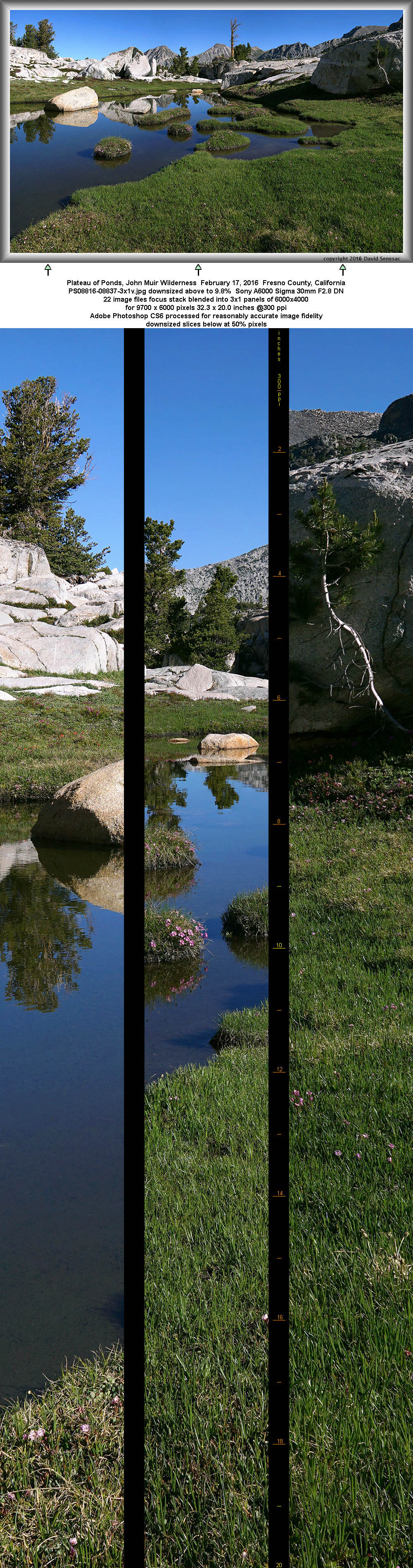
PS08816-08837-3x1v 9700x6000 pixels 3 frame 3 column 1 row 22 image focus stack stitch blend A6000 30mm
enlarged vertical slice view
We reached the pond at 8:15am when the landscape lighting was optimal. The conditions were absolutely perfect with the turf at its peak summer green, alpine laurel adorning the hummocks, and red mountain heather, white heather, and Peirson's paintbrush scattered against granite outcrops. I would take two sets of images, one towards the north and the other west using my Sigma 30mm F2.8 DN lens. For the first image above I chose to back away from the pond edge in order to foreground the wonderful turf these meadows present.
The short height luxuriant lawns are actually a combination of several species of plants with a dense matrix of roots and rhizomes below ground that holds the alpine soil together despite its harsh environment. After snows melt it takes a few weeks for the brown dormant grass of winter to change back to green with new growth rising from roots below. The period these alpine grasses are green lasts only a few short weeks even though water may still be abundant into late summer. After the green leaves have provided a period of manufactured nutrients to roots below, seed spikelets appear and their above ground life cycle completes while down in roots a biochemical cycle continues until freezing fall temperatures put them back into dormancy. Thus a visitor to this same location mid August would likely just see mostly drab brown thus a reason photographers ought to learn how to put up with a few more mosquitoes versus the bug free conditions of late summer. The alpine laurel begin blooming while the turf is still between brown and green and quickly begins to disappear while turf greenery has just reached early greens. In fact when we were looking at this scene, I commented to Joe since we would be base camping in this zone for most of the following week, that although I expected to have time later to return to the scene, in just a few days the pretty pink flowers were likely to mostly drop off so I needed to stop and nail this landscape while it was perfect. And indeed half of those flowers did drop in just a few days. The other two heath family species, red mountain heather and white heather are more synchronized to the turf greening, last longer, and are more widespread across other types of alpine landscapes favoring the edges of boulders.

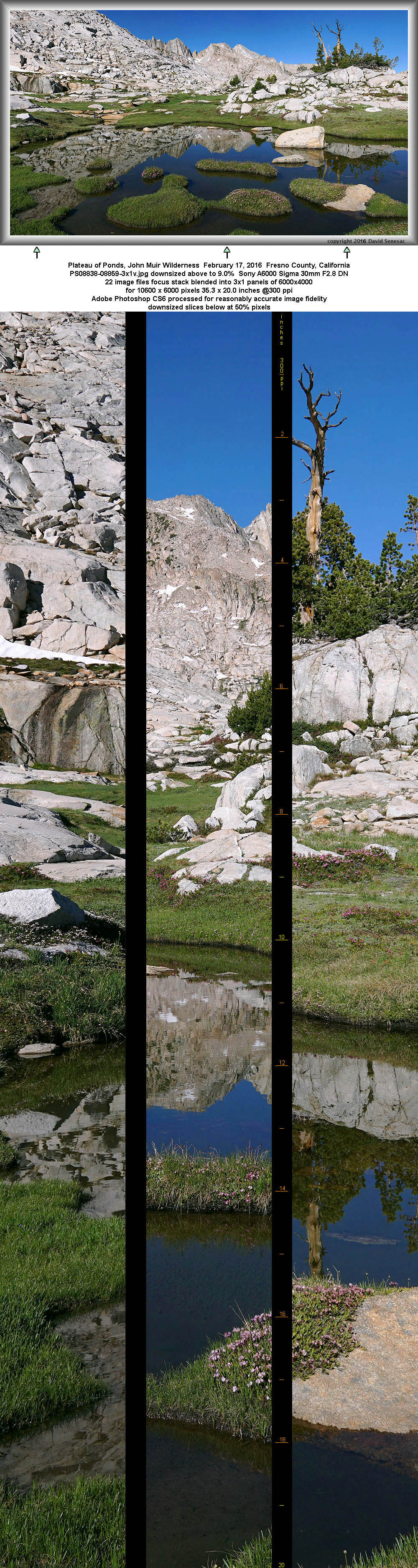
PS08838-08859-3x1v 10600x6000 pixels 3 frame 3 column 1 row 22 image focus stack stitch blend A6000 30mm
enlarged vertical slice view
This second image looking west to what I call Silver Spur, I consider the finest landscape on The Plateau of Ponds. My capture above is better than what I produced with my 4x5 years earlier because stitch blending allows better control of frame boundaries and of course per above the conditions during the above shot were optimal. These natural turf hummocks occur in shallow alpine ponds throughout the range. They tend to have smooth rounded outlines often in whimsical cartoonish shapes that can present some of the best foregrounds a landscape photographer will ever find in our mountains.

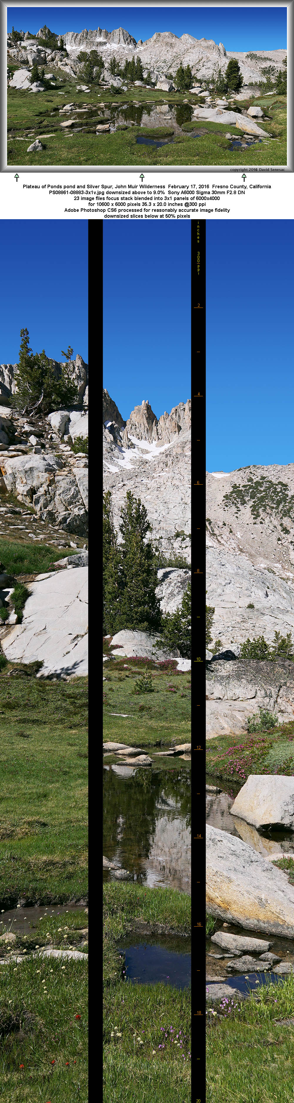
PS08861-08883-3x1v 10600x6000 pixels 3 frame 3 column 1 row 23 image focus stack stitch blend A6000 30mm
enlarged vertical slice view
Back on our route we continued towards our first base camp one of two we would camp at in this zone for two nights each. I won't identify where they are except to say they were positioned so we could accomplish considerable day hiking to various areas and lakes. The Plateau of Ponds is camped on infrequently because most visitors to the zone choose Tully Lake that is on a trail and has good fishing. Of course and amusing to this person, the itinerary of 95% of backpacking groups in all areas of the Sierra Nevada tends to be a lake to lake fest as though such are the only destinations of interest. A few groups each summer camp at Izaak Walton Lake, Mace, Hortense Lake, Lee, or Red and White, all of which have trout but require some awkward off trail route finding to reach. The only waters on Plateau of Ponds with trout and where groups camp at all is Little Tully Lake just west of Tully Lake. I found that small granite bound lake not particular aesthetic because the bright igneous rock tends to be contrasty once the sun is up in altitude. Note the only body water with a topo name is shallow Cotton Lake with pleasant turfy margins but is barren of fish. The rest of the plateau other than along where groups descend from Rohn and Shout of Relief to reach Tully is rather pristene with many local nooks and crannies one can easily camp in hidden seclusion without expecting any groups to saunter by. With just modest numbers of scattered whitebark pines, afternoon shade for tenting is more likely to be found along bedrock walls that face to the east. I have placed names on many of the ponds. I've named the arete rib just south of Cotton Lake, The Bowling Pin, due to its shape from points north.

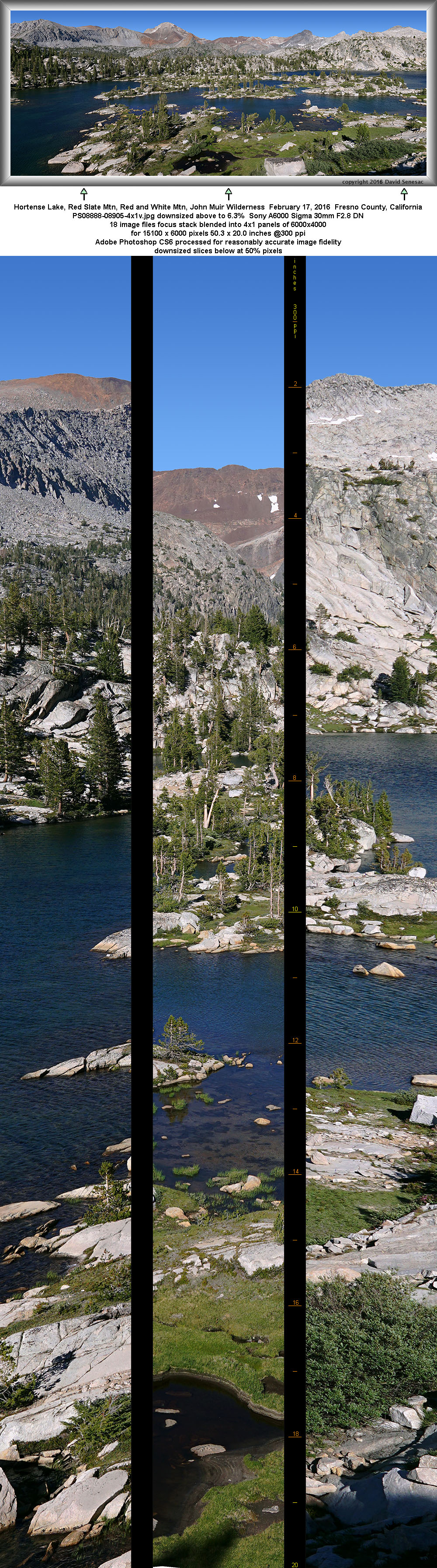
PS08888-08905-4x1v 15100x6000 pixels 4 frame 4 column 1 row 18 image focus stack stitch blend A6000 30mm
enlarged vertical slice view
After finding a camp spot behind tall whitebark pines, we made camp, lunch, and napped now that we had finally completed the strenuous portion of our adventure and could relax over the following days. Sunday afternoon we went off on a day hike to Hortense Lake but my photography was limited by gusty winds as the dry end of a trough moving through the Northwest brushed across the Sierra generating strong winds though winds also cleared out the air across the range. I climbed up above the west shore of the lake to capture the above panorama. Red Slate Mtn is skyline mid left, Red and White Mtn mid right, and Mt. Izaak Walton at frame right.

Blending frames with wind formed wavy water is not a simple process and may not end up successful. Much depends on what Photoshop produces that is not within one's control. If the result is unnatural, one can use layer masks and pixel massaging however that can be tedious. Generally the larger the intended result, the more difficult it is to end up with natural looking transitions between blended frames. Thus creating a small downsized for web image that looks natural is easy while creating a professional looking large fine art print that customers might spend at least several hundred dollars on can be increasingly difficult or impossible. For the above image, by moving well away from the lake, the algorithm was able to automatically naturally blend adjacent column areas with water without my needing to do anything more. On the other hand, using my 4x5 view camera would have allowed creating images from anywhere along shores with wavy waters as there is no blending involved and only some blur due to slow shutter speeds using highest quality film.
At sunset the clear air provided some strong orange phase light on the crest peaks but then suddenly it all went dim as the sun apparently descended into the expected brown haze unseen far to the west above the Central Valley. As is often the case with dry summer fronts centered in the northwest brushing California, air over the Sierra may be replaced while dirty smoggy air down in the valleys remains stale down below those over running winds.
All night when I woke up, there were sounds of wind in trees. Thus as sunrise rose on Monday July 18, 2016, I was somewhat unenthusiastic about getting up out of my tent to see what the morning offered. The most likely time of day one will encounter calm in the High Sierra is early to mid mornings however that varies greatly depend on specific locations. Areas at passes, ridge lines, or down at the bottom of stream canyons below rocky headwaters basins where night sumping breezes occur are least likely to be calm while isolated benches on canyon walls and in the middle of broad plains most likely. However all these places can also be windy or calm depending on larger atmospheric patterns. In my case Monday was a latter situation due to the noted dry front still pushing through. Not only did that limit my work around lakes but also made any vegetation and flower close-ups futile as focus stacking requires static subjects without movement. However late in the day telephotos would not be affected. In the morning I explored our zone looking for subjects I might work when breezes died down.
Later in the day hiked out to a good view point for the overall zone and when late afternoon light was best about 5:30pm captured the image at page top, Red and White Mountain, Silver Divide, a wide 6 frame panorama with Red and White Mtn mid frame left. The unnamed triangular peak to the right plus two smaller peaklets just right I call White Crags and is the impressive peak in the background above Mott Lake. The sub peak below and to the right of Red and White with quartz veins against darker rock, I call Veins Peak. Veins Peak presents a particularly nice landscape late afternoon and sunset from the pond at 10750 to its northwest that also has its colorful talus about its waters.

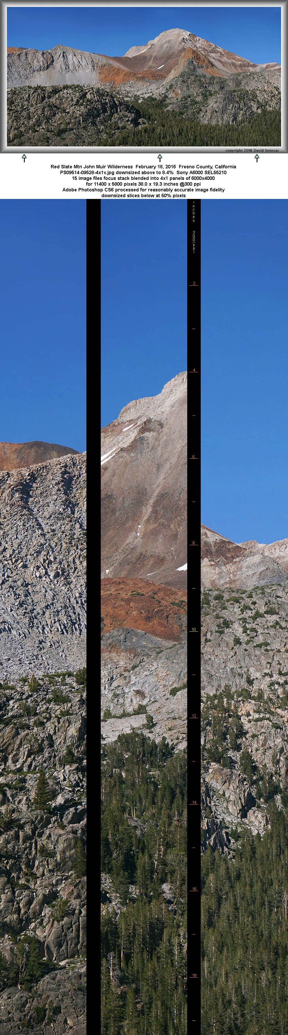
PS09514-09528-4x1v 11400x5800 pixels 4 frame 4 column 1 row 15 image focus stack stitch blend A6000 SEL55210 @73mm
enlarged vertical slice view
Another telephoto lens target was the colorful Paleozoic geology of Red Slate Mountain and ridge line of the Sierra Crest in the image above. The left side of the peak are its very rusty hued northwest slopes that end up in a talus lake not in view from this position. The lake has no outlet because water seeps through the very porous talus then springs out just above larger Lee Lake that is also not visible from this position.

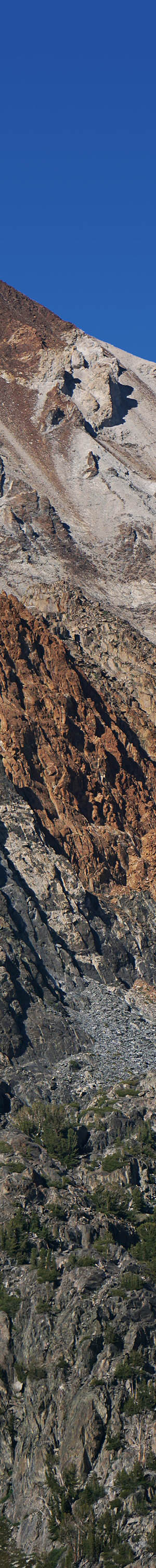
PS09550-52 4000x6000 pixels 1 frame 3 image focus stack blend A6000 SEL55210 @142mm
enlarged vertical slice view
Just above is a more magnified telephoto close-up of the geologically fascinating Paleozoic rock west face of Red Slate Mtn and the peaklet on the rib to its west I call Rusty Knob. The knob is just south of Lee Lake. There is a somewhat tricky to find class 2 route from the outlet area of Lee Lake that climbs 300 feet up to the west end of the knob from which one can then access a pond and two domes I call North and South Bald Domes from which it is a gentle class 1 walk down to Triassic Meadow and the trail.

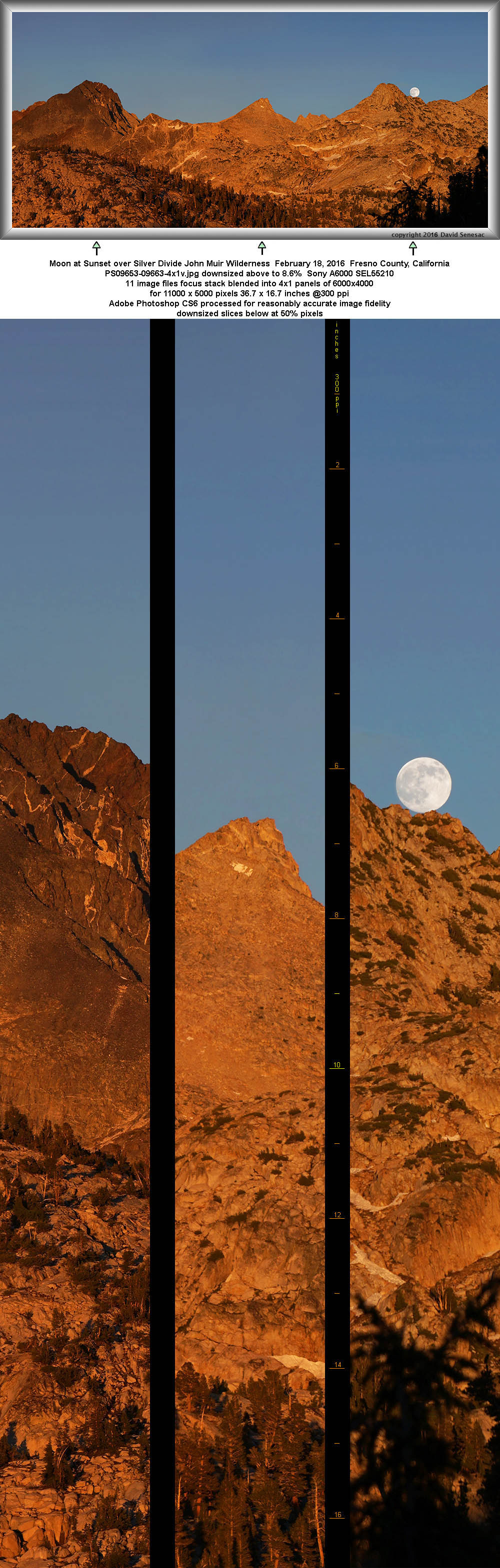
PS09653-09663-4x1v 11000x5000 pixels 4 frame 4 column 1 row 11 image focus stack blend A6000 SEL55210 @103mm
enlarged vertical slice view
At sunset given experience of where the Moon rose Sunday and information I had copied before the trip, I was more prepared when the now full moon did so this Monday. Again we had clear air during the orange phase so at 8:09pm PDT captured a set of images just as the moon was cresting the Silver Divide. I underexposed by 5 stops the Moon on one shot and then layer mask blended it onto shots exposed for the landscape.

A bit later at 8:32pm PDT as the Earth shadow rose in the sky repeated the above for a single frame. That was the only time during the trip the Earth Shadow had decent pink and purple color as the hazy smoky valley skies both east and west of the Sierra otherwise caused dim murky results.
NEXT:
Page 12 Silver Divide Backpack 2of2
2016 Trip Chronicles: Contents