
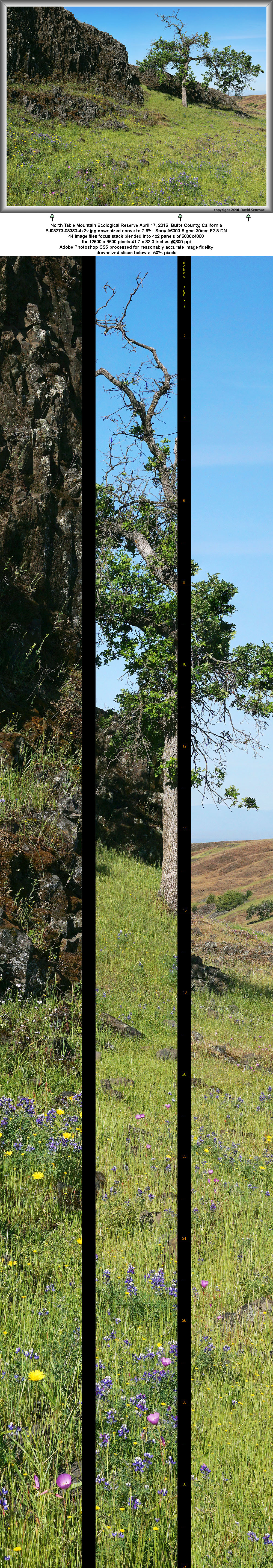
PJ08273-08330-4x2v 12500x9600 pixels 8 frame 4 column 2 row 58 image focus stack stitch blend A6000 60mm
enlarged vertical slice view image text section
NEXT:
Page 9 Tuolumne Rim/Glen Alpine Backpack
2016 Trip Chronicles: Contents
North Table Mountain Ecological Reserve 4/17
Ring Mountain 5/1
Russian Ridge 5/8
San Mateo Coast 5/22
Tuolumne Rim 5/28
After my April 1 trip to North Table Mountain Ecological Reserve, I hoped to return the following weekend but foul weather and wind forecasts went against that notion so instead stayed home processing a considerable backlog of imaging. Wind forecasts approaching the second weekend were marginal for Sunday with Saturday likely unworkable. I also had doubts about species conditions because 2 weeks would mean most species I had seen would be withered and gone to seed. However was curious about what the reserve looked like with late blooming species. At short notice decided to make the trip, starting by taking in a Saturday meetup.com event by East Bay CNPS at Jepson Prairie up in Solano County.
That Saturday morning April 16 was on the road early before sunrise reaching the reserve parking lot at 9am where about a dozen people were leaving on a docent tour with an early group. As forecast it was much too windy for serious photography. Although the following docent led tour I attended was interesting especially some of the pond invertebrates captured, the vernal pool landscapes had only modest aesthetic appeal and the same wildflower species blooming at that time were common in some other places I visit. After a couple hours I drove off to Vacaville and visited a brother where I enjoyed a nice grilled salmon lunch while watching a Warriors versus Rockets NBA playoff game. Later in the afternoon continued on north to Butte County exploring peripheral areas in that region I had noted on maps.

PJ08546-08569-3x1v 10000x6000 pixels 3 frame 3 column 1 row 24 image focus stack stitch blend A6000 30mm
enlarged vertical slice view
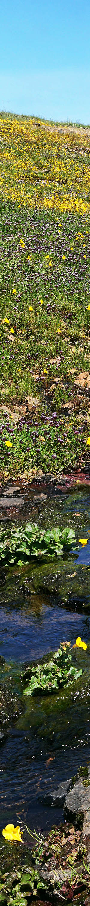
Sunday morning April 17, 2016 set out early across North Table Mountain Ecological Reserve where conditions had indeed advanced so much that areas I'd visited a couple weeks earlier looked very different. Although there were still many flowers of now different species in some areas, their visual impacts were much less aesthetic. Additionally the wonderful lush green look was gone replaced with a greenish yellow gone to seed phase. At page top, the pleasant though modest image PJ08273-08330-4x2v is an example of these landscapes. Indeed many flowers but much less dense color overall. Early afternoon increasing breezes was a signal to leave and on the way out took this second image above not far from the parking lot. By that time, there were large numbers of visitors about with several dozen vehicles in the lot and along Cherokee Road.

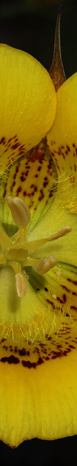
PJ08588-96 3600x3600 pixels 1 frame 9 image focus stack blend A6000 60mm extension tube diffuser
enlarged vertical slice view
Along Cherokee Road where it drops off the plateau, stopped roadside where large showy gold nuggets, Calochortus luteus, were scattered across the oak savanna slope grasslands. There are several large mariposa lily species that I am keen to photograph using the new focus stack blending technique because for the first time it is now possible to capture these very 3-dimensional cup-shaped flowers with adequate depth of field for a highly detailed image fully in focus. Unfortunately doing so was difficult as I used both my collapsible disks to block breezes as much as possible. In the end had to be content with a somewhat smaller set of captures. Note calochortus species close up tightly at night before opening later morning so a photographer cannot rely on working these flowers early morning when breezes are more often calm. Beyond Oroville stopped an hour along Larkin Road at the Thermolito Afterbay reservoir park where I found considerable numbers of species densely within tall grasses I might work during calmer conditions on a future spring visit. Overall an unproductive weekend but I rolled the dice and have learned sometimes snake-eyes comes up.

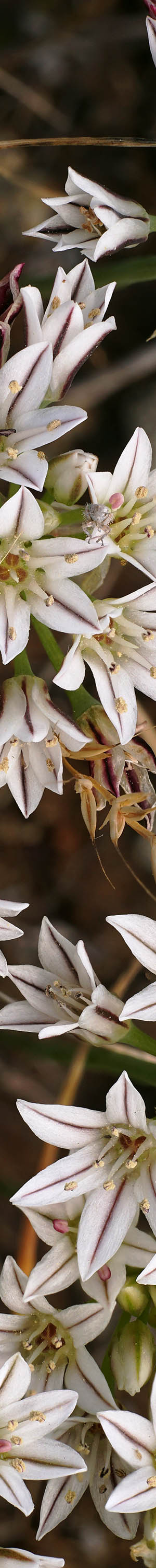
PK08660-68 4000x6000 pixels 1 frame 9 image focus stack blend A6000 60mm extension tube diffuser
enlarged vertical slice view
Two weeks later on Saturday May 1, 2016, drove up north to Marin County where I did a quick road tour out to the coast but found conditions somewhat dry and wildflower numbers mediocre versus good years. So I quickly changed to plan B, a visit to Ring Mountain Open Space Preserve on the hilly ridge line of Tiburon peninsula to look for Tiburon mariposa lily that according to my extensive logs from past years should have been blooming, another large very 3-dimensional mariposa on my list to capture with focus stacking. Previous captures with my G10 are regardless rather nice. But no, no lilies were blooming except for a single mediocre specimen I ventured across? Oh well the view of San Francisco Bay for miles in several directions was excellent. The hilly slope looked drier than expected with some other species also absent. What was abundant was pitted onion, Allium lacunosum, in the image above. California has a long list of onion allium species almost all of which have the distinctive onion odor if one puts a nose down at the often short height plants.

PL08791-02 3200x4100 pixels 1 frame 12 image focus stack blend A6000 60mm extension tube
enlarged vertical slice view
The following weekend Saturday morning May 8, drove up to nearby very popular Russian Ridge Open Space Preserve along the crest of the Santa Cruz Mountains. The day was nicely overcast with diffuse light from cloud banks pushing up against the coast but that also brought breezes flowing over the ridgeline like water spilling over a dam that was unproductive to work with. Nice numbers of wildflowers and species were about the reserve that was now at spring peak. It was much better than the previous 4 droughty years but much less impressive than in 2005. Regardless had a nice 4 mile hike workout. Along the way captured these pretty red maids, Calandrinia ciliata, above with purple vetch, Vicia villosa, an alien European cattle forage species widespread about Northern California grasslands. As a young kid, vetch often grew in fields of our Orangevale neighborhood where we would create tunnels through its dense tangled thigh high growth. In the above I was surprised how aesthetic its flowers look in close-up detail.

PM08895-08909-1x2h 5900x6900 pixels 2 frame 1 column 2 row 15 image focus stack stitch blend A6000 60mm
enlarged vertical slice view
Weekend weather and wind once again kept me close to home for the sixth straight weekend. Saturday morning May 22, 2016, drove the 45 miles from where I live in Santa Clara Valley over the Santa Cruz Mountains to the San Mateo coast where with tides cooperating, looked over some shore stone areas for close-ups. The above is an example of seashore stones that have dried off while at other times a subject may be freshly wet from waves washing up on the shore. The work tends to be a game of not getting caught by waves washing up on shores so my ears are tuned to the patterns of breaking waves while eyes focus on pebbles and stones below. Of course salt water splashing on expensive cameras full of micro electronics is very dangerous as water has a way of quickly entering any cracks in cases or lenses so this is more than just getting one's clothing wet. The conductive salt water will short electronics out when wet and after drying can cause all manner of intermittents that varies with humidity. More of my shore stone subject choices tend to be dry that better benefit from the higher detail despite losing a measure of color saturation. For years might be the only Central Coast photographer working such subjects.
The Memorial Day holiday weekend found this person on a road trip to a familiar forest wildflower region I've enjoyed several times in the past. A serious problem for anyone with Sierra Nevada notions on the holiday is avoiding crowds. Still melting snows at higher elevations concentrate visitors at lower elevations. But I would have no such issue that weekend. Well at least until escaping the choke traffic points leading east out of the SF Bay Area. After escaping from my workplace mid afternoon, to avoid traffic once over the Sunol Grade, I went through Pleasanton via Stanley Blvd to Concannon Blvd through Livermore, to Tesla Road up and over the hills to Corral Canyon Road out to I580, then across SR132 through Modesto up to Colterville, and finally east on J132 to highway SR120 at Buck Meadows. By dusk on Friday May 27 after driving nearly 190 miles, had reached a pleasant near roadside spot to overnight disperse camp inside my Forester. Reflecting how out of the way my destination was even on that heavily traveled holiday getaway day, only a dozen or so vehicles passed by during the rest of the night. The region is what I refer to as the Tuolumne Rim.
My car was parked at the canyon rim along narrow, paved Mather Road at elevation 4300 feet about 4/10 a mile away from and 1500 feet steeply above the Tuolumne River that I listened to whenever wakened during the pleasant night. At several places one has roadside views north into the big canyon. One can legally disperse camp anywhere about national forest or Bureau of Land Management public lands unless there is specific policy against doing so. Here in California the vast majority of those lands are open to dispersed camping though individuals need to do their homework finding out where those lands are and their policies. The rim areas west of Camp Mather are particularly exceptional at this time of year for doing so because it is most green with wildflowers peaking, it is out of road travel paths, it is well below still melting snowy elevations yet above lower elevation heat, and there are numbers of dirt spur roads coming off of the little paved road where one can find a bit of privacy versus being right on the road. Arriving in the evening of a warm day about lower Northern California urban areas, it was a pleasant 67F degrees and by dawn in the lower 50s thus ideal for sleeping. Negatively, these areas were within burn areas of the horrible Rim Fire in Stanislaus National Forest or Yosemite National Park, so I did not expect to work any larger landscapes during my 2-day trip.

PN08962-08974-1x2h 5700x6600 pixels 2 frame 1 column 2 row 13 image focus stack stitch blend A6000 60mm
enlarged vertical slice view
Saturday morning May 28, 2016, rose at dawn and was soon rolling slowly along the quiet road looking for wildflower subjects and they were all about. On sunny days, early morning is often calmest and before sun is high enough to shine on subjects one can use the unsaturated early blue skylight as a diffuse lighting source. I climbed up from the road where I noticed a dense patch of seep-spring monkeyflower, Mimulus guttatus, above the road, a bright yellow subject that would greatly benefit from diffuse skylight versus harsh sunlight. The flowers grew atop complex bio-mat communities of primarily moss that were atop glacially smoothed sloping granite bedrock where water on slopes above drained down along the impervious bedrock boundary. Between the moss mats were bare rock areas blackish green with slippery slimy algae. Here and there contrasting yellow petals had fallen onto edges of the dark bare rock. The heavily dewy monkeyflower had obviously been blooming for several weeks because there were many stems already gone to seed. See the dewy spider webs just in front of the dark slab? The water source would soon shut off and its greenery would quickly dry out, brown up, and go dormant. Wildflower work on this trip used my Sony A6000 atop the super gymnastic Benbo Trekker tripod instead of my standard landscape Induro tripod setup that uses a manual panoramic head with the camera oriented vertically. With the Trekker most of my stitch images below are just 2 shot stitches with horizontal camera orientations, single column 2 row.

PN08983-94 4200x3800 pixels 1 frame 12 image focus stack blend A6000 60mm extension tube diffuser
enlarged vertical slice view
A short ways further pulled out again on the roadside where an abundance of the beautiful grand collomia, Collomia grandiflora, grew amid mountain misery. The collomia have an extremely rare plant color, light orange. Its 5 petals are complemented nicely with 5 light grayish blue anthers while the 3-cleft trifid stigma remains orange. A member of the phlox family that blooms at these elevations beyond the peak of most other species, I hunted for a subject with a group of nicely shaped petals around a symmetrical head. The sun was now shining on the plant so had to use my 32 inch diffuser on one side and my 32 inch reflector as a shield against a pesky breeze on the other. Times I could use an extra pair of hands.

PN09038-49 6000x4000 pixels 1 frame 12 image focus stack blend A6000 60mm extension tube diffuser
enlarged vertical slice view
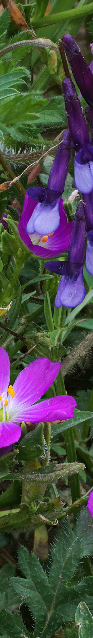
One of the more abundant species blooming in dense patches was azure penstemon, Penstemon azureus, per image above. The saturation and blue hue varies considerably between plants even in the same patch. I hunted for a most saturated blue subject dense with flowers. Notice how color of the lower outside flower tubes changes to purple then white with a bit of yellow? Do you see the white female stigma? Easier to see in the magnified enlarged vertical slice view. Also notice the curving male stamens with light blue filaments that end with pastel anthers containing attached odd white brushes.

PN09058-64 4100x3800 pixels 1 frame 7 image focus stack blend A6000 60mm extension tube diffuser
enlarged vertical slice view
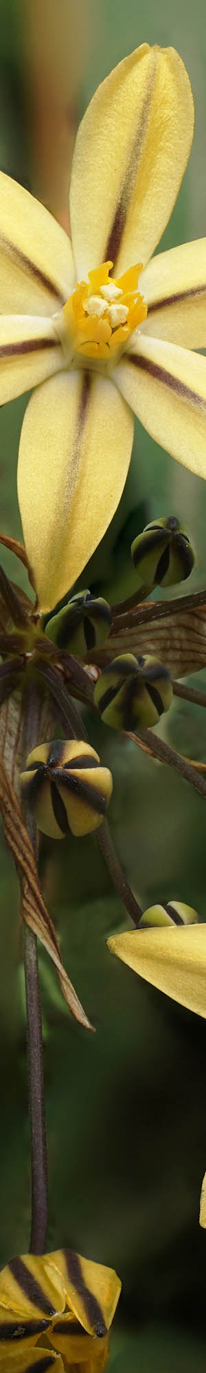
Nearby were also scattered Leichtlin's mariposa lily, Calochortus leichtlinii, one of the large 3-dimensional mariposa's I'd hoped to work so hunted about till finding a very nicely shaped specimen above. The species is most common about Yosemite forest elevations and also about the Jeffrey pine forests of the east side of Sierra.

PN09084-09092-1x2h 5600x6200 pixels 2 frame 1 column 2 row 9 image focus stack stitch blend A6000 60mm
enlarged vertical slice view
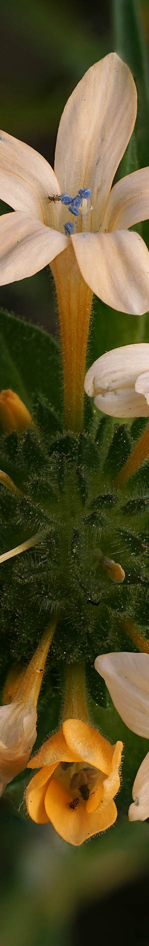
I drove east past the city of San Fransico's Camp Mather that has been shut down undergoing repairs since the Rim Fire. In the past before the Rim Fire, the Strawberry Bluegrass Festival was held each Memorial Day weekend. At the junction I continued beyond a gate that opens at 7am each morning onto Hetch Hetchy Road. A mile further one enters Yosemite National Park coming to the entrance station where vehicle license plates are logged and windshield placards handed out per security policy about San Francisco's water supply. Almost all cars were headed down several miles to the dam parking lot but I would only be driving 3/4 mile to wander about the granite flats of one of my favorite late May areas below Poopenaut Point. Over decades visiting at this time of year, I have never seen another person stop there. Unfortunately found conditions drier than normal and the expected bloom of clarkia williamsonii had not yet appeared. I did stop to work a small stream pool area surrounded by water loving dense white meadowfoam, Limnanthes alba. Mixed in with the white with pinkish tints meadowfoam were scattered white-tipped clover, Trifolium variegatum, and dainty yellow hued opposite leaved tarweed, Hemizonella minima. Within the pool of clean clear water were surface moving water striders.

PN09115-23 6000x4000 pixels 1 frame 9 image focus stack blend A6000 30mm silver reflector
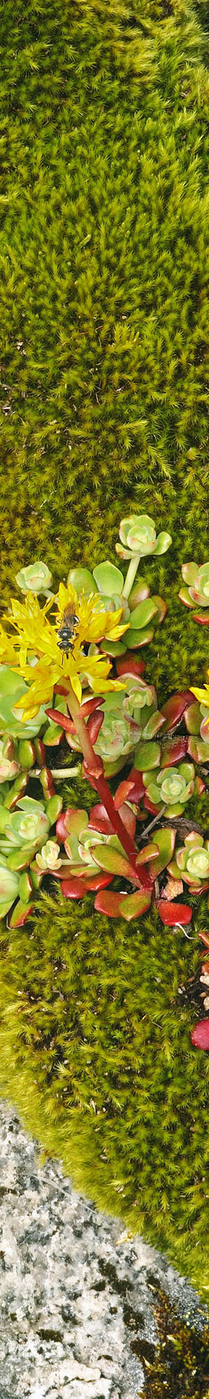
enlarged vertical slice view
Back at my Subaru, the inside of the car had been baking in the sun so immediately opened all the windows while driving further down the road into the canyon. Where one first gets views down into the canyon at 5000 feet there are old granite road cuts on the uphill side of the road blasted by dynamite nearly a century ago that have been colonized by one of my favorite species, Pacific sedum, Sedum spathulifolium, atop mats of moss where spring seeps drain down from higher slopes. The small star-like clusters of flowers are only part of the aesthetic wonder of the species. Like other glaucus sedum species, it specializes growing out of bedrock cracks on steep faces or atop moss covering such rock faces. The spatula-like leaves arranged in rosettes have a range of light green to greenish yellow to cyan, aqua, and red hues. The stems are usually red but can blend into yellow, greens, and even orange. Each spring this area offers a different surprise. On this trip I found an interesting subject above that included a section of lichen covered granite. Frame upper left is a small brittle fern, Cystopteris fragilis, one often finds growing about shady spots on steep bedrock. Subjects like this tend to be considerable more interesting when looking at the full image. Select the enlarged vertical slice view to see a bee enjoying the top of the flower. To improve what was an uneven shaded illumination, I used my 32 inch silver Litedisk collapsible reflector reflecting light off sunlight that was close to shining on the subject.
On the downhill drive past this area, there is no place to park on the right side and the nearest place to turn around is below where the road crosses a small rock bridge of a permanent stream. A small shady parking spot that is worth a stop too because there is a colony of uncommon impressive trillium chloropetalum, just upstream. After turning around one will need to drive to near the top of the sedum section where there are a couple small turnouts. And always be aware of cars because there is little space between the road edge and the roadside slope.

PN09125-09140-1x2h 6000x6400 pixels 2 frame 1 column 2 row 16 image focus stack stitch blend A6000 30mm diffuser
enlarged vertical slice view
Driving back west past Poopenaut Point where the road swings south, it passes by a superb area of canyon dudleya aka live-forever, Dudleya cymosa, on the old granite dynamited road cuts. This relative of the above Pacific sedum also enjoys cliffs and rock cracks though prefers drier substrates and tends to create some of the most picturesque settings of any California plants. I really liked the above subject because besides the textures of lichen and moss in cracks, there were pyroxene mineral surfaces on the granite adding nice rusty orange color.
Forecast thunderstorms were by early afternoon covering the sky east over the Sierra Crest and had backed up west developing partly cloudy skies over this lower zone. Up canyon breezes had also picked up to the point it was useless trying to work these areas any longer. I continued on out of the park and at Camp Mather turned south onto Evergreen Road past Evergreen Lodge that was absolutely overflowing with holiday visitors as cars parked roadside far along the road. It always makes me shake my head when I see so many visitors that come up to mountain parks, once arriving, cluster around climbing on top of each other about shops, eateries, and facilities versus actually getting outside and into nature. On down the road stopped at Ackerson Meadow that is the center of a land use controversy. Land trusts and environmentalists have been trying to purchase the property for years, donating it to the national park, while real estate developers and cattle grazing ranchers have other plans. The moving hamburgers have been using the land for decades and powerful cattle ranching interests have made it politically difficult for county supervisors to do anything that threatens continuing doing so even though it is small potatoes versus vast areas of lower forest elevations cattle already graze. Given the above political issues, private property signs along Evergreen road no longer warn people against trespassing on the land but rather that it is private property with no camping allowed. Thus despite a lack of signage saying such is ok, a good place for visitors to stop and ramble about these interesting forest and meadow lands.

PN09162-09176-1x2h 5800x6600 pixels 1 frame 1 column 2 row 15 image focus stack stitch blend A6000 60mm
enlarged vertical slice view
The meadow areas for landscape photographers have lost much of their aesthetic appeal because the Rim Fire burned through all the surrounding forest leaving ugly blackness, stumps, and scattered partially burned trees that have managed to continue living. However the rich nutrients released by the fire have been a boon to all areas I visited on the trip so a productive area for intimate landscapes and close-ups. Dense areas of sky lupine, meadowfoam, and woolly sunflower covered significant areas. Beneath forest one see lots of big iris. Water tends to pool in some meadow areas early season that creates areas that downingia thrive on and so it was where I shot the above image. Unfortunately by the afternoon breezes had increased enough even in the dense forest about these meadows that I could hardly work any species with confidence usable results were possible. The above micro green jungle with Sierra downingia, Downingia montana, and pansy monkeyflower, Mimulus angustatus, are two small wildflowers but beautiful when magnified by a digital close-up.
Trying to blend focus stacked shots that were shot while breezes moved plants causes element edge mis-registrations even if one waits for calm null periods and shoots at a high shutter speed. That is because at the high magnification these modern digital sensors provide, many moving leaves, stems, and flowers jostled by even slight breezes do not return to exactly the same positions for the overlayed set of shots. Thus if one stacks 7 images and some of them were adequately focused say on a particular flower leaf that moved during 3 shots, each one will overlay that looks much like double exposures from film camera days. Post processing the above image in Zerene Stacker took about 3 hours of tedious work that fixes such situations by selecting just one shot for any elements that have so overlayed. I infrequently commit to rescuing such images and in fact deleted a number of sets shot during this trip because of so.

PN09199-09212-1x2h 5800x6400 pixels 2 frame 1 column 2 row 14 image focus stack stitch blend A6000 60mm diffuser
enlarged vertical slice view
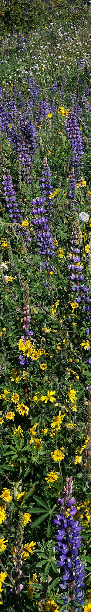
There were a few dense patches of sky lupine, Lupinus nanus, and in the above modest shot included woolly sunflower, Eriophyllum lanatum, in the background. However part of the scene was shaded by pines while the background was in the sun thus impossibly contrasty. So I waited nearly an hour until a cloud finally passed over the frame while breezes were also relatively calm, providing even lighting.
Later Saturday afternoon drove back to Cherry Lake Road aka 1N07, then went down the quite steep paved road into the deep steep sided canyon slowly using second gear. That is where the forest had been densest, the Rim Fire inferno most destructive, leaving the worst ugliness. From there continued north across the Cherry Creek bridge, up through the Granite Creek Basin, then over the broad ridge to Cherry Lake reservoir, all the while surveying what the forest looked like after the monstrous fire and where wildflowers showed. At the dam turned around and quickly made my way back past miles of few wildflowers to the south facing Granite Creek basin where wildflowers have always been abundant and indeed so was the case this day, hiding the blackness below except where black snags poked up through jungle like growth. A good place to disperse camp is where the paved road crosses forest road 1N04. The road west is paved for miles while the road east is a bulldozed nicely flat dirt road logging trucks had been using clearing off areas of burned salvageable timber but has since gone back to loneliness. In other words a fine place to disperse camp atop with little chance anyone else might have reason to drive down it. Hence I set up a car camp about 150 yards east of the junction behind a visually hiding bend where a peaceful night was had.

PN09242-53 5300x4000 pixels 1 frame 12 image focus stack blend A6000 30mm
enlarged vertical slice view
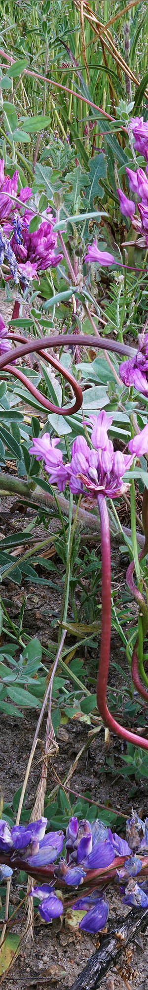
Sunday morning May 29 awoke again at dawn to many friendly tweeting birds, rose up, took care of gear re-arrangements, then visited a couple nearby subjects still in shade, I had sized up Saturday. I was surprised as a rousted black bear apparently startled by my vehicle, ran across the terrain above the road and into the Granite Creek ravine. First above was one of the best snake lily subjects I've ever come across. Twining snake lily, Dichelostemma volublie, has a fascinating vine-like strategy of twisting around other plants and bushes with greater natural stem robustness, in order to stick out up above and beyond into sunny openness. In doing so the result is often quite a sight. Unlike strangling plants, the snake lily doesn't choke its host though the result on smaller plants is often stem confinement. Here three of these snakes have twisted around a single large broadleaf lupine, Lupinus latifolius, peduncle and elsewhere other snakes seem to be grabbing other stems of this large lupine plant that obviously is still in an early stage of its growth with several peduncles rising up showing just buds. This zone of the Tuolumne seems to have an abundance of snake lilies, many times more than I've encountered anywhere else. And broadleaf lupine dominate roadside areas along the road for a couple miles.

PN09347-56 5800x4000 pixels 1 frame 10 image focus stack blend A6000 30mm
enlarged vertical slice view
I drove up Cherry Lake Road to 4420 feet that oddly is the last elevation where wildflowers were prominent. Beyond there were mostly just bush ceanothus species. There at the road bend was a large dense patch of broadleaf lupine mixed with common madia, Madia elegans, and blue field gilia, Gilia capitata ssp. mediomontana. Mixed in were grand collomia, and several other small species like baby stars. The above modest image is a good example of how dense wildflowers were in some areas. Were it not for the marginal breezy conditions, I would have brought back close-up images of a long list of species.

PN09446-55 4400x4000 pixels 1 frame 10 image focus stack blend A6000 60mm diffuser
enlarged vertical slice view
By mid morning I was on my way home with plans to stop along the way. Back up on the Tuolumne Rim near the Mather Road junction walked about in a large patch of mountain pretty face, Triteleia ixioides ssp. anilina, that was atop mountain misery with areas of poison oak rising up within I was very careful to avoid. Thus walked around awhile before deciding to work the above nicely symmetrical subject.

PN09462-70 3500x3400 pixels 1 frame 9 image focus stack blend A6000 60mm extension tube diffuser
enlarged vertical slice view
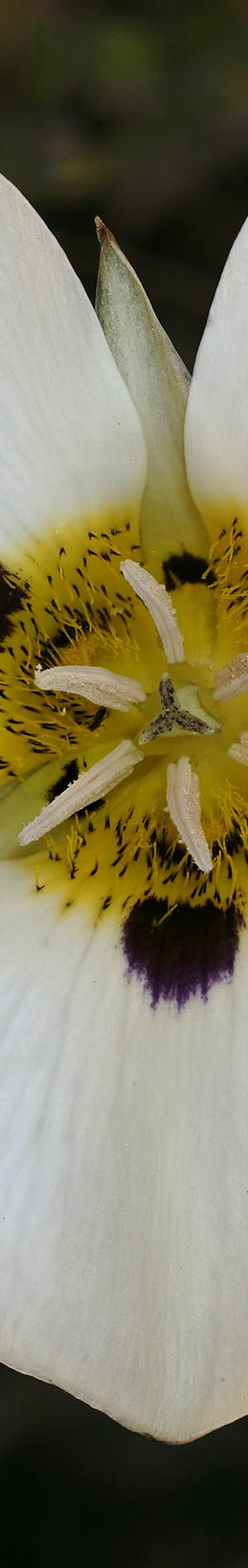
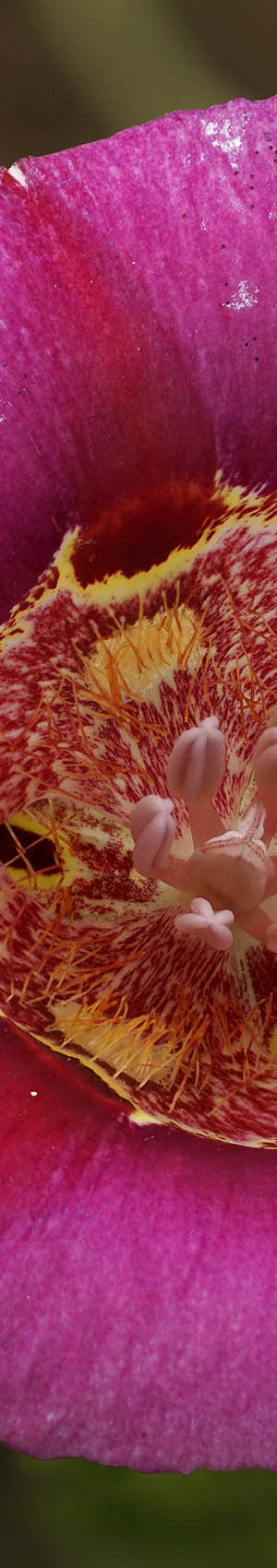
The final subject was a short distance beyond the Mather Road junction where there were abundant butterfly mariposa lily, Calochortus venustus, arguably our most beautiful mariposa species when rose hued. The most common color has white petals though the Jepson Manual lists white, yellow, purple (rose), or dark red. The second most common hue are various rose hues and as I drove down the road a particularly saturated flower caught my eye that I spent a difficult hour capturing per image above while breezes made work difficult. In order to keep the stem reasonably still, used a Tinker Toy tool I built that has a clothespin to lightly brace stems.
Below is a telephoto image taken with my Sony SEL55210 lens from near the junction of Mather and Cherry Lake Roads northeast across at frame bottom the saddle just east of Joes Point that was obviously denuded due to the Rim Fire disaster. The peak at skyline frame right is 9877 foot Richardson Peak with skies above cloudy due to cumulus build ups. At frame left the rounded summit with trees atop is 8464 foot Nance Peak with Edyth Lake in the canyon 2200 feet below its steep cliff face, I visited Edyth in September 1979. I had stood atop Nance in late June of 1979 while on a day hike out of my backpacking camp at the beautiful Spotted Fawn Lake. The canyon between Nance Peak and the noted saddle at frame bottom contains Cherry Creek. The long level forested ridge lower and just right of the noted cliff face is the ridgeline just south of Lake Eleanor reservoir. Thus the brushy with rocky outcrops treeless area in front of that ridge is part of the Miguel Creek drainage. Also to the right of Nance Peak some miles in the background is 10365 foot Grizzly Peak. On the left ridgeline of Richardson Peak are some pointy peaklets. Below those peaks the mixed forested and rock hill is topo point 6831 just southwest of Laurel Lake that is down below to the right in its tall forest. That was the destination of my first ever backpacking trip on Memorial Day weekend in 1972. Frog Creek flows through the hollow between those hills that is Yosemite's prime black bear land. Bearup Lake I also visited in 1979 by climbing up from Edyth, would be below the east side of Richardson Peak in that shallow canyon.

NEXT:
Page 9 Tuolumne Rim/Glen Alpine Backpack
2016 Trip Chronicles: Contents