
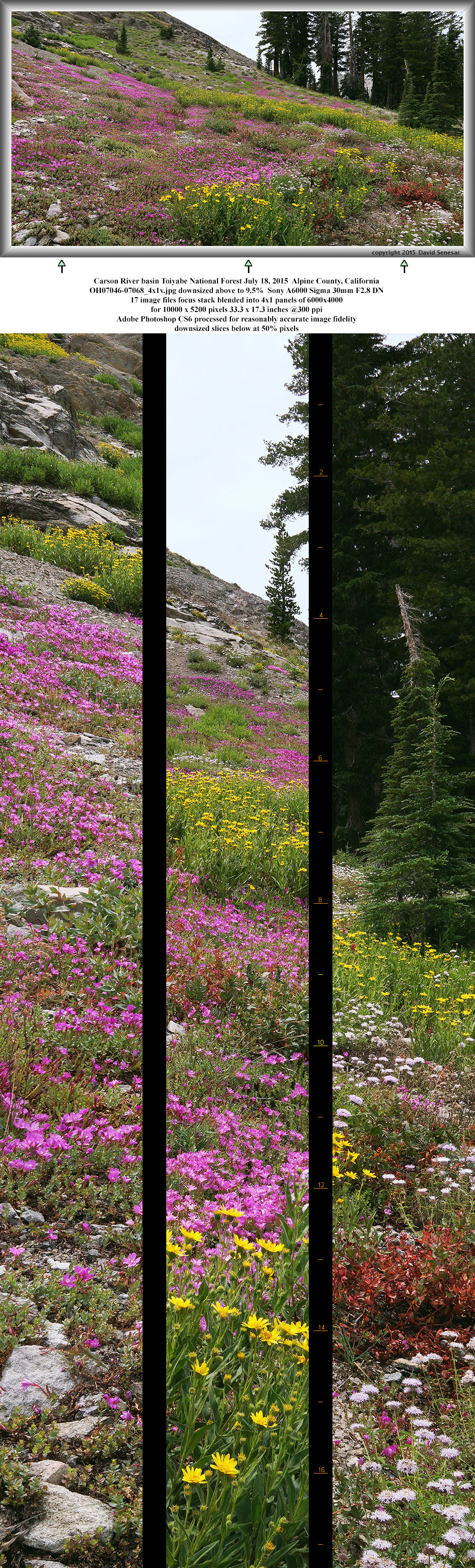
OJ07046-07068-4x1v 10000x5200 pixels 4 frame 4 column 1 row 23 image focus stack stitch blend A6000 30mm
enlarged vertical slice view
NEXT: Page 12 MF Bishop Creek
2015 Trip Chronicles: Contents
West Fork of the Carson River 7/18
Hall Natural Area Lee Vining Creek 7/24
Hall Natural Area Lee Vining Creek 7/25
The Friday after returning from our long Fish Creek backpack on July 17, I drove back up into the Sierra after leaving my Silicon Valley 8-5 m-f work place late afternoon. The destination was an area near Carson Pass in the West Fork of the Carson River drainage I wanted to visit earlier at the same time we were down at Fish Creek. When peak wildflower blooms occur in the range, they are of course peaking at many locations at similar elevations and exposures but a photographer can only visit one location at a time. Thus choices must be made and my strategy is to within a short period of weeks drive up on a few consecutive weekends. Though a single week can make considerable difference, the nature of species succession is such that there is never a peak bloom over all showy species of interest but rather each species peaks over a range of dates depending on its particular environmental needs that vary a bit summer to summer. In the best years after abundant winter precipitation, many species are synchronized while in mediocre years species one hopes to see at the same time may not overlap at all. This makes the photography game more interesting and challenging. A person without much experience or meaningful strategy can simply drive up and get lucky. However someone with long years of experience and natural science study can do much better. These are enormous areas and all my visits over the years don't amount to more than familiarity with tiny areas of landscapes leaving vast unknowns.
The Carson Pass region is one of volcanic geology with richer soils and more long lasting water draining through its deeper sediments. But conversely it also has lower elevations versus the granite High Sierra to the south that are apt to dry out sooner due to higher temperatures. My strategy in order to catch remaining blooms was to visit one of the highest north facing basins in that zone. The actual highest area was about the very popular Winnemucca Lake trail to the north exposures of Round Top and Elephant Back. But I've already visited there several times during wetter years so this droughty year that area would not show this person anything better than what I've already seen. I gleaned a bit of vague information off current web reports and in the end made my decision while on the long familiar drive up. An online topographic map of the Carson Pass region:
With dawn lightening skies on Saturday July 18, 2015, I rose from an obscure back road in Toiyabe National Forest then organized gear into my daypack for a long morning of work. Skies were totally cloudy with NWS technical forecast discussions showing modest chances of showers in the area especially early. Thus into the pack went my rain gear. For most landscape situations, sunny blue skies render the best results however with colorful vegetation like with fall leaves or summer wildflowers, cloudy diffuse light conditions despite being boringly flat, can be better if one fills frame areas with those colorful elements instead of the usual balance of peaks, lakes, forests, skies. I had some cross country distance and climbing to do that I expected to be rather straight forward without complications. After working through a section of dense dry lodgepole forest, I worked up through areas of stream and small meadow that were lush with past peak flowers, many well over head height. Within an hour had reached the target zone and immediately knew the morning could be productive.

OJ06813-06836-4x1v 11000x6000 pixels 4 frame 4 column 1 row 24 image focus stack stitch blend A6000 30mm
enlarged vertical slice view
The Carson Pass region, both north and south of the pass is famous for having some of the finest wildflower displays in the Sierra Nevada range that in most summers peaks mid to late July. After one of the driest years in history, the peak generally was late June into the first week of July. In the image above about a willow surrounded pond, the dominant species are the tall white hued corn lily, Veratrum californicum, a late blooming species that was only about a week beyond peak. If one opens the link to the enlarged vertical slice view, also in the foreground are considerable more past peak and ragged red hued Applegate's paintbrush, Castelleja applegatei, light lavender hued mountain pennyroyal, Monardella odoratissima, yellow hued soft arnica, Arnica mollis, yellow hued alpine goldenrod, Salidago multiradidata, and striking magenta hued rock fringe, Epilobium obcordatum. And if one looks closely even a few alpine aster, Aster alpigenus var. andersonii, crimson columbine, Aquilegia formosa, and Brewer's lupine, Lupinus breweri. Trees in this image are whitebark pine, lodgepole pine, and mountain hemlock. And yes that is virga hanging down in the background sky.
Streams in the area were also lushly dense with species though as with image below, broad-leaf lupine, Lupinus polyphyllus, that usually dominate such intimate landscapes, were looking rather ragged past peak with more brown seeds showing than flowers. That kept me away from setting up my tripod for any serious shots as there will be much more optimal situations during future summers. Also in that streamside jungle are soda straw, ranger buttons, tower larkspur, blue flax, pennyroyal, corn lily, and paintbrush. Although I have imaged such scenes for years, as camera and photographic software technology advances, much of my older work becomes second rate compared to what can be captured currently. Today focus stack blending, frame stitching, luminance dynamic range, and the speed of sensors is a huge advantage in producing large highly detailed wildflower landscape images versus my large format film work just a few years ago.

The one species that was right at peak making this single day road trip successfully productive was the beautiful highly saturated rock fringe, a favorite species of wildflower seekers. My go to lens for close-ups is not the Sigma 30mm F2.8 DN lens that were used in most of these landscapes but rather the Sigma 60mm F2.8 DN which allows longer lens to subject distance and I've tested with an Edmund's Scientific USAF 1951 pattern resolution test chart as slightly sharper. A variable minor breeze was increasing during this morning and that made work like the close-up below more an effort. I carry both a 32 inch collapsible circular diffuser and 32 inch collapsible circular silver reflector. For situations like this, both are often open surrounding subjects simply to block breezes minimizing plant movement. Each time a breeze moves leaf, stem, flower subjects like this while trying to capture a focus stack set of frames, there will tend to be slight changes in relative positions of elements that readily show at full image detail. And this below image contains 10 frames each with a different focus point. The only way to fix that in post processing is by using a tedious tool like Zerene Stacker else results are utterly hopeless. For most close-up frames I use the optimal balance of optical sharpness and depth of field F10 or F11 aperture while for less subject important sections like the deeper more shadowed sections beyond the flowers, will close down more to F16 or F18. If conditions are nicely calm will tend to use the sensor's top ISO 100 but if elements are moving around a bit ISO 200 and beyond that will consider breezes just too unworkable. If you look at the enlarged vertical slice view at frame bottom, one will see a black ant, very active insects at this abundant time of year.

OJ07011-0 6000x4000 pixels 1 frame 10 image focus stack blend A6000 60mm
enlarged vertical slice view
Up and down, around and about, I ramble across terrain in areas like this searching, not satisfied with just what may be easily visible because sometimes that extra effort into promising areas surprises with landscapes like at page top. The exposure and nature of the area looked promising on the topo. After a couple similar climbs without finding much interesting, I hit this jackpot. Easily the largest expanse of rock fringe I've ever happened across. Along with the rock fringe are dense areas of yellow hued soft arnica and pennyroyal, a common sunny landscape mint species that may have the strongest fragrance of any of our Sierra species. And in these volcanic landscapes pennyroyal dominates odor everywhere. In this particular area I also found patches of Sierra primrose that has similar deeply saturated mageneta petals but peaks earlier. Well that is when flowers first open from their buds as most flower colors gradually bleach day by day from sunlight. Thus will return during a future summer at a bit earlier phase of blooming after more normal winter snows when the two species blooms are more likely to overlap.
During the following work week I wondered where else I might visit the following weekend of July 24/25? Was there a backpacking destination worth some effort? Given the waning wildflower conditions my motivation to do anything was rather low with a strong inclination to stay home, rest, and just work on post processing and web features I was weeks behind on. Beyond this current week the grassy turf areas would increasingly show unaesthetic yellows and browns I have little interest in. Well until late August when turf high dwarf bilberry and arctic willow start their fall leaf changes. By the end of the week I was in much the situation as the previous week, uncertain with a few not too exciting options. The Tioga Pass zone allows getting up to maximum altitudes without too long a drive for this person. Weather looked like a gamble. Saturday likely a bit too breezy for lake reflections since a trough was moving east over Nevada into the Rockies while Sunday maybe ok? I scrutinized jet stream forecast 2:10 PM 10/3/2015maps.
The work week ended, at 5pm Friday got into my Forester and began driving east so whether I actually felt like enduring yet another road trip or not, I seemed to be on my way. And after another familiar boring drive of several hours, by 11 pm was parked in the usual community at the Warren Fork 9k bend on SR120, where I slept soundly within my car's cushy back bed setup. It was going to be either 20 Lakes Basin or some exploring about lakes in the Hall Natural Area. The former in the very popular basin above Saddlebag Lake I'd visited several times over the years in the past and have an abundance of strong images for while the latter not much at all. My last visit was in fact late spring after SR120 opened up when I skinned most of the way up White Peak in order to get some corn snow turns in. Both areas have fine areas of colorful metamorphic geology and permanent streams flowing out of small permanent glaciers and snow fields.

Saturday July 24, 2015 at dimmest dawn drove off the short miles up onto the Saddlebag Lake gravel road then parked at "the meadow" parking lot midway up that road where 3 other cars had overnighted on the sly. Such is per regulations considered "camping" thus illegal in national forest or blm areas where dispersed camping is not allowed. There is not much enforcement due to lack of manpower so as long as people don't tent or toss sleeping bags down beside vehicles, or large RVs don't start setting up their usual roadside furniture, and no one complains, Inyo tends to look the other way.
Yikes it was chilly as I got out making a racket organizing my gear. The nearby meadow looked very frosty and condensing fog hovered over the ice cold creek waters. Dawn light had increased so I would not need my headlamp and with a full load in the daypack, headed out. The first task was to find a way across the creek without having to wade which meant locating a section in the miles long meadow where it spread into multiple branches I might then jump or rock hop across. That took some effort and in the process bottoms of my Levi 501 jeans were picking up water from the frosty willow thickets I was wading through. Eventually found my way across with just my Gortex Bitterroots dipping into waters then endured heavy breathing climbing through moderately steep slopes of a rocky lodgepole pine forest topping a ridge and into the Harvey Monroe Hall Natural Area lake basin where there are numbers of both small named lakes and even more ponds and stream pools. The special management area is for botanical research by Carnegie Institution of Washington. Within that zone no overnight camping is allowed, only day hiking.
Sun was now shining on east facing slopes of the Sierra Crest above the lakes but light was still too early for any landscapes with lots of shadows. I surveyed some lake, stream, and pond areas for possible subjects but a chilly breeze made those waters a probable waste of time. So looked about for interesting wildflower expanses in the meadows along streams but was disappointed that wildflowers numbers were mediocre. Looking at my topo, I decided on an exploratory tour of several higher lakes on the towering ridge that forms the Yosemite park's eastern border and is part of the Sierra Crest. Waters on this eastern side flow into land-locked Mono Lake while those west of the crest eventually into the Pacific Ocean. And so I expended effort climbing up steep rocky slopes. As the morning progressed it just got windier. By the end of the morning found some modestly aesthetic lake landscapes I might work in calmer conditions, and one jackpot. It looked like I would be making a second visit on Sunday morning to the one lake. On the way back to my car took a refreshing dip in the cascade through bedrock at image right
The rest of my day was about amusing myself and resting after the long tough morning ramble. I drove down to Lee Vining and bought one of those fat juicy cheesy pepperoni pizza slices at the Whoa Nellie Deli in the Mobilmart. Mono lake itself was all waves so of no interest. Before sunset I was back up at the Warren Fork bend where as an early arriver had my pick of a prime spot to park at. Opened up a can of Campbell's spaghetti and meatballs for my Whisperlite to heat up then comfortably retired into the Forester.

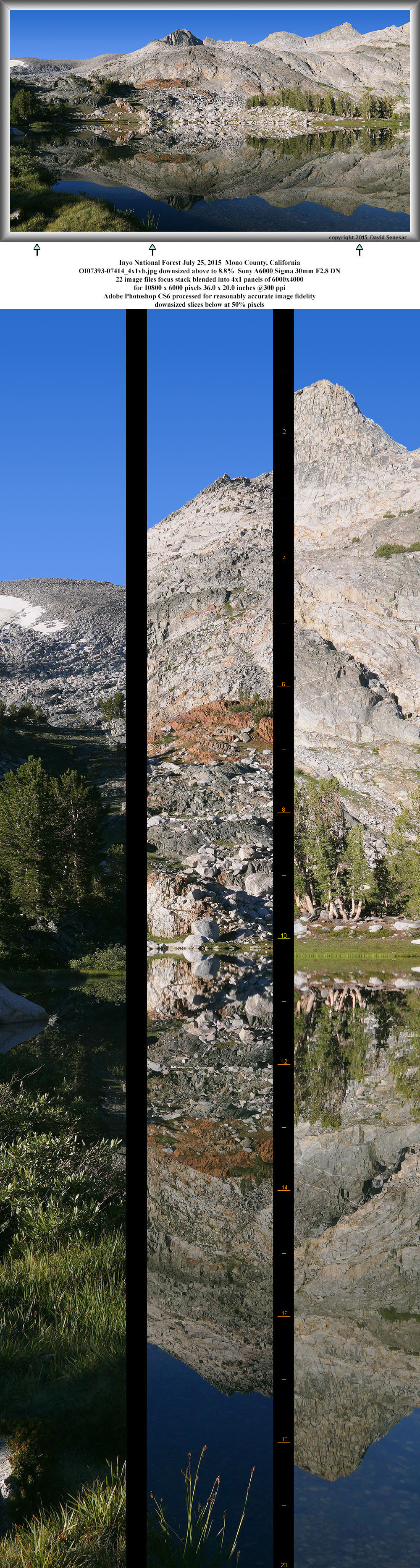
OK07393-07414-4x1vb 10800x6000 pixels 4 frame 4 column 1 row 22 image focus stack stitch blend A6000 30mm
enlarged vertical slice view
Dawn arrived on Sunday July 25, 2015 and with a carefully analyzed plan for cross country travel drove off to a different parking spot on the Saddlebag gravel road. Once again I sped off into frosty meadows but this time with a specific target destination. Was glad to find weather indeed pleasant with calm conditions though did not trust what might be conditions at Sierra Crest ridge top altitudes. Anything on that crest tends to be breezier than other places in the range as air masses on the east side of that dividing terrain balance weights of air with those on the west. So it is not uncommon to find earliest mornings calm that rapidly changes as the cold heavy night air filling the valleys gets pushed out by the disturbing influence of warming morning sunlight on slopes. Within an hour I had reached the magnificent lake waters then was quick to set up camera gear and fire off frames that make the above 10800 by 6000 pixel 4x1 vertical frame panorama. The backdrop of the lake had the same fine bands of colorful metasedimentary geology one sees at Wasco Lake above Saddlebag. There was also interesting large talus and greenery of turf and whitebark pines. All 3 images in this section feature this same slope but from different perspectives. A place I will return to in the future a bit earlier in the summer sequence with more snow adorning its rocky slopes. And there are other subjects I'd found in Saturday's ramblings also worthy of a return when conditions are optimal.

OK07491-07511-4x1vb 10600x6000 pixels 4 frame 4 column 1 row 21 image focus stack stitch blend A6000 30mm
enlarged vertical slice view
This second image above of the slope was from the far end of the lake in order to better reflect slope rock elements.

OK07542-07557-3x1v 8300x6000 pixels 3 frame 3 column 1 row 16 image focus stack stitch blend A6000 30mm
enlarged vertical slice view
And for this third image above, climbed up onto a high rock near the bottom of the slope capturing the interesting lay of talus boulders on the colorful bedrock.

OK07512-07539-4x1v 11200x6000 pixels 4 frame 4 colum,n 1 row 28 image focus stack stitch blend A6000 30mm
enlarged vertical slice view
Another lake reflection in the Hall Natural Area with a fine turf lake edge. At lower left frame edge was a disturbance at the water's edge that was a mystery as it hid when I walked over to see what it was. Maybe a frog? There were no trout in this lake.
NEXT: Page 12 MF Bishop Creek
2015 Trip Chronicles: Contents