
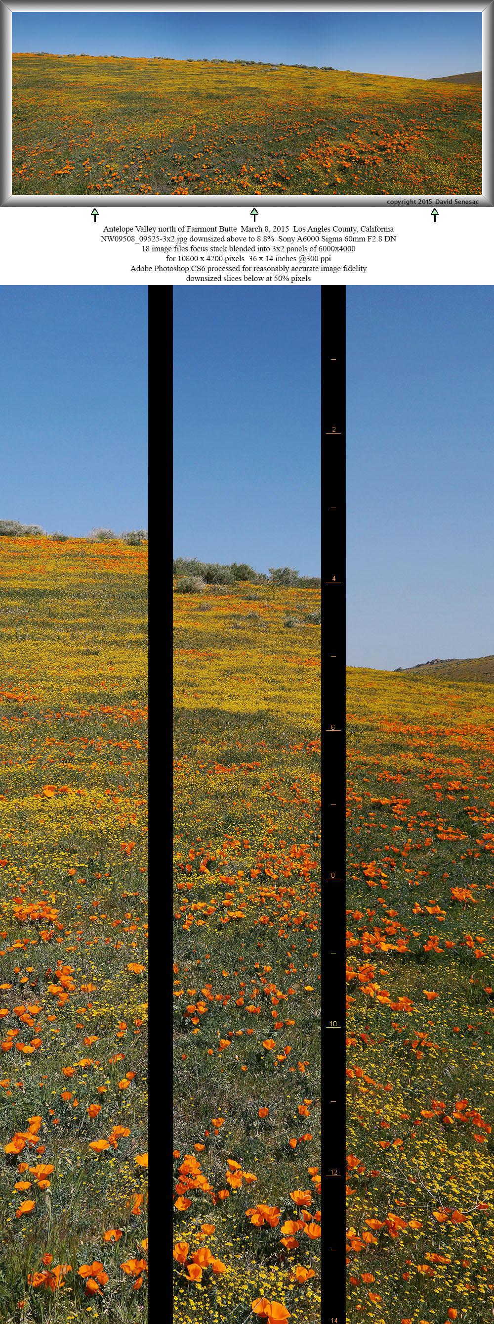
NW09508-09525-3x2h 10800x4200 pixels 6 frame 3 column 2 row 18 image focus stack stitch blend A6000 30mm
enlarged vertical slice view
NEXT: Page 3 Antelope Valley Carrizo Plain
2015 Trip Chronicles: Contents
Riverside County 3/7
Antelope Valley 3/7 1of2
Antelope Valley 3/8
The situation down in Southern California became interesting despite yet another droughty winter. Knowing where, when, and how much annual wildflowers will bloom each spring in our arid desert lands though complex, most importantly requires understanding two most significant factors. One is where are the historical seed beds of wildflowers? And two, where, when, how much rain has occurred at those specific areas. A particular area might receive heavy precipitation but if there are few seeds on the ground, at most just those few seeds will bloom. Of course in places that historically have had dense wildflowers, there are also likely to be dense dormant seeds just waiting for a wet winter. Thus the task is to find where there have been heavy rains and where plants have historically made a showing in best years. Of course it is more complex but those are the main two elements to key on.

There are many less known or unknown locations which are not likely to receive public reports that simply require experience visiting these regions with exploratory road trips over a period of years. Some locations like the Antelope Valley California Poppy Reserve are well known, are always reported within online reports, and have not only onsite personnel providing periodic reports but also enthusiasts are likely to visit early during a season then provide trip reports. The better strategy is being able to predict from preliminary reports when peaks might occur instead of waiting for others to actually report such online because windows of good conditions sometimes last just days. And that is exactly what happened this year of 2015 that had localized areas of spectacular blooms that few visitors much less serious photographers managed to experience the brief peak bloom for.

All winter I'd been keenly monitoring precipitation at numbers of online weather profession sites plus various online condition information boards and sites. By mid February that showed the majority of our desert region wildflower locations would not have much to offer because better precipitation during this droughty winter had been spotty. A few things did stick out and most importantly was that the Antelope Valley California Poppy Reserve received over 4 inches of rain during December then another good inch mid January from a humid Baja system. On February 13 and again on February 20, I posted Yahoo Groups calphoto heads up messages to park website reports coming from resident AVCPR plant specialists stating it appeared the best bloom in years was imminent.
However 6 weeks of dry conditions had returned putting big IFs in the interpreter's comments and in my own mind. Then on February 23 a storm with heavy spotty rains hit the south that seemed to add a third to half an inch to that region. Maybe enough to trigger a goldfield bloom absolutely necessary to make any blooming poppies landscapes aesthetic? Droughty conditions were such that a delay till the more typical peak about end of March could mean missing whatever bloom entirely. Or poppies might be out then but without fresh goldfields that would leave these landscapes relatively boringly brown. Now or never, began looking ahead to trigger a road trip to the south. I knew from experience that a delay of about a week was necessary to allow any water actively emerging plants absorbed to translate into blooms.

The Antelope Valley is much a wind funnel driven by hot daytime rising desert air to the more arid east or heavy coastal marine air finding its way over the low coastal mountains to the west or any winter frontal system air pushing down against the Tehachipi Range from the enormous San Joaquin Valley to the north. Hundreds of large white wind mills tower into the sky about several areas attesting to those winds. Thus it can be disgustingly frustrating to pro landscape photographers trying to image foregrounds of colorful flowers. Out of focus foreground elements are simply unacceptable to serious photographers that produce large prints meaning one needs to somehow avoid windy days.
In years past, without much in the way of wind weather forecasts available, a strategy was to allow enough days during visits that at least one day might be usable. In this Internet era, one can monitor jet stream forecasts at virga.sfsu.edu and modeled weather charts showing isobars. Also wunderground.com now has very useful 10 day graphic wind forecasts. A week before that pointed to a window of wide isobars about the March 7 to 10 time frame so at short notice, I pulled the trigger to take 3 days of PTO from my 8-5 m-f hi tech work in the SF Bay Area. My plan was to first drive down to Riverside County to look at obscure areas worked in 2008. Spotty heavy rains had drenched parts of that region with as much as 4 inches during the February 23 storm. But did any of those heavy rain cells water the limited locales I knew to have dense seed beds?
The start of my long drive Friday late afternoon March 6 began tragically sad. South of the Panoche exit on I5 going 70 mph in the right lane and with a big rig barreling along behind maybe 200 to 300 yards, a modest sized light white dog suddenly dashed across the two lane freeway. I had about a second to react. My 2007 Forester hit the dog with a truly awful car shaking thud about the left front bumper and was shot back swirling on its side in circles into the left lane, legs sticking out motionless. For a few seconds I wondered about immediately stopping to do anything for the animal while listening to any signs my vehicle was damaged. In my mind I knew even if the dog had not been killed outright, that it would be so internally mangled by the crushing blow that putting it out of misery would be the only action. In seconds more at 70 mph I was so far down the road the notion of stopping became only a growing guilt. Looking back I could see many other vehicles and big rigs some of the later of which would have likely soon finalized the nightmare.

The area is one of the most remote sections of the interstate with hilly remote oil production and grazing lands where for miles one does not see any ranch homes. Although I wrote dog, it was probably a coyote. The largest animal I'd ever hit before was a squirrel or jackrabbit so this as an animal loving person had a painfully shocking effect. Had I at first instant veered to the left directly at the moving dog, might have missed it if it continued across as it did. However if the dog had looked up and stopped, I would have been more responsible by veering at then hitting it. In decades of driving in rural areas had always managed to avoid hitting deer because my usual awareness and reaction times are fast. Many animals like squirrels, deer, and house cats once they decide to dash across a road, are single-minded in their determination to continue regardless of what is approaching. My own emotional state was of no concern as the only pain that mattered was that of the unfortunate creature. Yes we humans are destroyers of animal life on our planet and now I David was a very guilty participant. My bumper was cracked and hanging out from its seating. Was able to kick that back into place. And the top of the windshield wiper reservoir was cracked such that a gallon of water spilled out.
With a sick feeling inside, spent the next 3 hours going around in circles to the east in Fresno. I considered driving back home ending the trip, but then what would I do for 5 days? In front of a late evening AutoZone store also took a more thorough look for any vehicle damage especially about my coolant radiator. Well that seemed ok. Thus turned around again continuing on south down US99. About 1am pulled into the I5 Tehachi Pass Roadside Rest at Lebec about 300 miles along and soon was asleep in the back of my car where I have a comfortable sleeping set up.
With 4+ hours of sleep, at dawn Saturday March 7, 2015 was soon continuing south into my region of birth decades before, the City of Angels. The dog was still swirling about in my waking mind. By mid morning had reached the Lake Elsinore area exploring familiar back roads, filling my mind with the task at hand. Though some areas were covered in goldfields, it was noticeably droughty in comparison to my 2008 incredibly lush visit, Spring 2008 Wildflower Trip Chronicles (page 7). A sad sign of these times, numbers of rocky outcrops now were covered by graffiti spray paint.
No those spotty heavy rains did not do so in target areas but rather further to the southeast in a more urbanized zone. Over a couple hours explored some back road areas per plan and the gamble in the south was over. Began to wonder if things would get worse? Would I find Antelope Valley too dry, then too the Walker Pass region, then too Carrizo? Make a reasonable gamble, learn something, cut losses, and move on. By noon had crossed back north out of the L.A. Basin on I15 into Antelope Valley on SR138. There drove north to Saddleback Butte State Park that was as dry as could be expected from its meager rainfall totals (see graph above), a few areas of yellow goldfields in a sea of brown dryness. However due south the northern flanks of Old Baldy at 10,064 feet still held white snows.

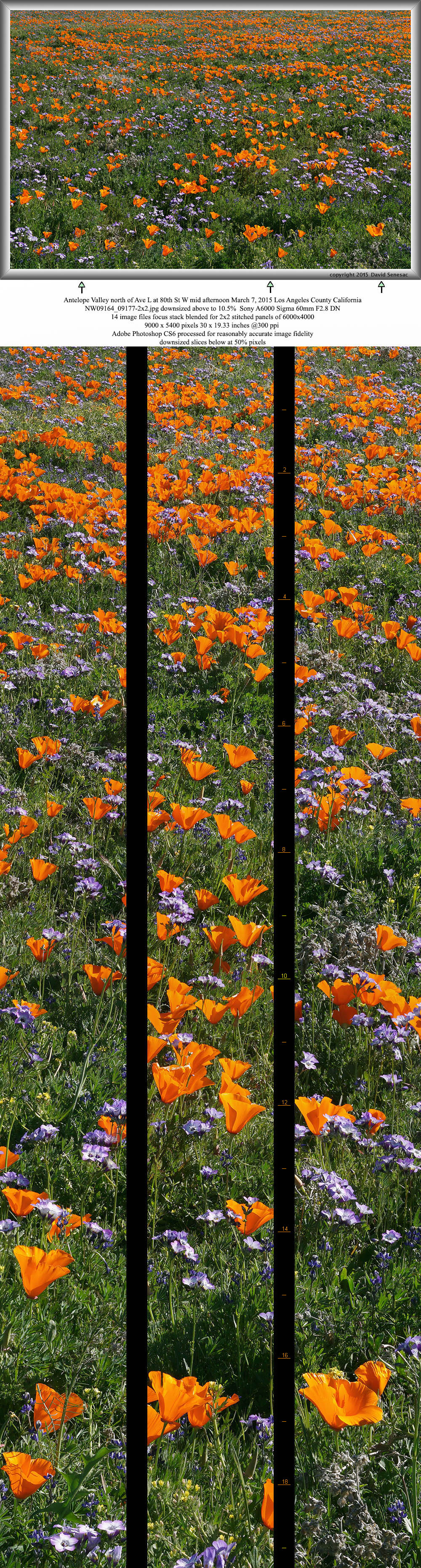
NW09164-09177-2x2h 9000x5800 pixels 4 frame 2 column 2 row 14 image focus stack stitch blend A6000 60mm
enlarged vertical slice view
Continuing west on Ave I East under sunny skies with light breezes, soon reached Lancaster where landscapes appeared a bit greener. It was time for some fast food lunch and a market stop for drinking supplies since wildflower areas were at least 15 rural miles to the west. I topped out my 5 gallon water container from a Palmdale city park faucet two quarts at a fill. Later driving west immediately could see a large orange poppy patch above 80th St W and Avenue L on the sloping plains at the foot of Portal Ridge to the south. It was in a familiar area just west of Quartz Hill that has had flowers for years below power transmission towers at elevation 2750 feet or 400 feet higher than the plains below. A good sized purple blue patch amidst the orange signaled phacelia or gilia and that turned out to be Davy's gilia. About two dozen vehicles were about its maze of dirt roads that is just west of tract houses. Arriving it was rather obvious people must have just started to visit the area within the end of this week because few foot paths were visible and plants were showing their first flowers with many still in bud. Well I'd found a good area of flowers now and was confident if nothing more this area alone could support a couples days of work.
On image above, set up the Gigapan Epic robotic head for a 2x2 panel downward plane image with the 30mm lens of Davy's gilia, Gilia latiflora ssp. davyi, amidst California poppy, Eschscholtzia californica. Also one can see yellow hued slender keel fruit, Tropidocarpum gracile, and small blue hued pygmy-leafed lupine, Lupinus bicolor. All these plants were lushly robust indicating at least this local area had received more precipitation on February 23 than the nearby Lake Palmdale remote gauge on the web. Set up a couple more images that turned out nicely though tall metal towers and housing made landscape situations limited. However at image below, found a shallow wash away from the towers with dense lush vibrant poppies then managed to put its near slope up in the sky to the west with a 2x2 panel using the 60mm lens. It was reassuring to experience only intermittent minor breezes on this first afternoon of my road trip showing forecasts to be valid. These large poppies would easily be the most robust plants I would encounter on the trip reminding me of what poppies in the region really looks like during wet years.

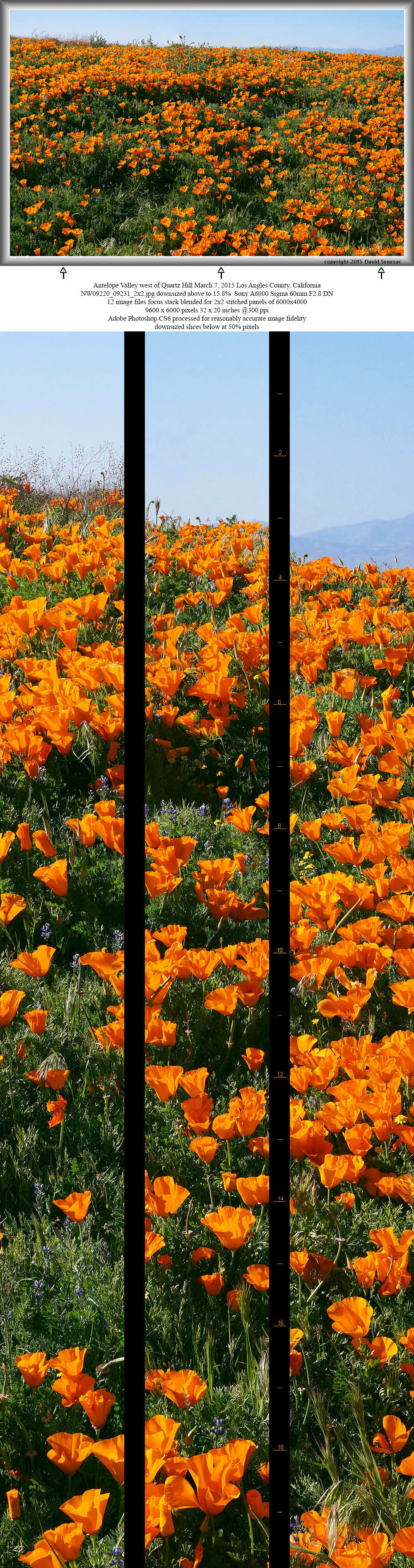
NW09220-09231-2X2h 9600x6000 pixels 4 frame 2 column 2 row 12 image focus stack stitch blend A6000 60mm
enlarged vertical slice view
Late afternoon continued west then south up and over Portal Ridge on 110th St W/Johnson Rd to the Elizabeth Lake area which lies in the bed of the San Andreas Fault, then back north on Munz Ranch Road. Those areas did have flowers however less than on average years and given higher elevations it was early. Good numbers of Saturday visitors were parked along Lancaster Road on the approach to the Antelope Valley California Poppy Reserve, roaming through modest flower fields. Swung around to the dirt part of 160th St W that follows the western reserve fence boundary north and where the boundary turns right east becomes puny dirt Avenue F8. On that northern boundary of the reserve were significant areas of solid at peak flowers of several colors that could alone keep me busy for a couple days. All these plants were however water starved stunted with a sun baked drying look unlike those at 80th St W. Got out and took a couple modest image sets though poppies were rather curled up. Hmmm? At this point would divide tomorrow's work up between the Quartz Hill patch and here. I was feeling pretty good about Sunday though conditions were a few notches below what we'd worked in better wet years. But then near sunset drove around to 170th St W and into Broad Canyon which was jaw-dropping with wonderful multi-color layering despite drought stunted plants. WOW! Ok scratch that earlier notion and instead would work these landscapes. Yeah I was now excited.
Time to set up a dispersed camp and having spent several road trips in the area years past knew just the place nearby. A mile north, two miles east, and half mile north and was out into a remote Joshua tree forest north of SR138 on 150th St W where one never sees other vehicles. A place to drive carefully on its degenerating dirt roads because for decades in the past, was apparently an area for gun target shooters thus target trash and broken glass was about. They would never use the area again because not far away now were acres of solar farm arrays. It is also a conveniently nice area for dusk and dawn sky joshua tree, Yucca brevifolia silhouettes.

NW09317-0 6000x4000 pixels 1 frame 4 image focus stack blend A6000 60mmenlarged vertical slice view
At this equinox time of year with a long night, it was easy to get back hours of sleep I'd missed the night before. By 5am that was about 9 sound hours and had slept enough so began organizing my gear inside the Forester. When sunrise broke just before 7am PDT Sunday March 8, 2015, drove back south with a plan. Note this was the first day of daylight savings time here in California. Skies were sunny and only a slight intermittent breeze promised excellent conditions. There was little value in immediately going to the poppy flower fields because they remain curled up until about 10am. Additionally wildflowers in landscapes display better saturation when side lit after the sun rises up to at least mid morning altitude. Early and late light photography enthusiasts may think different but that is only by being heavy handed with saturation controls during post processing with what visually to the eye is rather boringly flat.

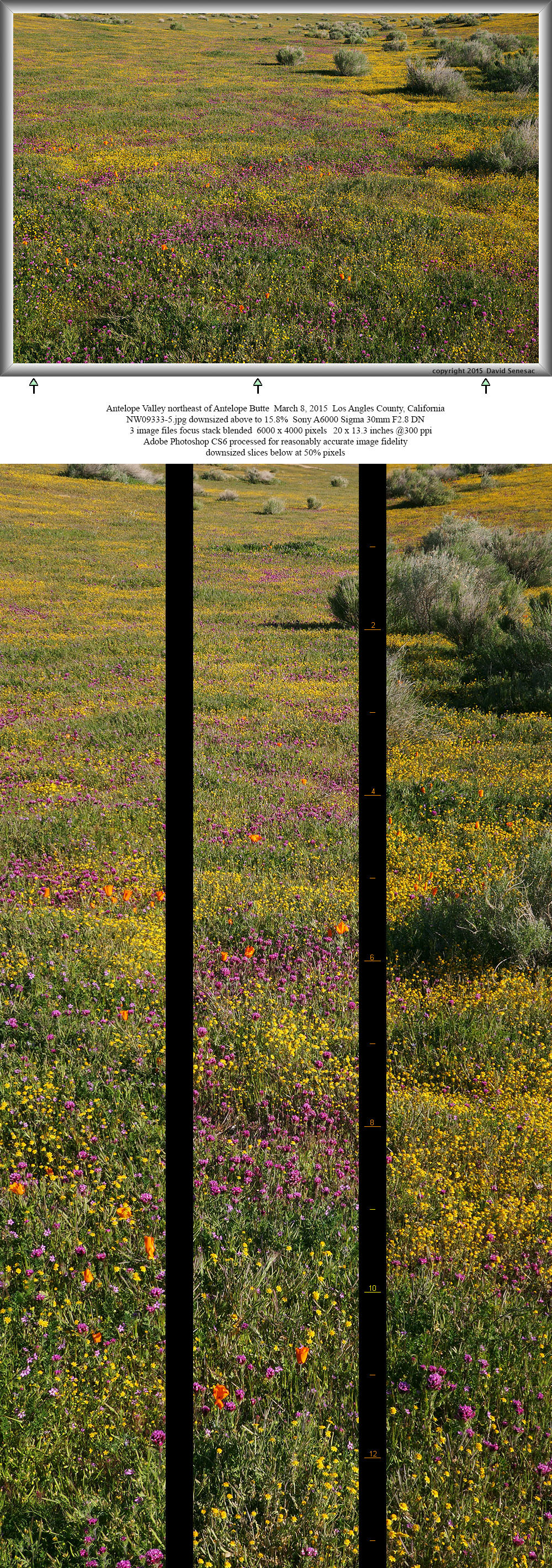
NW09333-35 6000x4000 pixels 1 frame 3 image focus stack blend A6000 30mm
enlarged vertical slice view
Thus had time to explore a maze of dirt 4WD roads southeast of the AVCPR that showed vast expanses of goldfields, Lasthenia californica, amid rabbitbush, Ericameria bloomeri, plus lots of ORV tracks. Here and there were modest areas of the full mix of species at AVCPR though poppies were scarce and purple hued owl's clover, Castilleja exserta, more numerous per image above captured just after 9am PDT. Generally owl clover put on their most impressive blooms in much wetter years. Notice how the few poppies are indeed still curled up. Also notice how the height of species are similar which was due to drought stunting. Almost looks like one could use the surface as a colorful golf putting green. The even heights actually provided more aesthetic mosaics of color in some of my images below. Another oddity of this spring was the myriad redstem filaree that tend to outgrow other native species in early winter had apparently been inhibited by the very dry hot January weather and were still just inches high. The alien filaree can also negatively affect the aesthetic of other species as soon as they go to seed because they tend to turn a murky brown.

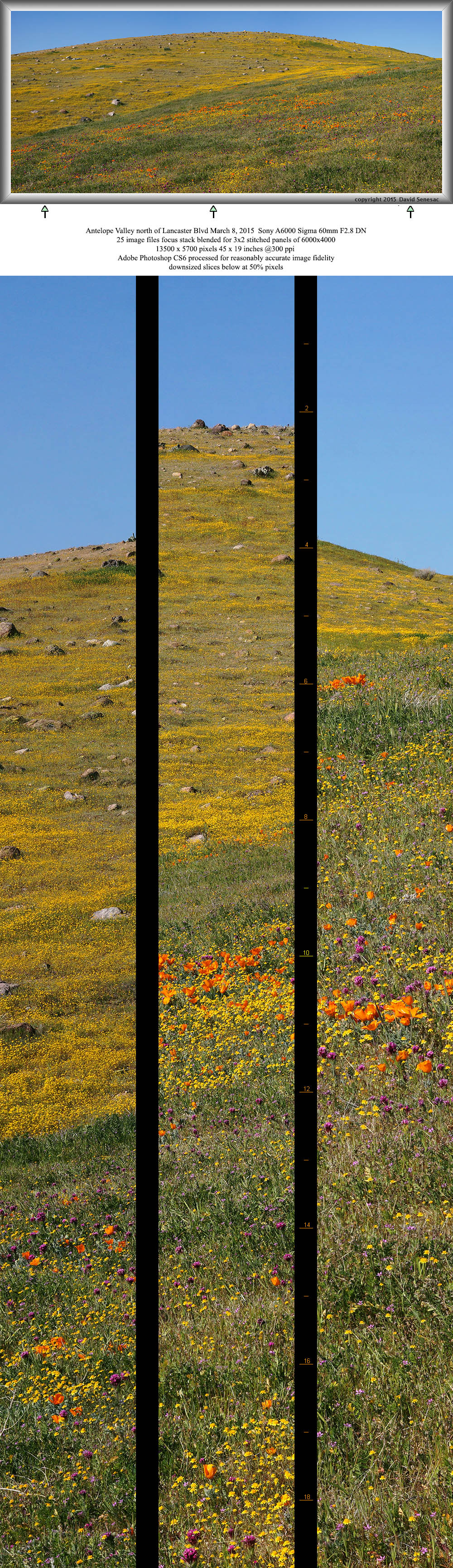
NW09368-09392-3x2h 13500x5700 pixels 6 frame 3 column 2 row 25 image focus stack stitch blend A6000 60mm
enlarged vertical slice view
I drove out of the dirt maze back onto SR138 then west to Broad Canyon. At 10am there was not a single vehicle in the area. How ironic given this was arguably the peak of the most impressive color California would offer for spring 2015 that on the whole was otherwise mediocre. But maybe not too surprising as the last really good bloom was maybe 2005 nine years before and a whole new generation of photographers were now about with few experienced enough to understand these places. Though note a few vehicles were about by 11am but none bearing tripods. Then I waited some until flowers opened more. My first image, above, about 10:45am was this impressive smoothly rounded goldfield hill, a 3x2 panel of 13500x5200 pixels. Next worked a couple more shots in that area then the image at page top taken at 11:45am.

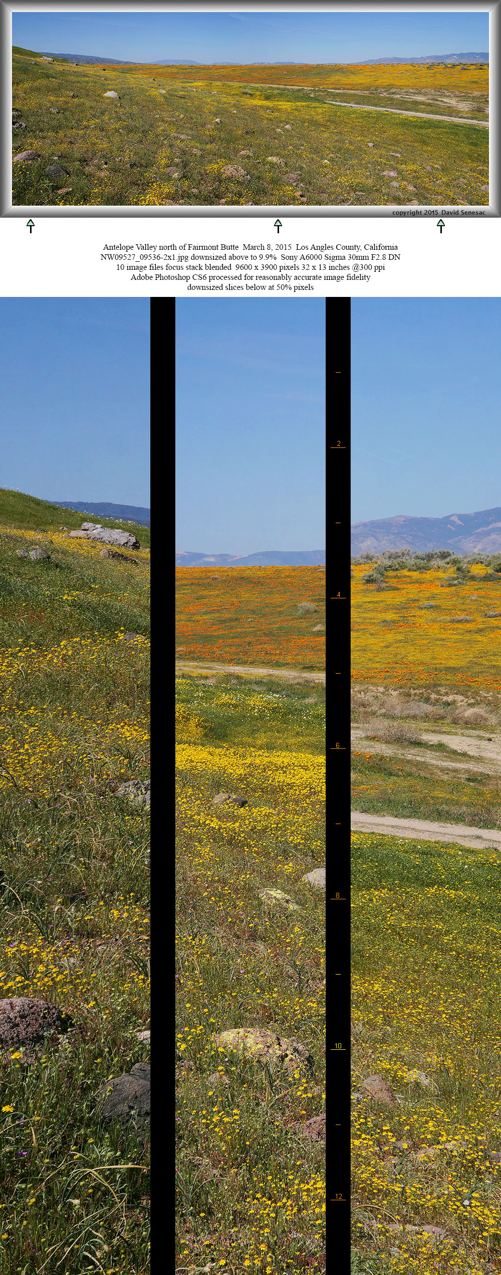
NW09527-09536-2x1h 9600x3900 pixels 2 frame 2 column 1 row 10 image focus stack stitch blend A6000 30mm
enlarged vertical slice view
Broad Canyon drains north off modest slopes of Portal Ridge onto plains of the valley then northeast along this area about the north side of Fairmont Butte that is actually just a variably wide shallow wash usually 20 to 30 feet deep. The above view west southwest taken at 12 noon PDT or an hour before midday, is a view from the south side of the wash that was primarily just goldfields with some creamcups looking down a half mile long section of the colorful north slope of the wash. One reason poppies dominate the north slope is the large flat plain above has a dense seed bed of poppies that after going to seed are blown in winds over the brink. The dirt road can be seen at frame right with the sandy wash just beyond. Paved 170th St W is atop the plain at the far end frame left. The wash is a fortunate topographic gift to photographers because one can easily frame landscapes without including man-made structures as is the case on the plain while including either the distant mountains or just sky.

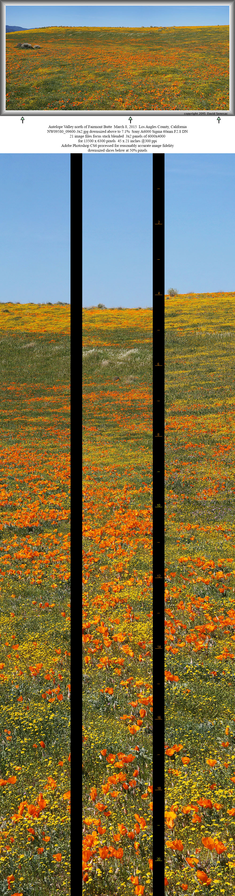
NW09580-09600-3x2h 13500x6300 pixels 6 frame 3 column 2 row 21 image focus stack stitch blend A6000 60mm
enlarged vertical slice view
Next image above captured at 12:30pm westward shows the north wall of Broad Canyon wash with dense goldfields and poppies. Throughout the wash zone the majority of goldfields had just recently come out because they were still quite fragrant as is the case when they have newly bloomed for just days. And all day my Bitterroot boots puffed up little clouds of yellow pollen.

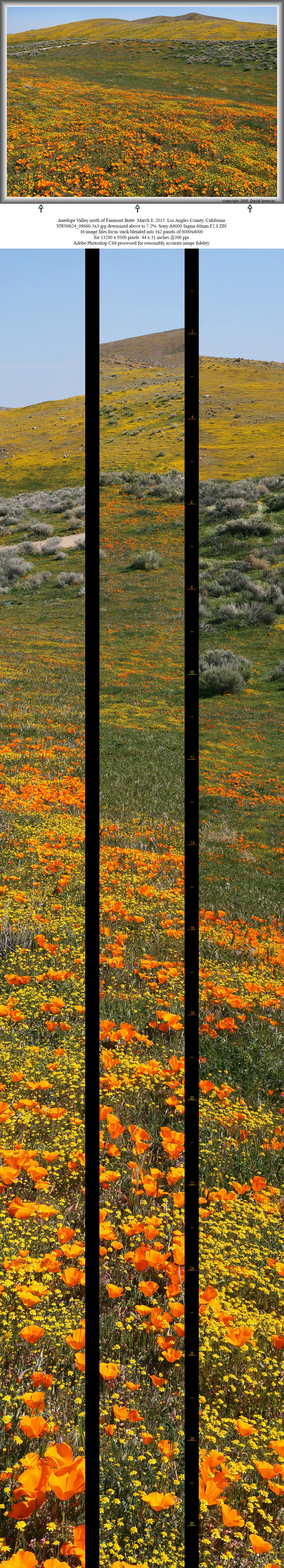
NW09624-09660-3x3h 13200x9300 pixels 9 frame 3 column 3 row 37 image focus stack stitch blend A6000 60mm
enlarged vertical slice view
At 12:45pm above, almost midday PDT, a view east towards Fairmont Butte, about 450 feet above the wash. A 3x3 set of 9 panels using 36 images or about 4 focus stack blended per panel. The greener slope mid ground is due to its more northerly aspect. An intermediate ridge of bright yellow goldfields is in front of the further more brown butte where goldfields had emerged weeks before losing their bright yellow hue. The light streak frame left is the dirt road. Note the small shadows on the left side of rabbitbush showing the modest sun altitude even at midday this equinox time of year. Also notice how areas next to rabbitbush are greener due to less sun and less wind desiccation. The white patch was dense creamcups that can be discerned with the enlarged vertical slice view.

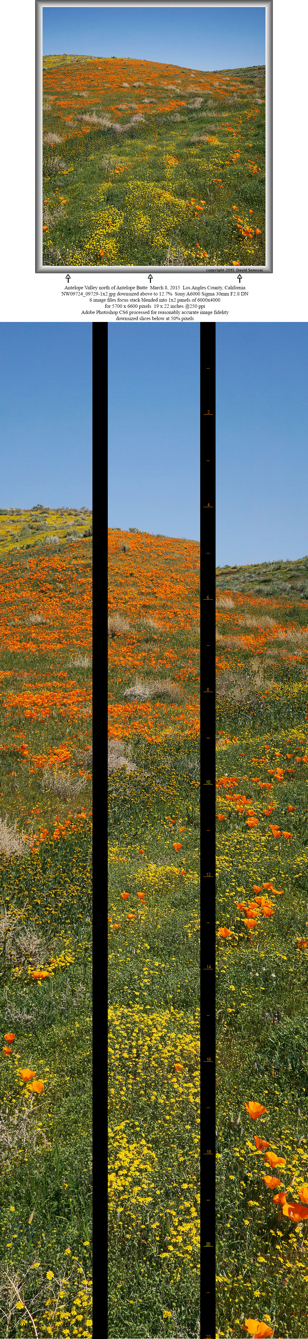
NW09724-09729-1x2h 5700x6600 pixels 2 frame 1 column 2 row 6 image focus stack stitch blend A6000 30mm
enlarged vertical slice view
Was time to fit some lunch in so walked back to the Subaru. Afterwards drove back on dirt roads to Antelope Buttes just outside the northern perimeter of AVCPR I'd surveyed late Saturday that had an especially dense patch of deeply orange poppies amid lush greens, above taken about 2pm. The brown plants are the alien dried Russian thistle aka tumbleweeds that plague many arid desert areas. Mid ground is a swath of freshly blooming orange hued fiddleneck, Amsinckia tessellata. Like the filaree, fiddleneck made an oddly stunted appearance this spring. Freshly emerged plants display a nice orange hue but increasingly flowers on their coiled cymes become more yellow and stems turn an unaesthetic muddy brown.

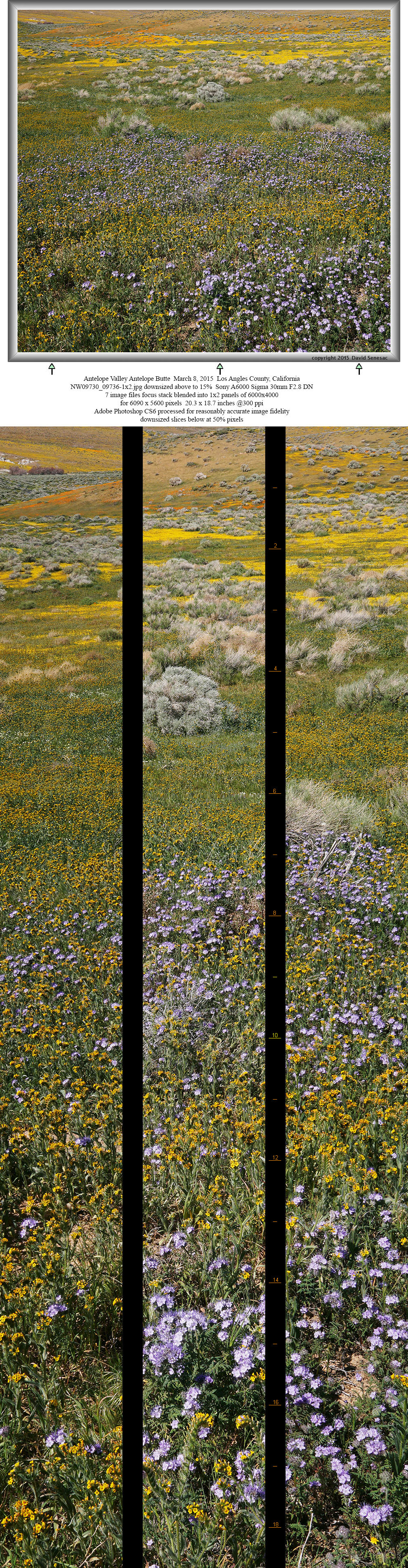
NW09730-09736-1x2h 6000x5500 pixels 2 frame 1 column 2 row 7 image focus stack stitch blend A6000 60mm
enlarged vertical slice view
Now an hour into the afternoon at 2:15pm, a view north above on the west side of the Antelope Buttes with lacy phacelia, Phacelia cryptantha, n the foreground amid nicely peaking fiddleneck, bands of rabbitbush, goldfields, and then poppies. And mid frame left are white areas of creamcups. Most of the year only the light cyan hued rabbitbush would be alive. Superbly suited for life in these arid regions, they bloom with dense small yellow flowers late summer into fall.

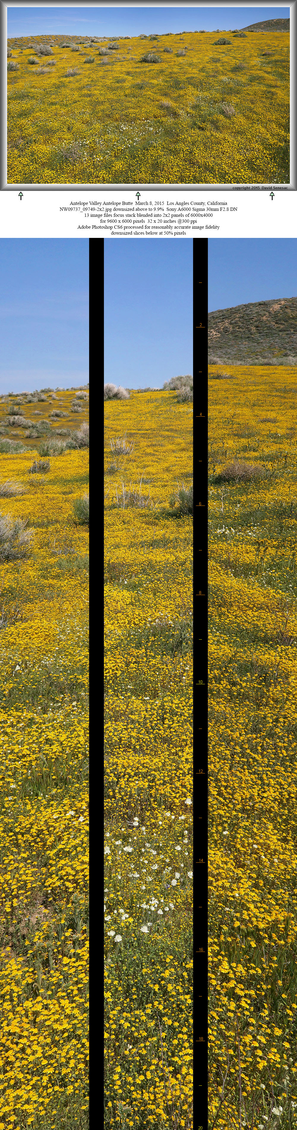
NW09737-09749-2x2h 9600x6000 pixels 4 frame 2 column 2 row 13 image focus stack stitch blend A6000 30mm
enlarged vertical slice view
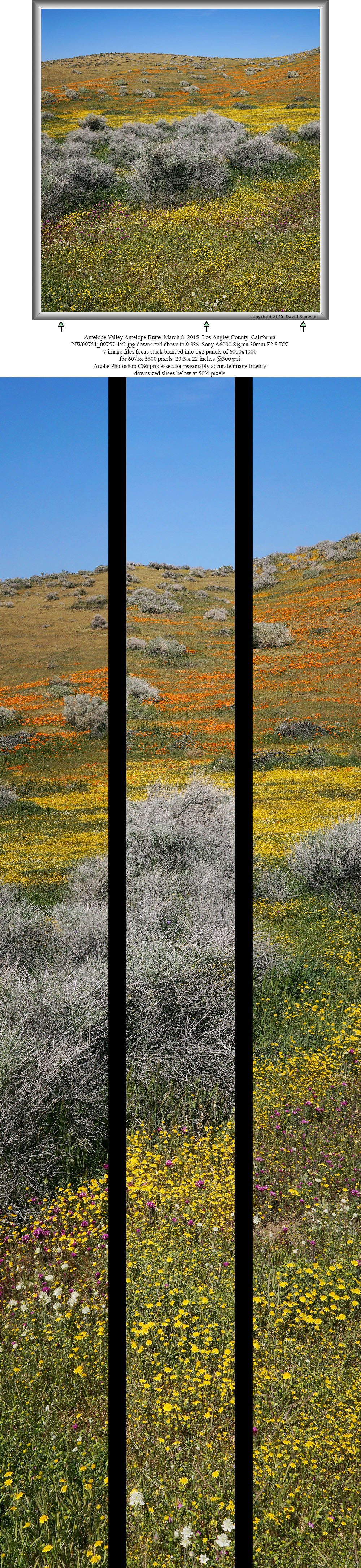
At about 2:20 pm a 2x2 panel above just about goldfields and rabbitbush though some lighter hued creamcups, Plastystemon californica, grace the center foreground. A few minutes later below, took a 2x2 panel of a hill with a sine wave skyline shape and some owl's clover and creamcups in the foreground. This closer view of the rabbitbush shows how most of the exposed outer branched are a lifeless gray while living stems tend to be down inside. Thus the dense shield of lifeless branches act as shade.

NW09751-09757-1x2h 6000x6500 pixels 2 frame 1 column 2 row 7 image focus stack stitch blend A6000 30mm
enlarged vertical slice view
NEXT: Page 3 Antelope Valley Carrizo Plain
2015 Trip Chronicles: Contents